
Wikipedia:Graphics Lab/Map workshop/Archive/Oct 2018
| This page is an archive. Do not edit the contents of this page. Please direct any additional comments to the current main page. |

India maps
-
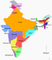 Majority languages of India by state
 -
 Suggested reference image


- Article(s)
- Hindi Belt, Languages with official status in India, List of languages by number of native speakers in India, plus nineteen pages on sixteen other projects
- Request
- This map shows the majority language of each state of India. Problem is, it doesn't show the state borders: you can see the border between Tamil Nadu and Kerala because they have different majority languages, but because Uttar Pradesh and Uttarakhand have the same majority language, there's no way to see where the border lies. If this were majority-language-by-region, state borders might not be relevant, but since it's majority-language-by-state, the state borders ought to be depicted. -- Nyttend (talk) 21:30, 6 October 2018 (UTC)
- Graphist opinion(s)
Request: Thetis Lake Trail Map
- Article(s)
- https://en.wikipedia.org/wiki/View_Royal
- Request
- Details of your request go here… -- ReliableShick (talk) 00:15, 8 October 2018 (UTC)
- Graphist opinion(s)
- Hi, First time requesting a map. Found this map on the official site, but since it's a Google Map, not sure if it breaks copyright. Figured better safe than sorry.
Thank you! ReliableShick (talk) 00:15, 8 October 2018 (UTC)ReliableShick
Re-draw some maps of the Trotuș-Buzău narrow-gauge rail network
- Article(s)
- ro:Calea ferată Covasna–Comandău
- ro:Calea ferată Onești–Scutaru
- ...
- Request
- This article contins 3 detailed maps of narrow-gauge railways in Romania, especially in the Easter Carpathians. One user who writes articles on the subject needs some help using them in his work. Since both authors are dead, releasing the maps seems difficult, so it might make sense to redraw them on top of OSM or some other background. I believe the priority should be Figure 2, then Figure 3, then Figure 1 (using the naming in the source). Thank you. -- Strainu (talk) 21:33, 14 October 2018 (UTC)
- Graphist opinion(s)
Scouting in Michigan

- Article(s)
- Scouting in Michigan
- Request
- please fix the spelling of "president" and remove the square-knot logo… -- Kintetsubuffalo (talk) 09:52, 17 October 2018 (UTC)
- Graphist opinion(s)
Guizhou

- Article(s)
- Guizhou
- Request
- please capitalize all ethnicities next to the white box, and match font… -- Kintetsubuffalo (talk) 02:55, 22 October 2018 (UTC)
- Graphist opinion(s)
Map for Catholic League (German)?
- Article(s)
- Catholic League (German)
- Request
- I know creating any new map for the Holy Roman Empire seems a monstrous task, due to the hundreds of quasi-independent legal entities. By ignoring the smaller ones and only mapping the, say 60 (?), largest states, it would me made easier by an order of magnitude. Still neccessary would be a list of the 50-60 largest principalities in 1618 by area, sortable by religion.
- Are the reliable sources needed to get this information already listed in Wikipedia? If not, how can I identify and access them? Do we already have (re-)usable maps for this purpose?
- What I would like the map to show:
- political borders within the Holy Roman Empire at 1618 (when the League became active militarily)
- catholic territories in light blue
- lutheran territories in light orange
- utraquist territories (Bohemia) in light red
- calvinist territories in light yellow
- extra marking for Electoral Palatinate and Kingdom of Bohemia (darker colors, bold frames?) to show them as a war faction in 1618
- extra marking for members of the Catholic League in 1618, same reason
- perhaps an extra frame to mark the Habsburg possessions within the HRE in 1618
- possibly an extra hatching for large territories that belonged to the Catholic Church at the Peace of Augsburg (1555) but had de facto turned Protestant before 1618. (mainly the archbishoprics of Bremen and Magdeburg)
- Ideally, the map should be in svg format so later editors can re-use it more easily. (I have about zero experience in making svg files.)
- The potential encyclopedic value of the new map is increased by its re-use potential. Iz could be the basis to create, for example, campaign maps for the Thirty Years War, maps to illustrate population decrease/fugitive movements/epidemics, change in religious affiliation and so on.
- Do you see this as a project worth pursuing for which I might get assistance from more experienced editors?
- p.s.: All of the above assumes that no suitable free maps already exist. Due to my inexperience I may not know the right places to look. If you know of maps that could be used for this, please say so. 2.247.241.235 (talk) 04:24, 1 October 2018 (UTC)
- Graphist opinion(s)
The best maps I know of showing the HRE are at German mediatization. Maproom (talk) 08:02, 2 October 2018 (UTC)
I have no time to take this on, but will point out that we do have 1618 HRE map in German that might make for a good starting point: File:Map_of_the_Holy_Roman_Empire_(1618)_-_DE.svg. Kmusser (talk) 15:39, 22 October 2018 (UTC)
Sissinghurst Castle Garden - Help with a plan/diagram
- Article(s)
- Sissinghurst Castle Garden
- Request
- I am working on an expansion of the above. It really needs a plan/diagram to help readers understand the layout of the castle and the surrounding gardens. Something like this, [1] would be ideal. However, I suspect that is a copyright infringement, as it appears to be a, very slightly reworked, mirror image of a plan that appears on the inside front cover of the 2008 National Trust guide. I am hoping one of the editors here would be able to produce an variant of it that I could use. I'm afraid it's far beyond my limited technical ability. Do let me know if you need another kind of map/illustration and I will see if I can find one. Thanks in advance. KJP1 (talk) 13:39, 30 September 2018 (UTC)
- Graphist opinion(s)
Request for a version of this particular world map with subdivisions added
{{resolved}}
- Article(s)
- N/A
- Request
- This isn't for wikipedia per se, but I don't know where else to turn. I can't seem to find this original particular map online anywhere, not on Wikipedia or anywhere else, let alone the version of it I need. I could try to free-hand it, but at this rate it would take weeks if not months, seeing how it is not a simply-defined national-border-type-map with borders single pixels wide, but varying wildly. I am simply not skilled enough to effectively do this, and need help.
Thanks. -Abbazorkzog (talk) 00:11, 25 November 2018 (UTC)
- Graphist opinion(s)
- @Abbazorkzog: I'm not completely sure what you're looking for, but would File:BlankMap-FlatWorld6.svg work? --AntiCompositeNumber (talk) 15:00, 25 November 2018 (UTC)
Update elections map

- Article(s)
- Alternative for Germany
- Request
- Alternative for Germany (AfD) now has elected representatives in every state parliament in Germany (please see the elections section of the article for more information). Therefore the map should be fully coloured blue.
- Graphist opinion(s)
I'm not sure that's entirely accurate. See the history of the image.Houdinipeter (talk) 19:19, 30 October 2018 (UTC)
Cabeza de Vaca

_-_DE.svg)

Route taken by Álvar Núñez Cabeza de Vaca from 1528 to 1536
- Article(s)
- Cabeza de Vaca
- Request
- borderless English version please… -- Kintetsubuffalo (talk) 22:04, 29 September 2018 (UTC)
- Graphist opinion(s)
@Kintetsubuffalo: Wonder if the mapframe version would be of any use. Shyamal (talk) 11:08, 30 October 2018 (UTC)