
Wikipedia talk:WikiProject New York City Public Transportation/Unidentified locations/Archive 2
| This is an archive of past discussions. Do not edit the contents of this page. If you wish to start a new discussion or revive an old one, please do so on the current talk page. |
| Archive 1 | Archive 2 | Archive 3 | Archive 4 |
Closed questions for January to March 2015 are here.
Mysterious cubbyhole at Kingston Avenue
Who knows the reason for these cubbyholes at Kingston Avenue (IRT Eastern Parkway Line)? ---------User:DanTD (talk) 18:15, 8 December 2014 (UTC)

- Can't say this or isn't a refuge cutout. Jim.henderson (talk) 18:43, 8 December 2014 (UTC)
- It's not for homeless people. You can see similar things at Woodhaven Blvd. station on queens line and continuing after station when going Manhattan bound. It is used during the construction of switching the platform layout of a station. First this is built. If this part reaches ceiling that means there will be a wall on the middle of platform. The cubby hole could be a break in the wall so people could change direction. After the construction of this part the station is definitely, shut down for a while and the former platforms are demolished and are replaced by track on demolished are and old tracks are removed. In place of old tracks would be new platform. The things in the middle will be covered with plaster and tiled. That's how they switch the platform layotut. This is widely seen across the subway due to the large extension plans that evolved turning stations to express stations, and centered platformed station. This was later abandoned so places where work was done to a small extent the work was abandoned as it can be seen on this station, and Woodhaven Blvd. and a few others. Doorknob747 23:42, 16 December 2014 (UTC) — Preceding unsigned comment added by Doorknob747 (talk • contribs)
- By chance if you were talking about those two gaps at the far end at the other end of the tube, then my mistake for the post above, those I think are emergency exit("Quite awkward if located at a subway stop. By chance I am not trying to say that you got the station image mixed up but is this station the south ferry loops, those two things might be the platform on the inner loop, because it is quite awkward for there to be a emergency exit at a station or a women's or men's dirty subway bathroom located where there is no platform. — Preceding unsigned comment added by Doorknob747 (talk • contribs) 00:21, 17 December 2014 (UTC)
- It's not for homeless people. You can see similar things at Woodhaven Blvd. station on queens line and continuing after station when going Manhattan bound. It is used during the construction of switching the platform layout of a station. First this is built. If this part reaches ceiling that means there will be a wall on the middle of platform. The cubby hole could be a break in the wall so people could change direction. After the construction of this part the station is definitely, shut down for a while and the former platforms are demolished and are replaced by track on demolished are and old tracks are removed. In place of old tracks would be new platform. The things in the middle will be covered with plaster and tiled. That's how they switch the platform layotut. This is widely seen across the subway due to the large extension plans that evolved turning stations to express stations, and centered platformed station. This was later abandoned so places where work was done to a small extent the work was abandoned as it can be seen on this station, and Woodhaven Blvd. and a few others. Doorknob747 23:42, 16 December 2014 (UTC) — Preceding unsigned comment added by Doorknob747 (talk • contribs)
Opposite platform

One more... before this discussion moves to another page. Vcohen (talk) 21:10, 5 November 2014 (UTC)
- Looks like 28th Street (IRT Broadway – Seventh Avenue Line) [citation needed] to me. But I don't see any signs for it, so I cannot be sure. Epicgenius (talk) 02:09, 6 November 2014 (UTC)
- Or maybe it's 23rd Street (BMT Broadway Line). Is it? I get confused with these two stations. Epicgenius (talk) 02:11, 6 November 2014 (UTC)
- Has to be Houston on the 1. 2604:2000:C6AC:D00:F44B:60B:C244:BD6C (talk) 06:44, 22 December 2014 (UTC)
- Or maybe it's 23rd Street (BMT Broadway Line). Is it? I get confused with these two stations. Epicgenius (talk) 02:11, 6 November 2014 (UTC)
Fulton complex?

Is this indeed a station of the Fulton Street complex? I could not find a photo of this pattern. Vcohen (talk) 21:17, 16 December 2014 (UTC)
- I saw the tile pattern before in that station. It must be in the IRT Broadway-Seventh Avenue section. Epicgenius (talk) 16:52, 7 January 2015 (UTC)
F above ground?
.jpg)
New question; All this says is "F train." I suspect it might be Carroll Street (IND Culver Line), but I need some genuine confirmation. ---------User:DanTD (talk) 00:38, 7 January 2015 (UTC)
- It is an above-ground station (see the truss in the upper corner) south of Smith-Ninth (the F goes from here to Smith-Ninth and then to Queens). The only station it can be is Fourth Avenue. Vcohen (talk) 08:11, 7 January 2015 (UTC)
- I saw the truss, but I thought it was for a high ceiling underground. Now I see it's for the platform canopy, so I'll change this. ---------User:DanTD (talk) 11:42, 7 January 2015 (UTC)
- Maybe I was too hasty. However, the picture has an additional clue: the reflection of the back wall in the window. Vcohen (talk) 15:44, 7 January 2015 (UTC)
- Well, well, well. It's Fourth Avenue (IND Culver Line). Epicgenius (talk) 16:52, 7 January 2015 (UTC)
- Maybe I was too hasty. However, the picture has an additional clue: the reflection of the back wall in the window. Vcohen (talk) 15:44, 7 January 2015 (UTC)
- I saw the truss, but I thought it was for a high ceiling underground. Now I see it's for the platform canopy, so I'll change this. ---------User:DanTD (talk) 11:42, 7 January 2015 (UTC)
320

Hey, if we could step outside the MTA for a moment, this overhead light has been nagging me for years. Does anybody know which Port Authority Trans-Hudson station contains this mysterious "320" light? ---------User:DanTD (talk) 04:25, 2 November 2014 (UTC)
- My best guess is Journal Square, in the bus terminal area. It does look like the signage at the PABT, but the photog says they were in the PATH system, so JSQ is my best guess. oknazevad (talk) 01:54, 7 December 2014 (UTC)
- Just another reason I'm sorry I didn't ride PATH when I was up in NYC last month. Journal Square was one of my considerations too. ---------User:DanTD (talk) 18:47, 8 December 2014 (UTC)
- It's not PATH. It's the Gate 320 of the Port Authority Bus Terminal. If you google, "port authority gate 320", you will an image of that. Mystery solved! Z22 (talk) 05:05, 22 January 2015 (UTC)
![]() Done. Congratulations. Jim.henderson (talk) 12:20, 24 January 2015 (UTC)
Done. Congratulations. Jim.henderson (talk) 12:20, 24 January 2015 (UTC)
Unidentified Culver Line station
Thanks for that. Now there's this one, which I suspect is another Culver Line station taken from the same general area. ---------User:DanTD (talk) 20:12, 7 January 2015 (UTC)
- I suspect that's West 8th Street station (the railing at the end of the platform is unique to that station; it doesn't look like the concrete railing of the Smith-9th and Fourth Ave stations, and it isn't a bare steel railing along the rest of the Culver line either). The F normally runs on the lower level, which means that this was a reroute. Epicgenius (talk) 03:48, 9 January 2015 (UTC)
- Okay, that makes sense. While we're at it, are we going to split off the images that were resolved for January 2015 in their own chapter, like we had with November 2014, and May-September 2014? ---------User:DanTD (talk) 23:02, 9 January 2015 (UTC)
- Actually, we can just split each picture. Epicgenius (talk) 02:02, 13 January 2015 (UTC)
- Okay, that makes sense. While we're at it, are we going to split off the images that were resolved for January 2015 in their own chapter, like we had with November 2014, and May-September 2014? ---------User:DanTD (talk) 23:02, 9 January 2015 (UTC)
BMT Fourth Avenue line?
.jpg)
How about this one; The MTA description claims this deicing train is at a station on the BMT Fourth Avenue Line, but their geotag says it's at a BMT Sea Beach Line station, specifically Eighth Avenue (BMT Sea Beach Line). They've certainly made mistakes like this in the past with some of their uploads, but you'd expect them to know better. ---------User:DanTD (talk) 14:13, 8 January 2015 (UTC)
- The staircase at the far end of the platform looks like this one. So, I think their camera location is correct. Vcohen (talk) 14:23, 8 January 2015 (UTC)
- Good. I'll move it to the right category. Whether I'll change the description I'm not too sure about. ---------User:DanTD (talk) 15:53, 8 January 2015 (UTC)
Coffee-Pastry and a Russian Film Festival?
.jpg)

This is truly a weird one, and a tough one. The name of the file is "Subway (2)," and the captions are entirely in Russian, but when I put it through the Bing Translator, I found something that had absolutely nothing to do with the subway station.
"At the same time in the two major world capitals-Moscow and New York opened an exhibition of the most outstanding young filmmakers and photographers of our time by Alexander Kargal′ceva. Don't miss out, who can, of course."
Okay, good to know. But this is about a subway station, not some Russian movie and photography exhibit. There is an apparent "Coffee and Pastry" shop behind it, with a partially obstructed word that I think might be "wichcraft." So where is this, and why did they misspell "Witchcraft?" ---------User:DanTD (talk) 14:25, 12 January 2015 (UTC)
- If you have some text in Russian, paste it here and I will translate it. Vcohen (talk) 14:32, 12 January 2015 (UTC)
- Thanks, but I believe I already did that above. However, if you insist;
"Одновременно в двух крупнейших мировых столицах - Москве и Нью-Йорке открываются выставки самого выдающегося из молодых режиссеров и фотографов современности Александра Каргальцева. Не пропустите, кто что может, конечно."
- Any reason to believe my English translation would be any different? ---------User:DanTD (talk) 14:46, 12 January 2015 (UTC)
- "...exhibitions opened of one of the most outstanding young filmmakers and photographers of our time, Alexander Kargaltsev." It's almost correct. My reason is that I know what automatic translation is. Try to translate "The only station's exit." with Google Translate to Russian and then back to English, you will get "Output only station in." Vcohen (talk) 18:57, 12 January 2015 (UTC)
- Any reason to believe my English translation would be any different? ---------User:DanTD (talk) 14:46, 12 January 2015 (UTC)
- As for one of the questions, `Wichcraft is a chain of high priced fast food shops in, far as I know, Manhattan only. See founder Tom Colicchio. Jim.henderson (talk) 14:42, 12 January 2015 (UTC)
- I just tried to look through their website for locations. So far I'm still only guessing. ---------User:DanTD (talk) 15:39, 12 January 2015 (UTC)
- Ah the Gimbels skyway eventually gave it away. North side of 32nd St, looking east from 6th Ave at PATH stair also used for 34th St station.
- Silly me; all true Manhattan oldtimers know Gimbles is west of Greeley Sq, not east. East side of Broadway, looking west. Jim.henderson (talk) 16:51, 12 January 2015 (UTC)
- I thought I saw that somewhere. Now I know. We can probably mark this as closed... Epicgenius (talk) 17:12, 12 January 2015 (UTC)
- So, that's the Gimbles skywalk. I knew about the closed Gimbels passageway between 33rd Street (PATH station) and Penn Station. ---------User:DanTD (talk) 21:34, 12 January 2015 (UTC)
- Can you remind me when the Gimbels passageway closed? I was born in the mid-1990s, and have never heard of such a passageway. Epicgenius (talk) 01:43, 13 January 2015 (UTC)
- It was part of my daily commute. ;http://nypost.com/2010/11/28/remembering-the-gimbels-tunnel/ Gimbels tunnel] NY Post Jim.henderson (talk) 02:09, 13 January 2015 (UTC)
- Cool, thanks for the link. Maybe I'll add some content in 34th Street – Herald Square (New York City Subway) or Penn Station about this passageway that I've never heard of before. Epicgenius (talk) 02:19, 13 January 2015 (UTC)
- If I ever start going back to Penn Station, I'll try to get a shot of the passageway where it's closed off with a huge gate. ---------User:DanTD (talk) 04:14, 13 January 2015 (UTC)
- Cool, thanks for the link. Maybe I'll add some content in 34th Street – Herald Square (New York City Subway) or Penn Station about this passageway that I've never heard of before. Epicgenius (talk) 02:19, 13 January 2015 (UTC)
- So, that's the Gimbles skywalk. I knew about the closed Gimbels passageway between 33rd Street (PATH station) and Penn Station. ---------User:DanTD (talk) 21:34, 12 January 2015 (UTC)
- I thought I saw that somewhere. Now I know. We can probably mark this as closed... Epicgenius (talk) 17:12, 12 January 2015 (UTC)
- I just tried to look through their website for locations. So far I'm still only guessing. ---------User:DanTD (talk) 15:39, 12 January 2015 (UTC)
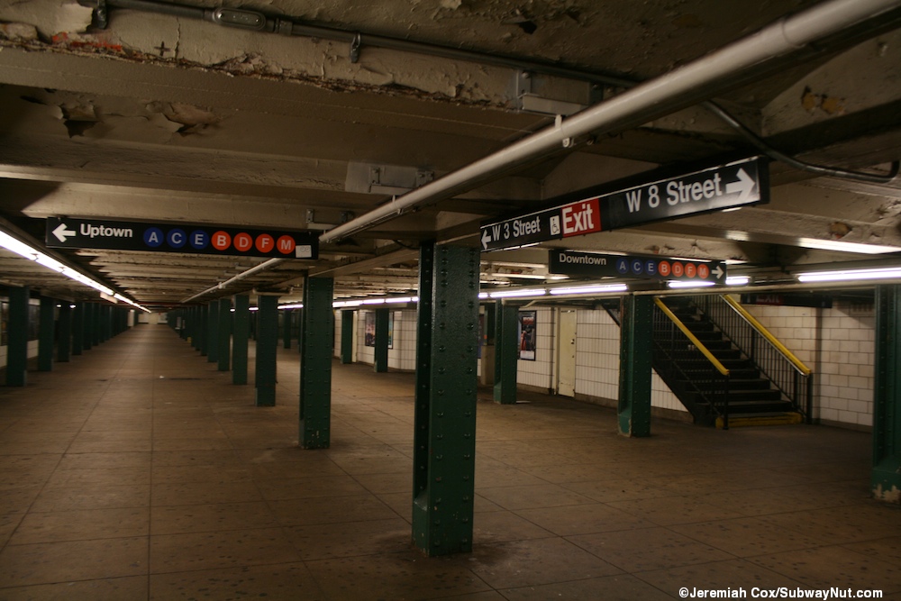
W4 and Fulton St stations
-
 Identified as W4
 -
 Identified as Fulton St.

.jpg)
@DanTD: I identified two more subway photos. You can double check my work:
--Z22 (talk) 06:06, 29 January 2015 (UTC)
- I don't doubt your conclusions whatsoever, but I'm very interested out of my own curiosity to learn how you identified them. Mind giving a short explanation? Pi.1415926535 (talk) 08:40, 29 January 2015 (UTC)
- I'd like to know that myself. In the meantime, there's still the one I'm going to put on the left. ---------User:DanTD (talk) 14:32, 29 January 2015 (UTC)
- For the Fulton Station, we know it is the #2 train and the station sign has it as "Fu...n". So that is left with only Fulton St. For the W4, I found a comparable photo from subwaynut. It's about the same location but on the left mezzanine rather than the right mezzanine in the original photo. Note, the original photo is older so they didn't have the direction signs that are there now. If you are not convinced yet, trace that white pipe work along the right columns of the original photo. The pipe recessed by the first column after the column that is next to the stairs. Also on the left columns at that location, you see the pipe work that crosses between the right and the left mezzanines. The locations of the pipe work match exactly to the subwaynut's photo. Z22 (talk) 17:30, 29 January 2015 (UTC)
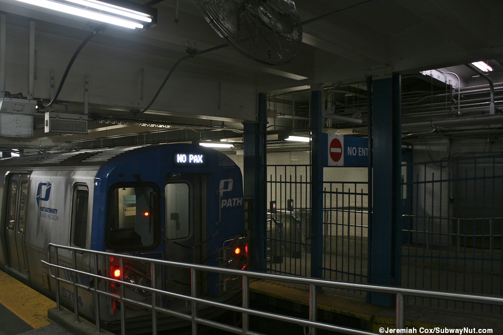
PATH again

I recently spotted a PATH train at an undetermined station. I assume this one is in Manhattan, but the coordinates places it north of 34th Street and south of Bryant Park. Obviously PATH doesn't go that far north or east, so I'm going to assume this is 33rd Street (PATH station). ---------User:DanTD (talk) 22:42, 19 January 2015 (UTC)
- Yes, 33rd street station. I moved to the right sub-category already. A proof? Here is another similar picture by SubwayNut guy. I think the GPS on smart phone may not be accurate when using inside a subway station. Just curious, why you say PATH "again"? Have you been spotting PATH pictures lately?
 Z22 (talk) 04:56, 22 January 2015 (UTC)
- I've been spotting plenty of stuff outside of the New York City Subway system, not just Port Authority related images. Until you told me that first image was at the Port Authority Bus Terminal, I would've assumed that was a PATH station. Now that it has been confirmed not to be one, I'll simply change it myself. ---------User:DanTD (talk) 13:25, 22 January 2015 (UTC)
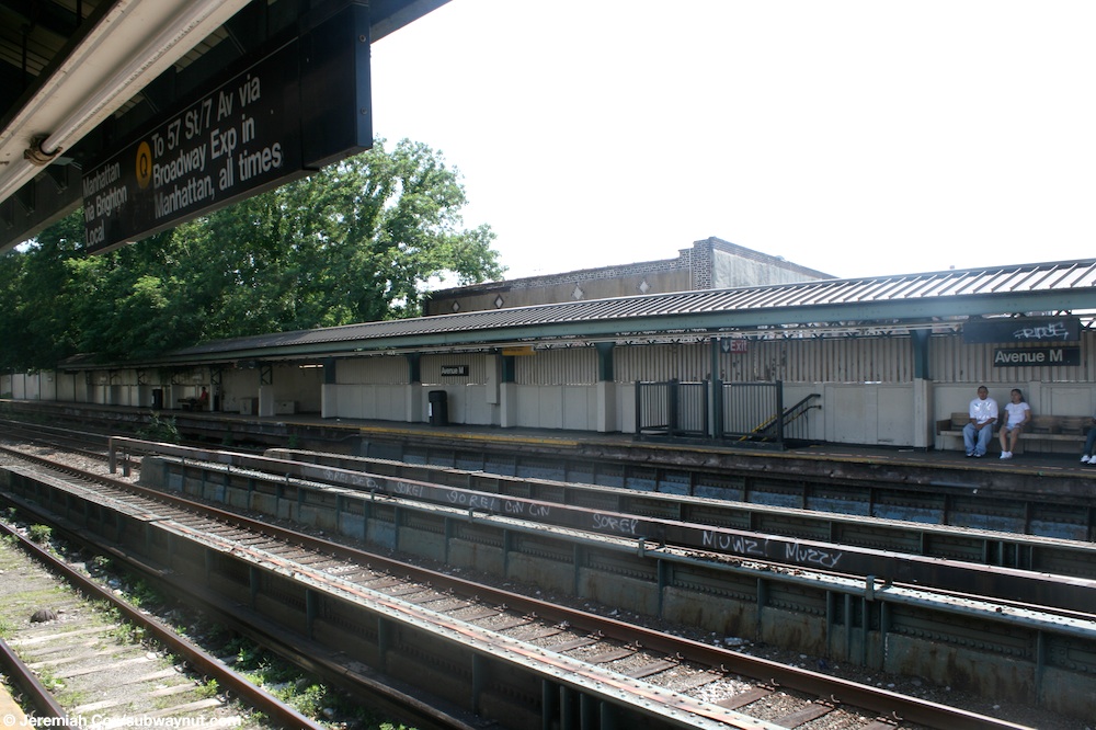
Brighton Line?

Where could it be? Is it Avenue M (BMT Brighton Line)? Vcohen (talk) 20:21, 7 February 2015 (UTC)
More subway stairs
I've got another mysterious location. The only clue seems to be some building in the background called the "Becker Building." ---------User:DanTD (talk) 03:14, 19 February 2015 (UTC)

- That's Union Square. It's the "Decker Building." --Scott Alter (talk) 03:40, 19 February 2015 (UTC)
M train in the 1970s
- For the image on the left, I think it is a WP:COPYVIO. The source is here. Many images that the original user who uploaded to Wikipedia (not the Commons) were deleted. So I doubt that the user was actually Doug Grotjahn (the photographer). So maybe we should do a speedy delete of the image on the basis on copyvio?? Z22 (talk) 04:09, 30 January 2015 (UTC)
- I believe years ago, somebody posted images in NYCSubway.org, and then re-posted them on Wikipedia, then those images tagged for deletion only for the uploader to insist he was the same person. I forget who it was, so perhaps we should hold off on Copyvio claims until we know for certain that they are. ---------User:DanTD (talk) 15:50, 30 January 2015 (UTC)
- I remember one such case, and it is not the same user. Vcohen (talk) 16:40, 30 January 2015 (UTC)
- Yes, I can see that. Not only that, the NYC subway link not only has the location (Jay Street – MetroTech (New York City Subway) on the BMT Fourth Avenue Line platforms), but also says it was taken in 1973, not 1977. It's a shame because that's a nice image. Perhaps we can use the link as a historic reference, and let readers know the M train used to go there. BTW, can we split these other images off from 33rd Street PATH station? ---------User:DanTD (talk) 17:05, 30 January 2015 (UTC)
- Done splitting Z22 (talk) 01:17, 31 January 2015 (UTC)
- Thanks, and now I see the image is gone. I was interested in adding the fact that the original uploader put all kinds of incorrect info on his upload, but I guess the copyvio notice stood on it's own. It almost makes me wonder if that uploader added the incorrect info deliberately, in order to conceal the fact that it was a copyright violation. ---------User:DanTD (talk) 01:07, 1 February 2015 (UTC)
- Done splitting Z22 (talk) 01:17, 31 January 2015 (UTC)
- Yes, I can see that. Not only that, the NYC subway link not only has the location (Jay Street – MetroTech (New York City Subway) on the BMT Fourth Avenue Line platforms), but also says it was taken in 1973, not 1977. It's a shame because that's a nice image. Perhaps we can use the link as a historic reference, and let readers know the M train used to go there. BTW, can we split these other images off from 33rd Street PATH station? ---------User:DanTD (talk) 17:05, 30 January 2015 (UTC)
- I remember one such case, and it is not the same user. Vcohen (talk) 16:40, 30 January 2015 (UTC)
- I believe years ago, somebody posted images in NYCSubway.org, and then re-posted them on Wikipedia, then those images tagged for deletion only for the uploader to insist he was the same person. I forget who it was, so perhaps we should hold off on Copyvio claims until we know for certain that they are. ---------User:DanTD (talk) 15:50, 30 January 2015 (UTC)
- For the image on the left, I think it is a WP:COPYVIO. The source is here. Many images that the original user who uploaded to Wikipedia (not the Commons) were deleted. So I doubt that the user was actually Doug Grotjahn (the photographer). So maybe we should do a speedy delete of the image on the basis on copyvio?? Z22 (talk) 04:09, 30 January 2015 (UTC)
Tracks

I cannot find this street on Google Street View, and cannot read the station name on the subway entrance. This image could be useful in two categories at least. Vcohen (talk) 16:22, 14 March 2015 (UTC)
- Image-description says "between Wyckoff & Irving" and there only three stations on those two streets to find a cross-street that matches the image. This image looks like it's of Halsey looking towards Wyckoff. It's not a through-street at the far intersection but has a lower-building, and the multistory two-tone brick building set back slightly on the near-right of that intersection matches too. DMacks (talk) 16:30, 14 March 2015 (UTC)
- Yes, this is the place. Thank you very much. What railroad is it? Vcohen (talk) 16:44, 14 March 2015 (UTC)
- Based on the shape of surrounding buildings, it looks like a spur of the New York Connecting Railroad, which is a few blocks to the east. --Scott Alter (talk) 17:22, 14 March 2015 (UTC)
- I just saw the remnants of that going as far west as Menahan Street, interrupted by a shopping center on the west side of Putnam Street between Ridgewood Place and Wyckoff Avenue. And yes, that was a spur of the New York Connecting Railroad. ---------User:DanTD (talk) 19:50, 14 March 2015 (UTC)
- Yeah, actually the Evergreen Branch to be precise. Epic Genius (talk) 01:31, 16 March 2015 (UTC)
- Funny that you should mention the Evergreen Branch, because I'm still trying to split that off from the Manhattan Beach Branch article. ---------User:DanTD (talk) 19:09, 25 March 2015 (UTC)
- Yeah, actually the Evergreen Branch to be precise. Epic Genius (talk) 01:31, 16 March 2015 (UTC)
- I just saw the remnants of that going as far west as Menahan Street, interrupted by a shopping center on the west side of Putnam Street between Ridgewood Place and Wyckoff Avenue. And yes, that was a spur of the New York Connecting Railroad. ---------User:DanTD (talk) 19:50, 14 March 2015 (UTC)
- Based on the shape of surrounding buildings, it looks like a spur of the New York Connecting Railroad, which is a few blocks to the east. --Scott Alter (talk) 17:22, 14 March 2015 (UTC)
- Yes, this is the place. Thank you very much. What railroad is it? Vcohen (talk) 16:44, 14 March 2015 (UTC)
Thanks! Vcohen (talk) 20:00, 14 March 2015 (UTC)
Subway stairs

Where is this? The "camera location" shows a point somewhere on Flatbush Avenue, but I could not find this staircase at any of the surrounding stations either on nycsubway.org or on subwaynut.com. Vcohen (talk) 21:57, 28 October 2014 (UTC)
- One of the exit signs says something about "Lafayette Avenue." I hope that's a clue. ---------User:DanTD (talk) 22:21, 28 October 2014 (UTC)
- I've seen it, but what does it add to the camera location? Vcohen (talk) 22:43, 28 October 2014 (UTC)
- To be honest, I'm not sure the cameral location is credible anymore. Fulton Street (IND Crosstown Line) and Lafayette Avenue (IND Fulton Street Line) seem fairly close to that area, but I can't be sure of which one of them has that staircase, or if either of them do. The IRT Eastern Parkway Line and BMT Brighton Line subways run under that stretch of Flatbush Avenue, but there's no station for either of those lines in that area. ---------User:DanTD (talk) 00:12, 29 October 2014 (UTC)
- A few times a month for several years around the turn of the century I used a short, wide staircase in the Flatbush Avenue / 4th Avenue station that looked much like this. I have only used about half the G train stations over the years, and don't remember any short broad staircases like this one. If my identification is correct, we are south of the skylight that used to be the station entrance, looking south. Beyond the turnstiles, the right passage led me to the west side of 4th Avenue, on the south side of Flatbush Av. Exits to Lafayette Street and Ashland are behind us, if I'm identifying correctly. Jim.henderson (talk) 21:28, 3 November 2014 (UTC)
- Excuse me, it looks like you are using non-conventional station names. Could you please provide a link to the appropriate article, so I could understand what you mean? Vcohen (talk) 22:16, 3 November 2014 (UTC)
- Honestly Jim, you lost me too. The closest station I can think of on the G train that's near the intersection of Lafayette and Ashland is Fulton Street (IND Crosstown Line), and that's north of the intersection of Flatbush and 4th Street... unless you're talking about Fourth Avenue (IND Culver Line) which is above ground and far too many blocks south of Flatbush Avenue, Lafayette Street, or Ashland Avenue. ---------User:DanTD (talk) 00:14, 4 November 2014 (UTC)
- Flatbush & Fourth is Atlantic Avenue – Barclays Center (New York City Subway). Maybe it is Fulton St station, but then again, I don't see a subway station. Epicgenius (talk) 02:56, 4 November 2014 (UTC)
- I can't even see evidence of former entrances to Fulton Street station there. And yes, I know that Flatbush & Fourth is Atlantic Avenue – Barclays Center (New York City Subway), and that was my original intuition, but there's no G train there. ---------User:DanTD (talk) 04:13, 4 November 2014 (UTC)
- We must remember that Jim said "to Lafayette... and Ashland". Maybe the exit, in Fulton Street IND Crosstown Line station, is facing toward that direction instead. – Epicgenius (talk) 13:21, 4 November 2014 (UTC)
- Pardon my clumsiness. I meant to deny this is any G Crosstown station, not to affirm it. Yes this is the station now called Barclay's if I haven't gone wrong on that, too. I will visit Brooklyn Heights next week and might go out of my way to use that station. Jim.henderson (talk) 18:34, 4 November 2014 (UTC)
- I'm beginning to think we need a page for station identification, with a section for each picture. Especially if I get more things wrong. No, Lafayette Avenue is one thing I definitely got wrong. Exit to Ashland Place, not so definite. And I definitely intend to visit my suspected location, a week and a half from now if not sooner. Jim.henderson (talk) 23:48, 4 November 2014 (UTC)
- If we do make a page for station identification, we'll probably need an "Empty category" tag for it. ---------User:DanTD (talk) 03:55, 5 November 2014 (UTC)
- I agree. We do need such a page. How about on Commons, since we all have accounts there? Epicgenius (talk) 18:27, 5 November 2014 (UTC)
- We already have commons:Category:Unidentified locations in the New York City Subway, and for PATH we have commons:Category:Unidentified locations in New York City and just commons:Category:Rail transport in unidentified locations in the United States if they're for any station outside of NYC. ---------User:DanTD (talk) 20:32, 5 November 2014 (UTC)
- One other thing about this picture; I just checked it again this morning, and the nearest station I was able to click on near that locations was Nevins Street (IRT Eastern Parkway Line). I was at Nevins Street back in November, and I saw nothing to indicate that it might be that station, although I hovered around the platforms and the crossunder between the two of them, so I didn't see the whole thing. ---------User:DanTD (talk) 14:44, 29 December 2014 (UTC)
- We already have commons:Category:Unidentified locations in the New York City Subway, and for PATH we have commons:Category:Unidentified locations in New York City and just commons:Category:Rail transport in unidentified locations in the United States if they're for any station outside of NYC. ---------User:DanTD (talk) 20:32, 5 November 2014 (UTC)
- I agree. We do need such a page. How about on Commons, since we all have accounts there? Epicgenius (talk) 18:27, 5 November 2014 (UTC)
- If we do make a page for station identification, we'll probably need an "Empty category" tag for it. ---------User:DanTD (talk) 03:55, 5 November 2014 (UTC)
- I can't even see evidence of former entrances to Fulton Street station there. And yes, I know that Flatbush & Fourth is Atlantic Avenue – Barclays Center (New York City Subway), and that was my original intuition, but there's no G train there. ---------User:DanTD (talk) 04:13, 4 November 2014 (UTC)
- Flatbush & Fourth is Atlantic Avenue – Barclays Center (New York City Subway). Maybe it is Fulton St station, but then again, I don't see a subway station. Epicgenius (talk) 02:56, 4 November 2014 (UTC)
- Honestly Jim, you lost me too. The closest station I can think of on the G train that's near the intersection of Lafayette and Ashland is Fulton Street (IND Crosstown Line), and that's north of the intersection of Flatbush and 4th Street... unless you're talking about Fourth Avenue (IND Culver Line) which is above ground and far too many blocks south of Flatbush Avenue, Lafayette Street, or Ashland Avenue. ---------User:DanTD (talk) 00:14, 4 November 2014 (UTC)
- Excuse me, it looks like you are using non-conventional station names. Could you please provide a link to the appropriate article, so I could understand what you mean? Vcohen (talk) 22:16, 3 November 2014 (UTC)
- I've seen it, but what does it add to the camera location? Vcohen (talk) 22:43, 28 October 2014 (UTC)
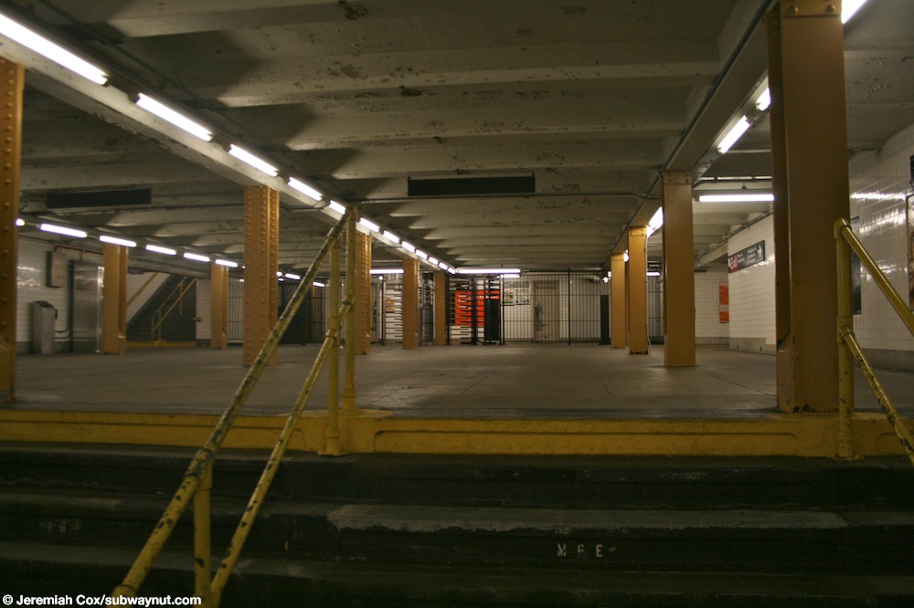
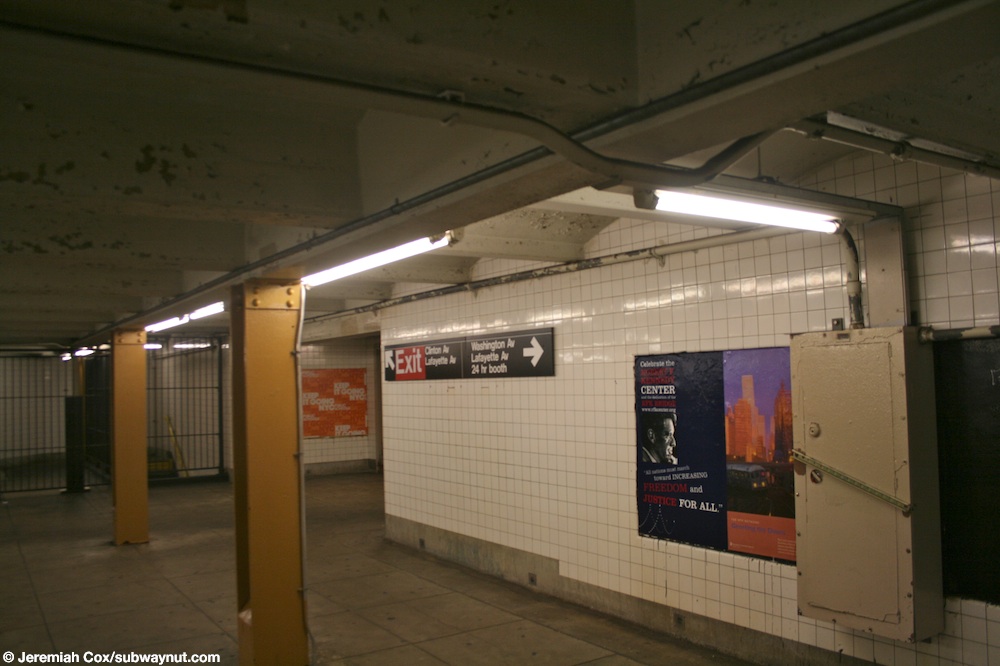
I have found a shot that looks very-very-very similar to the discussed one, except for the color of the columns. Can anybody prove me that it is not the same station? Vcohen (talk) 19:30, 10 February 2015 (UTC)
- I think this might be the sign that has been giving me the clue I've been looking at. Still, there's the issue of the columns being painted green rather than yellow. ---------User:DanTD (talk) 10:54, 15 March 2015 (UTC)
- This could be used as an evidence that the columns of Clinton–Washington Avenues (IND Crosstown Line) can be green as well. Vcohen (talk) 12:00, 15 March 2015 (UTC)
- I suppose it could, until you consider that Clinton–Washington Avenues (IND Fulton Street Line)'s columns have been green before this, but that station doesn't have an exit to Lafayette Avenue. ---------User:DanTD (talk) 16:36, 15 March 2015 (UTC)
- Let's see each image separately. The two on subwaynut.com are on Crosstown Line. The one on yelp.com is titled "23 photos for G Train," so it's on Crosstown Line too. Vcohen (talk) 21:23, 15 March 2015 (UTC)
- Okay, so it's the Crosstown Line station. Now for another question, when was it repainted? ---------User:DanTD (talk) 21:36, 15 March 2015 (UTC)
- The dates are: subwaynut.com (yellow) - from 2004 to 2009; yelp.com (green) - February 2015. That means that now the color is green and the yellow photos are outdated. The discussed image was uploaded in 2014, so the color changed between 2009 and 2014. Vcohen (talk) 21:47, 15 March 2015 (UTC)
- A little more: 2010 yellow, 2011 beige, 2013 green. The columns were repainted at least twice: once before 2011 and once after 2011. Vcohen (talk) 22:07, 15 March 2015 (UTC)
- Hey, that "Trains Stop Here" sign looks like nice. We should get a picture of that and add it to the gallery. In the meantime do any administrators want to archive this thread? ---------User:DanTD (talk) 03:51, 16 March 2015 (UTC)
- Okay, so it's the Crosstown Line station. Now for another question, when was it repainted? ---------User:DanTD (talk) 21:36, 15 March 2015 (UTC)
- Let's see each image separately. The two on subwaynut.com are on Crosstown Line. The one on yelp.com is titled "23 photos for G Train," so it's on Crosstown Line too. Vcohen (talk) 21:23, 15 March 2015 (UTC)
- I suppose it could, until you consider that Clinton–Washington Avenues (IND Fulton Street Line)'s columns have been green before this, but that station doesn't have an exit to Lafayette Avenue. ---------User:DanTD (talk) 16:36, 15 March 2015 (UTC)
- This could be used as an evidence that the columns of Clinton–Washington Avenues (IND Crosstown Line) can be green as well. Vcohen (talk) 12:00, 15 March 2015 (UTC)

- The columns were indeed repainted green. Since the pic at the top of the page, File:Clinton Washington mezzanine vc.jpg, was taken in a station under Lafayette Avenue, it is actually Clinton-Washington Avenues station, as indicated by the sign showing the exits oi the top right-hand corner. This is the exit to Clinton Avenue. Should that pic be renamed now? Epic Genius (talk) 17:05, 16 March 2015 (UTC)
 Done. Vcohen (talk) 19:50, 16 March 2015 (UTC)
- So Jim, you had the right line and right train, just the wrong station. At least we've got it now. ---------User:DanTD (talk) 19:59, 16 March 2015 (UTC)
- The columns were indeed repainted green. Since the pic at the top of the page, File:Clinton Washington mezzanine vc.jpg, was taken in a station under Lafayette Avenue, it is actually Clinton-Washington Avenues station, as indicated by the sign showing the exits oi the top right-hand corner. This is the exit to Clinton Avenue. Should that pic be renamed now? Epic Genius (talk) 17:05, 16 March 2015 (UTC)
Bay Ridge Avenue?

Am I right in categorizing this image? I did it by the R train and the bluish tiles. Vcohen (talk) 18:01, 17 March 2015 (UTC)
- The Bay Ridge Ave station doesn't have an escalator. I would say no. It's probably Rector Street (BMT Broadway Line) because the 4 train goes nearby. (There is a 4 train service advisory on the left side of the photo.) Epic Genius (talk) 02:25, 18 March 2015 (UTC)
- Thank you, your eyes see better than mine. However, why does the sign read R only, not N and R? Vcohen (talk) 06:34, 18 March 2015 (UTC)
- P.S. This color also can be found at Prospect Avenue (BMT Fourth Avenue Line). The question is which of these stations have escalators. Vcohen (talk) 12:03, 18 March 2015 (UTC)
It's because this photo was taken between August 2013 and September 2014, when the Montague Tubes were closed and the signage was changed to only display R service.Epic Genius (talk) 13:03, 18 March 2015 (UTC)- OK. But still, I cannot find a proof that Rector Street (BMT Broadway Line) has escalators. Vcohen (talk) 13:05, 18 March 2015 (UTC)
- Actually, I'm wrong. Prospect Avenue has turnstiles at platform level and is directly below the street, so it can't be Prospect Avenue. On further thought, though neither Rector Street nor Prospect Avenue have any overpasses or underpasses to connect the two platforms.
There's another sign on the far left, which says "1 service". I'd guess that this could have been South Ferry – Whitehall Street (New York City Subway), which definitely has escalators. This photo was taken in April 2012 (not between August 2013 and September 2014, as I'd guessed, so I've struck that comment out). However, the overhead signs in the subway system never show the late-night services. Epic Genius (talk) 13:16, 18 March 2015 (UTC)
- Sorry, I don't see the "1 service" sign. Vcohen (talk) 14:16, 18 March 2015 (UTC)
- It's to the far left. That sign is attached to the blue pillar, next to the other blue pillar with the telephone. It says "1 at platform ←". Epic Genius (talk) 14:48, 18 March 2015 (UTC)
- Yes, now I see it. But when I stretch the image horizontally, I see that it says something like "4 at 1 platform", but it's definitely impossible to read the digits. There is another sign, on the wall near the door, it has two arrows, and the arrow pointing to the right is labeled "R". The arrow pointing to the left seems to be labeled "2 3 4 5" with red and green circles, in a font smaller than that of the "R". Vcohen (talk) 15:04, 18 March 2015 (UTC)
- I think it's almost finally Court Street (BMT Fourth Avenue Line). Here the camera passes the same tunnel in the opposite direction. The sign I mentioned is visible at about 1:11. Vcohen (talk) 19:19, 18 March 2015 (UTC)
- Here it is! Vcohen (talk) 08:43, 19 March 2015 (UTC)
- Oh yeah, it was Court St/Boro Hall. Didn't recognize it. Epic Genius (talk) 15:26, 19 March 2015 (UTC)
- It's to the far left. That sign is attached to the blue pillar, next to the other blue pillar with the telephone. It says "1 at platform ←". Epic Genius (talk) 14:48, 18 March 2015 (UTC)
- Sorry, I don't see the "1 service" sign. Vcohen (talk) 14:16, 18 March 2015 (UTC)
- Actually, I'm wrong. Prospect Avenue has turnstiles at platform level and is directly below the street, so it can't be Prospect Avenue. On further thought, though neither Rector Street nor Prospect Avenue have any overpasses or underpasses to connect the two platforms.
- OK. But still, I cannot find a proof that Rector Street (BMT Broadway Line) has escalators. Vcohen (talk) 13:05, 18 March 2015 (UTC)
Overpass

I am somewhere between "not sure" and "have no idea"... Vcohen (talk) 19:41, 20 March 2015 (UTC)
- It's one of a series with the same date that are clearly Borough Hall (IRT Lexington Avenue Line). Our existing File:Borough Hall Station.jpg has some of the same features/details visible as the mystery image. DMacks (talk) 20:36, 20 March 2015 (UTC)
Turnstiles

The only thing I see here is an express station on Lexington Avenue Line with side platforms and without connection between directions. Is it 86th Street (IRT Lexington Avenue Line)? Vcohen (talk) 19:41, 20 March 2015 (UTC)
- Someone who's in the area could look for the location of the overhead next-train sign and the location of the yellowish/brownish tile station-name that is illegibly peaking out ("EET") just to the right of the right-hand large column in the foreground from the far wall of the opposite platform. Previous image in the flickr stream has an overhead sign for the exit to 86th&Lex. DMacks (talk) 20:39, 20 March 2015 (UTC)
Wait here sign on the G train

Vcohen, that second sign may have the same message, but it's not the same type of sign. Nevertheless, that needs a location now too. ---------User:DanTD (talk) 16:58, 17 March 2015 (UTC)
- Do you think it's possible to determine its location? There is nothing in the photo, but the sign itself. Vcohen (talk) 20:31, 17 March 2015 (UTC)
- If we decide to determine the location, let's split the image off onto it's own chapter here. ---------User:DanTD (talk) 16:57, 18 March 2015 (UTC)
- No problem. Vcohen (talk) 17:59, 18 March 2015 (UTC)
- This one is Bergen. 216.165.95.66 (talk) 18:56, 24 March 2015 (UTC)
- No problem. Vcohen (talk) 17:59, 18 March 2015 (UTC)
- If we decide to determine the location, let's split the image off onto it's own chapter here. ---------User:DanTD (talk) 16:57, 18 March 2015 (UTC)
Lexington Avenue Escalator
This image from Commons:Category:Unidentified locations in the New York City Subway seems to be either 59th Street (IRT Lexington Avenue Line) or 51st Street (IRT Lexington Avenue Line), and I'm leaning towards the former based on its apperance, but can anybody verify its location? rellmerr (talk page • contribs) 13:15, 12 January 2015 (UTC)
- Let me add two pictures to this question. I am afraid one of them is wrongly identified. Vcohen (talk) 13:25, 12 January 2015 (UTC)


- That is 59th Street. On the other hand, the escalator-stair combo at 51st Street has a different tiling. It also doesn't go that deep, as the escalator-stair combo at 59th Street does. Epicgenius (talk) 14:13, 12 January 2015 (UTC)
- So then is this the escalator between the express and local Lexington platforms, i.e. the one that doesn't go to the mezzanine under the BMT platform? rellmerr (talk page • contribs) 14:19, 12 January 2015 (UTC)
- That is correct. Epicgenius (talk) 15:04, 12 January 2015 (UTC)
- Before this is archived, I will note that File:ESCALATOR TRANSPORTS PASSENGERS FAR BELOW THE CITY STREETS TO THE LEXINGTON AVENUE LINE SUBWAY OPERATED BY THE NEW... - NARA - 556820.jpg is at 59 Street, but File:Lexington 53 Escalator vc.jpg and File:Lexington 53 Escalator 2 vc.jpg are at 53 Street. I'm pretty sure. The two 53rd Street escalators are different. One is at the western end, the other is the mid-platform down-only escalator. Epic Genius (talk) 21:41, 22 February 2015 (UTC)
- OK, thanks. Vcohen (talk) 22:16, 22 February 2015 (UTC)
- To clarify the 53/lex layout- there are 6 escalators in 4 banks layed out in a 2-1-1-2 pattern. The photos shown are of the western double and western single escalator. 216.165.95.66 (talk) 19:52, 24 March 2015 (UTC)
- OK, thanks. Vcohen (talk) 22:16, 22 February 2015 (UTC)
- Before this is archived, I will note that File:ESCALATOR TRANSPORTS PASSENGERS FAR BELOW THE CITY STREETS TO THE LEXINGTON AVENUE LINE SUBWAY OPERATED BY THE NEW... - NARA - 556820.jpg is at 59 Street, but File:Lexington 53 Escalator vc.jpg and File:Lexington 53 Escalator 2 vc.jpg are at 53 Street. I'm pretty sure. The two 53rd Street escalators are different. One is at the western end, the other is the mid-platform down-only escalator. Epic Genius (talk) 21:41, 22 February 2015 (UTC)
- That is correct. Epicgenius (talk) 15:04, 12 January 2015 (UTC)
- So then is this the escalator between the express and local Lexington platforms, i.e. the one that doesn't go to the mezzanine under the BMT platform? rellmerr (talk page • contribs) 14:19, 12 January 2015 (UTC)
- That is 59th Street. On the other hand, the escalator-stair combo at 51st Street has a different tiling. It also doesn't go that deep, as the escalator-stair combo at 59th Street does. Epicgenius (talk) 14:13, 12 January 2015 (UTC)
116th Street Station in 1973
I just found this one from the NARA archives, with the message "VANDALS HAVE SPRAY-PAINTED MESSAGES ON WALLS OF THIS SUBWAY STATION (116TH STREET)." But which "116th Street" station is this? Broadway, Eighth Avenue, Lenox Avenue, or Lexington Avenue? ---------User:DanTD (talk) 18:00, 19 January 2015 (UTC)
_-_NARA_-_548271.jpg)
- Well I'm not an expert on station identification, but if it's between those you've listed, I'd guess 116th Street (IRT Lexington Avenue Line). IND Eighth's has square tiles, and the other two both have only half of the height of the wall covered in white tiles. Lexington's is the only one that looks like that one of the four -- plus that bottom trim seems to closely match the one visible at 116th & Lex. I wouldn't say this for sure though. rellmerr (talk page • contribs) 21:44, 19 January 2015 (UTC)
R46
_R46_in_Lower_Manhattan.jpg)
This image on the right was taken in 2011, so it's not exactly new. Still, a question: does anyone have a hint as to which station this is? I'm thinking Broadway-Lafayette, but if anyone else has feedback, it would be great. Epic Genius (talk) 04:57, 13 February 2015 (UTC)
- The image description says it's an R train in Lower Manhattan, but none of the BMT Broadway Line's stations south of Union Square are island-platform stations with blue pillars and a blue trim. My first guess before I even read your comment or the description was Broadway-Lafayette Street, so that's my final verdict on this one. Correct me if I'm wrong, anybody. rellmerr (talk page • contribs) 02:10, 23 February 2015 (UTC)
- Why do you think it's an island platform? Vcohen (talk) 08:06, 23 February 2015 (UTC)
- In 2011, That was a Pitkin Car. If it was in lower Manhattan, my best guess based on lighting is that that is Canal. 216.165.95.66 (talk) 19:00, 24 March 2015 (UTC)
- Why do you think it's an island platform? Vcohen (talk) 08:06, 23 February 2015 (UTC)
Answering a previous one which was closed/archived
This is Utica Avenue on the IND Fulton line, not Fulton street in Manhattan. — Preceding unsigned comment added by 2604:2000:C6AC:D00:1541:2709:824A:E5F1 (talk) 23:01, 25 March 2015 (UTC)
- Thanks a million! Vcohen (talk) 08:07, 26 March 2015 (UTC)
- Just out of curiosity, this exit is to the one at Boys and Girls High School, right? ---------User:DanTD (talk) 12:20, 26 March 2015 (UTC)
- It has been 20 or so years since I have actually been outside of the station here, so I can't say exactly where it is. I recognize it from my wanderings within the station looking at second system elements. If I end up there sometime soon, I'll try and establish precisely which exit this is. 67.247.54.92 (talk) 05:46, 4 April 2015 (UTC)
- Just out of curiosity, this exit is to the one at Boys and Girls High School, right? ---------User:DanTD (talk) 12:20, 26 March 2015 (UTC)

Going by the signal plate format, This is on the IRT. It appears as if the chaining code is 30X(cant tell the third digit. 30 is confirmed by the chain below) over V. V is the code for the Seventh Avenue line. 3000 feet south of the zero (Between 42nd and 43rd street) for V is at around 31-32nd street. Unless my math is wrong, this is Penn Station on the 1-2-3. 2604:2000:C6AC:D00:1541:2709:824A:E5F1 (talk) 23:18, 25 March 2015 (UTC)
- Was at Penn Station IRT today, so I checked my hunch. Signal 301 V is at 30+00 in Penn Station, NB express track, immediately adjacent to the 33rd Street exit, so I was right! (same person as above since I am sure my IP has changed.) 67.247.54.92 (talk) 03:43, 4 April 2015 (UTC)
- I just moved it there tonight. Now about that exit at Utica Avenue (IND Fulton Street Line); is that the exit near Boys and Girls High School, or some other exit? ---------User:DanTD (talk) 03:55, 4 April 2015 (UTC)