Řepiště
Řepiště | |
|---|---|
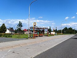
 Bus stop in the centre of Řepiště | |
| Coordinates: 49°44′0″N 18°19′2″E / 49.73333°N 18.31722°E | |
| Country | |
| Region | Moravian-Silesian |
| District | Frýdek-Místek |
| First mentioned | 1450 |
| Area | |
• Total | 8.00 km2 (3.09 sq mi) |
| Elevation | 305 m (1,001 ft) |
| Population (2024-01-01)[1] | |
• Total | 1,896 |
| • Density | 240/km2 (610/sq mi) |
| Time zone | UTC+1 (CET) |
| • Summer (DST) | UTC+2 (CEST) |
| Postal code | 739 32 |
| Website | repiste |
Řepiště (Polish: Rzepiszcze) is a municipality and village in Frýdek-Místek District in the Moravian-Silesian Region of the Czech Republic. It has about 1,900 inhabitants.
Geography
[edit]Řepiště is located about 5 kilometres (3 mi) north of Frýdek-Místek and 6 km (4 mi) south of Ostrava. It lies in the Ostrava Basin, in the historical region of Cieszyn Silesia. The municipality is situated on the right bank of the Ostravice River, which forms the western municipal border.
History
[edit]Řepiště was probably founded around 1270 under the name Barutov.[2] The first written mention of the village is in a document from 1450, in which Bolesław II, Duke of Cieszyn bequeath his wife Anna the territory of the Duchy of Teschen.[3]
Řepiště became a seat of a Catholic parish in the second half of 15th century. After 1540s Protestant Reformation prevailed in the Duchy of Teschen and a local Catholic church was taken over by Lutherans. It was taken from them (as one from around fifty buildings in the region) by a special commission and given back to the Roman Catholic Church on 26 March 1654.[4]
Demographics
[edit]
|
|
| ||||||||||||||||||||||||||||||||||||||||||||||||||||||
| Source: Censuses[5][6] | ||||||||||||||||||||||||||||||||||||||||||||||||||||||||
Transport
[edit]The train station named Paskov, which serves Řepiště and the neighbouring town of Paskov, is located in the territory of Řepiště. It lies on the railway line Ostrava–Frenštát pod Radhoštěm.
Sights
[edit]
The main landmark of Řepiště is the Church of Saint Michael the Archangel, part of the set of Silesian wooden churches. Based on dendrochronology, it was founded around 1424. At the end of the 17th century, it was extended. After 1819, the church was rebuilt into its present form.[7][8]
References
[edit]- ^ "Population of Municipalities – 1 January 2024". Czech Statistical Office. 2024-05-17.
- ^ "Stručná historie" (in Czech). Obec Řepiště. Retrieved 2022-03-02.
- ^ "Řepiště ve staletích". Zpravodaj obce Řepiště č. 140 (in Czech). Obec Řepiště. 2017-06-08. pp. 5–8. Retrieved 2022-03-02.
- ^ Broda, Jan (1992). "Materiały do dziejów Kościoła ewangelickiego w Księstwie Cieszyńskim i Państwie Pszczyńskim w XVI i XVII wieku". Z historii Kościoła ewangelickiego na Śląsku Cieszyńskim (in Polish). Katowice: Dom Wydawniczy i Księgarski "Didache". pp. 259–260. ISBN 83-85572-00-7.
- ^ "Historický lexikon obcí České republiky 1869–2011" (in Czech). Czech Statistical Office. 2015-12-21.
- ^ "Population Census 2021: Population by sex". Public Database. Czech Statistical Office. 2021-03-27.
- ^ "Kostel sv. Michaela archanděla" (in Czech). National Heritage Institute. Retrieved 2024-05-06.
- ^ "Dřevěný kostel sv. Michaela Archanděla" (in Czech). Obec Řepiště. Retrieved 2024-05-06.


