
Žvėrynas Bridge
Žvėrynas Bridge | |
|---|---|
 | |
| Coordinates | 54°41′25″N 25°15′32″E / 54.69028°N 25.25889°E |
| Crosses | Neris River |
| Locale | Vilnius |
| Preceded by | Iron Wolf Bridge |
| Followed by | Liubartas Bridge |
| Characteristics | |
| Total length | 103.1 metres (338 ft)[1] |
| Width | 11.35 metres (37.2 ft)[1] |
| Height | 11 metres (36 ft)[1] |
| History | |
| Opened | 1892 |
| Rebuilt | 1906 |
| Location | |
 | |
The Žvėrynas Bridge (Lithuanian: Žvėryno tiltas) is a bridge over the Neris River in Vilnius, Lithuania. It connects Naujamiestis with the district of Žvėrynas.
History[edit]
The bridge was first built of timber in 1892 by a landowner in Žvėrynas.[2] The landowner hoped to make Žvėrynas a part of the Vilnius city, as it was a suburb at that time.[2] The bridge was rebuilt by the city in 1906 using a steel structure with stone piers.[3] It was overhauled in 1937.[3] The bridge suffered significant damage during the World War II but was repaired quite quickly.[3] In 1991, during the January Events, defensive barricades were built on the bridge.
In 2014, LED lighting was installed for colourful illuminations in the evenings.[1]
Gallery[edit]
-
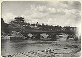 Timber bridge, circa 1900
 -
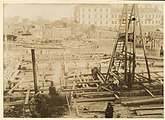 Construction in 1906
 -
 Bridge in 1934
 -
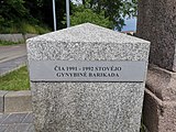 Commemorative stone about the 1991 barricades
 -
 Lights on the bridge
 -
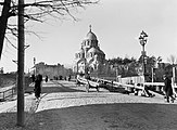
 Areal view, 2021


_bij,_Bestanddeelnr_252-1305.jpg)


References[edit]
- ^ a b c d "Žvėryno tiltas". MB "In Vilnius" (in Lithuanian). Archived from the original on 24 June 2022.
- ^ a b "Žvėryno seniūnija / Žvėrynas". Vilnijos vartai (in Lithuanian). Archived from the original on 19 July 2021.
- ^ a b c Kabeikis, Henrikas-Adolfas (2004). Žvilgsnis į Lietuvos tiltus (PDF). Kaunas: Kopa. p. 69. ISBN 9955-9711-0-X.