
14 km dorogi Kem-Kalevala
14 km dorogi Kem-Kalevala
14 км дороги Кемь-Калевала | |
|---|---|
Settlement | |
 14 km dorogi Kem-Kalevala  14 km dorogi Kem-Kalevala | |
| Coordinates: 64°55′16″N 34°21′42″E / 64.921111°N 34.361667°E | |
| Country | Russia |
| Region | Republic of Karelia |
| District | Kemsky District |
| Time zone | UTC+03:00 |
14 km dorogi Kem-Kalevala (Russian: 14 км дороги Кемь-Калевала) is a rural locality (a settlement) in Kemskoye Urban Settlement of Kemsky District, Russia. The population was 604 as of 2013.[1]
Geography
[edit]It is located 13 km west of Kemi, on the shore of the Putka reservoir.
History
[edit]Previously, it was also known as the village of Sokol, where military pilots of the 265th fighter aviation regiment of the Air Defense lived, and earlier the 828th assault aviation regiment, who served at the Poduzhemye airfield, located near the highway.
Transport
[edit]The federal highway R21 «Kola» passes through the village.
Education and culture
[edit]There is a Poduzhem secondary school.[2]
Historical monuments
[edit]A monument to the Su-15 aircraft is preserved in the village.
Gallery
[edit]- 14 km dorogi Kem-Kalevala
-
 Monument.
 -
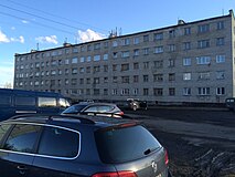
 Residential buildings.
 -
 Residential building.


References
[edit]- ^ "Численность населения в разрезе сельских населенных пунктов по состоянию НА 1 ЯНВАРЯ 2013Г". fulltext.library.karelia.ru. Retrieved 2018-08-08.
- ^ "МБОУ "Подужемская СОШ"" (in Russian).
This Republic of Karelia location article is a stub. You can help Wikipedia by expanding it. |