1912 Mürefte earthquake
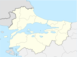
Location of epicenter in the Marmara region | |
| UTC time | 1912-08-09 01:29:03 |
|---|---|
| ISC event | 16958205 |
| USGS-ANSS | ComCat |
| Local date | 9 August 1912 |
| Local time | 03:29 |
| Magnitude | 7.4 Mw[1] |
| Depth | 15 km[2] |
| Epicenter | 40°42′N 27°12′E / 40.70°N 27.20°E[3] |
| Areas affected | Turkey |
| Max. intensity | MMI X (Extreme)[4] |
| Tsunami | 2.7 m (8 ft 10 in) |
| Casualties | 216–3,000 |
The 1912 Mürefte earthquake occurred at 03:29 local time on 9 August. It had an estimated magnitude of 7.4 Mw and a maximum intensity of X (Extreme) on the Modified Mercalli intensity scale, causing from 216 to 3,000 casualties.[4][5]
Earthquake
[edit]The earthquake was associated with faulting along the Ganos Fault, a segment of the North Anatolian Fault. Geologic trenching revealed coseismic offsets occurred along the entire 45 km (28 mi) onshort section of the Ganos Fault. These right-lateral displacements reached up to 5.5 m (18 ft). For its surface-wave magnitude (Ms 7.3–7.4), its corresponding rupture length would be approximately 135 ± 25 km (84 ± 16 mi). This implied the offshore segments east and west of the onshore Ganos Fault also ruptured. In the Marmara Sea, young fault scarps and right-lateral offsets up to 6 m (20 ft) were found. West of the Ganos Fault is the Saros Fault that lies beneath a bay; estimates of the Saros Fault rupture are between 20 km (12 mi) and 50 km (31 mi). Meanwhile, another 30–60 km (19–37 mi) of rupture may have extended eastwards into the Marmara Sea.[6]
Tsunami
[edit]A tsunami was associated with undersea landslides that triggered waves up to 2.7 m (8 ft 10 in) high. Evidence of landslides from the 1912 event were found at the southern edge of the Tekirdağ Basin. In the Bosporus Strait, the tsunami destroyed a yacht located at Paşabahçe.[7]
See also
[edit]References
[edit]- ^ Aksoy, M.E.; Meghraoui, M.; Vallée, M.; Çakır, Z. (2010). "Rupture characteristics of the A.D. 1912 Mürefte (Ganos) earthquake segment of the North Anatolian fault (western Turkey)". Geology. 38 (11): 991–994. Bibcode:2010Geo....38..991A. doi:10.1130/G31447.1.
- ^ "M 7.1 – 29 km SSE of Malkara, Turkey". United States Geological Survey. Retrieved 6 July 2021.
- ^ Ambraseys, N.N.; Jackson, J.A. (2000). "Seismicity of the Sea of Marmara (Turkey) since 1500". Geophysical Journal International. 141 (3): F1 – F6. Bibcode:2000GeoJI.141F...1A. doi:10.1046/j.1365-246x.2000.00137.x.
- ^ a b Boğaziçi Üniversitesi. "Bogazici University Kandilli Observatory and Earthquake Research Institute National Earthquake Monitoring Center (NEMC) List of earthquakes 1900–2004 (Büyük Depremler)" (in Turkish). Retrieved 28 August 2010.
- ^ NGDC (1972). "Significant Earthquake Information". National Geophysical Data Center / World Data Service (NGDC/WDS): Significant Earthquake Database. National Geophysical Data Center, NOAA. National Geophysical Data Center, NOAA. doi:10.7289/V5TD9V7K. Retrieved 28 August 2010.
- ^ Aksoy, M.E. (2021). "The 9 August 1912 Mürefte-Şarköy earthquake of the North Anatolian fault". Mediterranean Geoscience Reviews. 3: 95–114. doi:10.1007/s42990-021-00050-z.
- ^ Altinok, Y.; Alpar, B.; Yaltirak, C. (2003). "Tsunami of ŞArkoy-Mürefte 1912 Earthquake: Western Marmara, Turkey". In Yalçiner, A.C.; Pelinovsky, E.N.; Okal, E.; Synolakis, C.E. (eds.). Submarine Landslides and Tsunamis. NATO Science Series. Vol. 21. Springer, Dordrecht. pp. 33–42. doi:10.1007/978-94-010-0205-9_5. ISBN 978-1-4020-1349-2.
External links
[edit]- The International Seismological Centre has a bibliography and/or authoritative data for this event.

