
Adlergrund
Adlergrund
Ławica Orla | |
|---|---|
 | |
| Coordinates: 54°45′N 14°24′E / 54.750°N 14.400°E | |
| Sea | Baltic Sea |
| Region | Off Cape Arkona |
| Country | Germany |
| Minimum depth | 5 m |
Adlergrund (Polish: Ławica Orla)[1] is a shoal located in the Baltic Sea, at the SW end of the Rönnebank.
The shoal is a protected marine area with an extension of about 234 km2.[2]
Geography[edit]
It lies roughly 55 km to the ENE of Cape Arkona, the headland at the northern end of Rügen Island, and 60 km to the SSW of Bornholm. Geographically it is a SW extension of the Rönnebank that runs south of Bornholm.[3] The submerged shoal's shallowest point is about 5 meters deep at the time of the lowest astronomical tide.
History[edit]
Since it comprises large shallow areas dangerous for navigation, Lightship Adlergrund —a lightvessel of the German Hydrographic Office, was anchored on the reef in the period 1884 – 1914 and again in 1922 – 1941.[4]
-
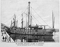 Lightship Adlergrund I (1884)
 -
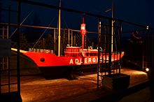 Lightship Adlergrund II (1922)
_b_517.jpg)
.jpg)
Currently the construction of two wind farms is planned on the Adlergrund Shoal under the name Wind Energy Network Rostock project.[5]
See also[edit]
References[edit]
- ^ Rozporządzenie Ministra Administracji Publicznej z dnia 11 lutego 1949 r. o przywróceniu i ustaleniu nazw miejscowości in Monitor Polski, 1949; number 17, section 225, p. 5
- ^ BfN - Das Schutzgebiet Adlergrund Archived 2017-09-30 at the Wayback Machine
- ^ GoogleEarth
- ^ Dr Józef Pluciński: Latarniowce na Zatoce Pomorskiej
- ^ "Wind Energy Network Rostock" (PDF). Archived from the original (PDF) on 2010-05-08. Retrieved 2016-08-31.
External links[edit]
This German location article is a stub. You can help Wikipedia by expanding it. |