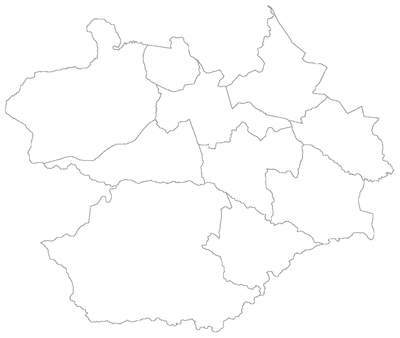
Administrative divisions of Santa Maria, Rio Grande do Sul
Appearance
This is a list of the administrative divisions of the municipality of Santa Maria, in the Brazilian state of Rio Grande do Sul.
Districts
[edit]The municipality is divided into 10 districts (Portuguese: distritos):
Map of the municipality of Santa Maria, Rio Grande do Sul, Brazil showing the division by districts.
| # | District | Distance from Sede |
Population (2010)[1] | Date of creation [2] |
|---|---|---|---|---|
| 1st | Sede ("municipal seat") | 0 km | 246,465 (94.4%) | 17 November 1837 |
| 2nd | São Valentim | 12 km | 565 (0.2%) | 19 December 1997 |
| 3rd | Pains | 15 km | 4,146 (1.6%) | 29 April 1914 |
| 4th | Arroio Grande | 18 km | 2,702 (1.0%) | 19 December 1988 |
| 5th | Arroio do Só | 36 km | 944 (0.4%) | 4 March 1896 |
| 6th | Passo do Verde | 23 km | 531 (0.2%) | 19 April 1991 |
| 7th | Boca do Monte | 16 km | 2,941 (1.1%) | 4 March 1896 |
| 8th | Palma | 18 km | 856 (0.3%) | 19 December 1997 |
| 9th | Santa Flora | 36 km | 1,074 (0.4%) | 27 July 1962 |
| 10th | Santo Antão | 11 km | 807 (0.3%) | 28 December 2001 |
| Total Municipal Population | 261 031 (100.0%) | |||
Apart from the 1st District, all the others are administered by Subprefects (subprefeitos), each of them appointed by the municipal Mayor.
Bairros and Administrative Regions
[edit]Santa Maria is officially organized in 50 bairros ("neighborhoods"), 41 of which are located in the 1st District of Sede ("Seat"), which accounts for 94.4% of the total population in the municipality. The remaining 9 bairros are coextensive with the 9 rural districts.
The 41 bairros of the Seat District are further grouped into 8 regiões administrativas (or R.A., "administrative regions").
| District | Administrative Region | Bairros |
|---|---|---|
| Sede | R.A. Center |
|
| R.A. Center-East |
| |
| R.A. Center-West |
| |
| R.A. East |
| |
| R.A. North |
| |
| R.A. Northeast |
| |
| R.A. South |
| |
| R.A. West |
| |
| São Valentim | — |
|
| Pains | — |
|
| Arroio Grande | — |
|
| Arroio do Só | — |
|
| Passo do Verde | — |
|
| Boca do Monte | — |
|
| Palma | — | |
| Santa Flora | — |
|
| Santo Antão | — |
|
- ^ Instituto Brasileiro de Geografia e Estatística (IBGE) (16 November 2011). "Sinopse por setores". Retrieved 3 February 2013.
- ^ Enciclopédia dos Municípios Brasileiros (2007). "Santa Maria - Histórico" (PDF). Instituto Brasileiro de Geografia e Estatística (IBGE). Archived (PDF) from the original on 5 November 2013. Retrieved 3 February 2013.
External links
[edit]- Political Map of Santa Maria (.pdf)
- (in Portuguese) The City's Official Website


