
Amaicha del Valle
You can help expand this article with text translated from the corresponding article in Spanish. (April 2010) Click [show] for important translation instructions.
|
Amaicha del Valle | |
|---|---|
 | |
 | |
| Country | |
| Province | Tucumán Province |
| Population (2001) | |
| • Total | 3,214 |
| Postal code | 4137 |
| Area code | 03892 |
Amaicha del Valle is a settlement in Tucumán Province in northern Argentina. It is located in the Tafi del Valle department, in the northwestern province of Tucuman, Argentina, 164 km from the provincial capital, San Miguel de Tucumán and 57 km from the departmental capital, Tafi del Valle.
It communicates with the city of San Miguel de Tucuman by the Ruta Nacional 38 and Route 307. It lies east of the RN 40, from which it is accessed in two ways: on the north by RP 357 (14 km), or from the south via Route 307 from the town of Santa María, Catamarca (20 km).
Geography[edit]
It is located in the area corresponding to the province of Tucuman Valles Calchaquíes, at a height of 2000 m.
Climate[edit]
| Climate data for Amaicha del Valle (1944–1976) | |||||||||||||
|---|---|---|---|---|---|---|---|---|---|---|---|---|---|
| Month | Jan | Feb | Mar | Apr | May | Jun | Jul | Aug | Sep | Oct | Nov | Dec | Year |
| Mean daily maximum °C (°F) | 31.2 (88.2) |
29.9 (85.8) |
29.2 (84.6) |
27.9 (82.2) |
25.8 (78.4) |
25.5 (77.9) |
24.7 (76.5) |
26.7 (80.1) |
28.9 (84.0) |
30.6 (87.1) |
31.0 (87.8) |
31.1 (88.0) |
28.5 (83.3) |
| Daily mean °C (°F) | 20.2 (68.4) |
19.7 (67.5) |
18.4 (65.1) |
14.9 (58.8) |
12.9 (55.2) |
10.2 (50.4) |
8.9 (48.0) |
11.4 (52.5) |
14.1 (57.4) |
17.5 (63.5) |
19.0 (66.2) |
20.0 (68.0) |
15.6 (60.1) |
| Mean daily minimum °C (°F) | 12.3 (54.1) |
12.0 (53.6) |
10.0 (50.0) |
7.0 (44.6) |
3.6 (38.5) |
1.0 (33.8) |
0.0 (32.0) |
2.1 (35.8) |
4.0 (39.2) |
7.1 (44.8) |
11.0 (51.8) |
12.0 (53.6) |
6.8 (44.2) |
| Average precipitation mm (inches) | 48.0 (1.89) |
38.4 (1.51) |
14.8 (0.58) |
1.7 (0.07) |
0.5 (0.02) |
0.5 (0.02) |
0.2 (0.01) |
0.4 (0.02) |
1.8 (0.07) |
5.5 (0.22) |
17.3 (0.68) |
31.0 (1.22) |
160.1 (6.30) |
| Average relative humidity (%) | 66 | 67 | 67 | 65 | 53 | 48 | 45 | 44 | 46 | 51 | 54 | 64 | 56 |
| Source: Secretaria de Mineria[1] | |||||||||||||
Photo gallery[edit]
-
 Amaicha del Valle.
 -
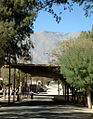 Village street.
 -
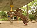 Carved Virgin.
 -
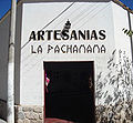 La Pachamama Cooperative.
 -
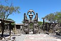 Pachamama Museum.
 -
 Town center at dusk.


.JPG)


References[edit]
- ^ "Provincia de Tucuman - Clima Y Meteorologia: Datos Meteorologicos Y Pluviometicos" (in Spanish). Secretaria de Mineria de la Nacion (Argentina). Archived from the original on October 11, 2009. Retrieved April 8, 2018.
| International | |
|---|---|
| National | |
26°36′S 65°55′W / 26.600°S 65.917°W
This article about a place in Tucumán Province, Argentina is a stub. You can help Wikipedia by expanding it. |