
Anakie Siding, Queensland
| Anakie Siding Queensland | |||||||||||||||
|---|---|---|---|---|---|---|---|---|---|---|---|---|---|---|---|
 Outskirts of Anakie, 2013 | |||||||||||||||
 Anakie Siding | |||||||||||||||
| Coordinates | 23°34′30″S 147°48′27″E / 23.5750°S 147.8075°E | ||||||||||||||
| Population | 155 (2021 census)[1] | ||||||||||||||
| • Density | 0.2698/km2 (0.6989/sq mi) | ||||||||||||||
| Postcode(s) | 4702 | ||||||||||||||
| Area | 574.4 km2 (221.8 sq mi) | ||||||||||||||
| Time zone | AEST (UTC+10:00) | ||||||||||||||
| Location |
| ||||||||||||||
| LGA(s) | Central Highlands Region | ||||||||||||||
| State electorate(s) | Gregory | ||||||||||||||
| Federal division(s) | Flynn | ||||||||||||||
| |||||||||||||||
Anakie Siding is a rural locality in the Central Highlands Region, Queensland, Australia.[2] It contains the town of Anakie.[3] It is a sapphire mining area. In 2021 census, the locality of Anakie Siding had a population of 155 people.[1]
Geography
[edit].jpg)
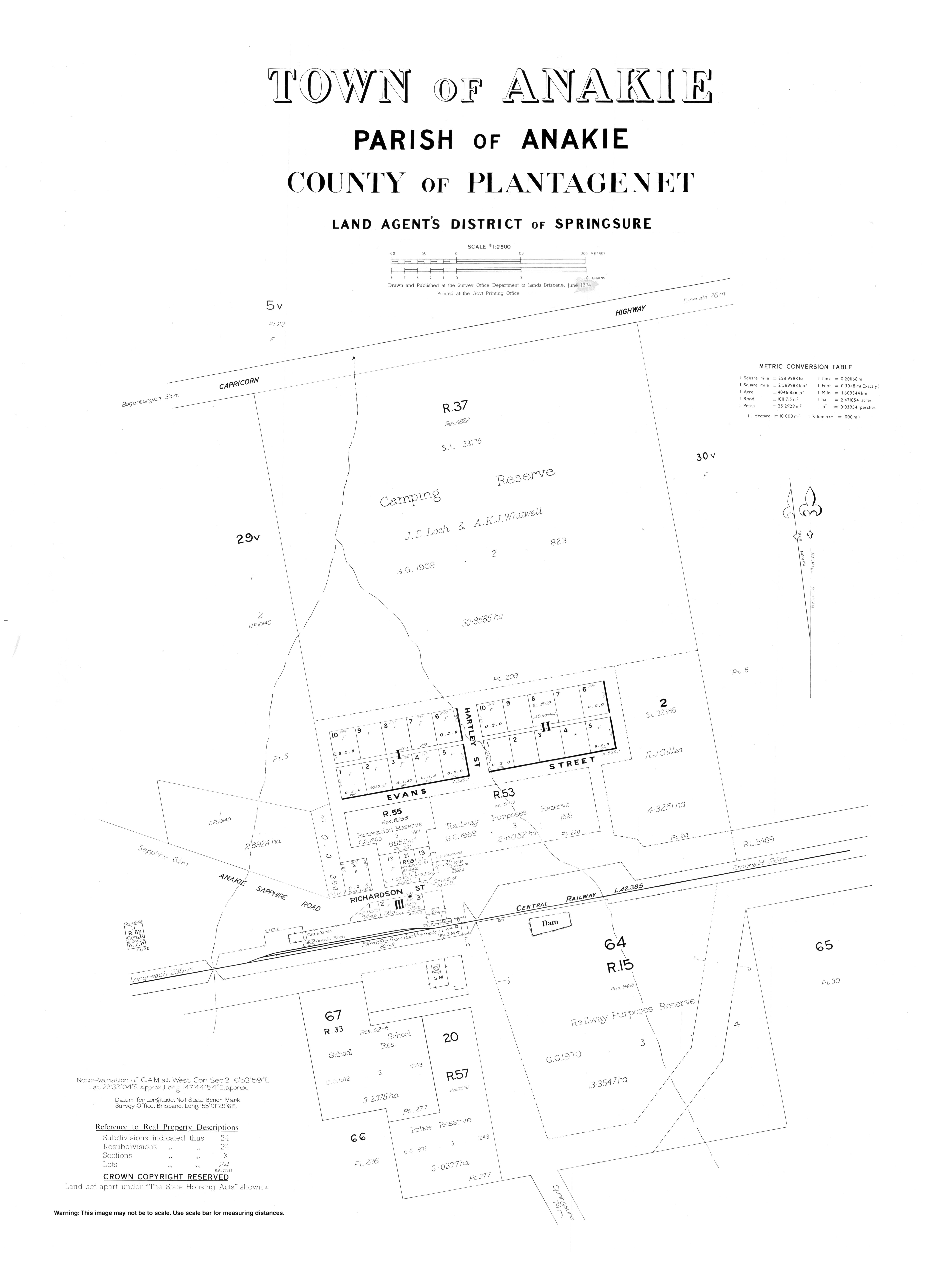
The town is located just to the south of the Capricorn Highway, 44 kilometres (27 mi) west of Emerald.
The town of Anakie is on the Central Western railway line running from Rockhampton west to Longreach. The town is served by the Anakie railway station (23°33′10″S 147°44′43″E / 23.5528°S 147.7453°E).[4] There is a railway siding at Taroborah (23°32′29″S 147°56′42″E / 23.5414°S 147.9450°E).[5][6]
There is a billabong to the south-east of the town (23°33′11″S 147°44′55″E / 23.5531°S 147.7485°E).[7]
In the north-west of the locality is The Three Sisters Range which extends north into Sapphire Central (midpoint 23°30′45″S 147°39′15″E / 23.5124°S 147.6542°E). It contains a number of unnamed peaks rising to 370 metres (1,210 ft) above sea level.[8]
History
[edit]The pastoral runs in the Leichhardt District[9] were surveyed by August 1866, including Anakie Downs, Saint Helens, Emerald Downs, and Glendarriwill.[10] At this time, the estimated 85 square miles (220 km2) Anakie Downs property was owned by R. Treffitt (also given as Triffit), who also owned the nearby Retreat run. On 17 January 1870 the 'superb station property known as the St. Helens, Anaki [sic], and Retreat runs situate on the Nogoa River, Leichhardt District, in the midst of the choicest and most remunerative stations in North Queensland', together with 10000 sheep, was sold by public auction to R. F. Greene for £2750.[11][12] The property was sold again by February 1880.[13]
A railway line west from Emerald Downs was considered for the area by the chief engineer for the Railway Department in 1878, but difficulties encountered with mountain ranges further to the west.[14][15] This line 'beyond Emerald Downs first passes through the good country known as Anaki [sic] Downs' was still unresolved by March 1878.[16] A 0.25 miles (0.40 km) rail siding had been added to the new line by November 1884.[17]
Anakie Provisional School was opened 27 July 1885.[18] On 1 January 1909, it became Anakie State School. It had occasional closures due to low student numbers.[19]
Anakie Post Office opened on 12 March 1894 (a receiving office had been open since 1885).[20]
Taraborah Provisional School opened in 1900. On 1 January 1909, it became Taraborah State School. It closed in 1911. The name is also written as Taroborah State School.[19]
By September 1902, the area was becoming known for sapphire mines, the nearest on Retreat Creek, 8 miles (13 km) from the Anakie railway station.[21] With granitic rock masses and adjoining metamorphic rocks including gneiss, with hornblende, some epidote, some ruby, and garnet, zircons were also found. The quality of the blue, red, and yellow sapphires was noted.
Anakie was one of three towns within the locality of The Gemfields (the others being Sapphire and Rubyvale) until 17 April 2020, when the Queensland Government decided to replace The Gemfields with three new localities (Anakie Siding, Sapphire Central and Rubyvale) based around each of the three towns respectively. The boundaries of the localities of Emerald and Gindie were also modified to accommodate the introduction of the locality of Anakie Siding with an area of 574.4 square kilometres (221.8 sq mi).[22][23][24][25]
Demographics
[edit]In 2021 census, the locality of Anakie Siding had a population of 155 people.[1]
Transport
[edit]Greyhound buses run west (and return) from Rockhampton along the Capricorn Highway.[26]
Emerald (about 44 kilometres (27 mi) east) has an airport with regular services to Brisbane and other points.
Queensland Rail's Spirit of the Outback train service that runs twice weekly will stop at Anakie on request.
Education
[edit]Anakie State School is a government primary (Prep-6) school for boys and girls at 1 School Lane (23°33′14″S 147°44′45″E / 23.5540°S 147.7458°E).[27][28][29] In 2017, the school had an enrolment of 83 students with 7 teachers (6 full-time equivalent) and 7 non-teaching staff (4 full-time equivalent).[30] It has a cattle club which attends local agricultural shows to enter the junior cattle judging competitions.[31]
There are no secondary schools in Anakie. The nearest secondary school is Emerald State High School in Emerald to the east.[32]
References
[edit]- ^ a b c Australian Bureau of Statistics (28 June 2022). "Anakie Siding". 2021 Census QuickStats. Retrieved 30 June 2022.
- ^ "Anakie – bounded locality in the Central Highlands Region (entry 50495)". Queensland Place Names. Queensland Government. Retrieved 17 July 2020.
- ^ "Anakie – population centre in the Central Highlands Region (entry 558)". Queensland Place Names. Queensland Government. Retrieved 17 July 2020.
- ^ "Anakie – railway station in Central Highlands Region (entry 560)". Queensland Place Names. Queensland Government. Retrieved 22 March 2020.
- ^ "Taroborah – railway siding in Central Highlands Region (entry 33101)". Queensland Place Names. Queensland Government. Retrieved 28 November 2019.
- ^ "Layers: Locality; Road and rail; Railways; Railway stations". Queensland Globe. Queensland Government. Retrieved 26 January 2025.
- ^ "Layers: Locality; Mountains and ranges; Contours; Watercourses". Queensland Globe. Queensland Government. Retrieved 26 January 2025.
- ^ "The Three Sisters Range – mountain range in the Central Highlands Region (entry 34162)". Queensland Place Names. Queensland Government. Retrieved 17 July 2020.
- ^ Keogh, F. T. F.; F.E. Hiscocks & Co.; Watson, Ferguson & Co. (1878), "1 map : col. ; 50.8 x 39.1 cm.", Map of the Leichhardt district Queensland, [Brisbane: Watson, Ferguson, & Co, nla.obj-231141445, archived from the original on 1 June 2022, retrieved 29 September 2021 – via Trove
- ^ "Government notifications". The Queenslander. Vol. I, no. 29. Queensland, Australia. 18 August 1866. p. 6. Archived from the original on 1 June 2022. Retrieved 29 September 2021 – via National Library of Australia.
- ^ "Advertising". Northern Argus. No. 955. Queensland, Australia. 15 December 1869. p. 3. Archived from the original on 1 June 2022. Retrieved 29 September 2021 – via National Library of Australia.
- ^ "Commercial Intelligence". The Queenslander. Vol. VI, no. 295. Queensland, Australia. 30 September 1871. p. 4. Archived from the original on 1 June 2022. Retrieved 29 September 2021 – via National Library of Australia.
- ^ "Brown and Risen's Stock and Station Report". The Morning Bulletin (Rockhampton). Vol. XXV, no. 3716. Queensland, Australia. 7 February 1880. p. 2. Archived from the original on 1 June 2022. Retrieved 29 September 2021 – via National Library of Australia.
- ^ "Correspondence". The Morning Bulletin (Rockhampton). Vol. XXI, no. 3113. Queensland, Australia. 23 March 1878. p. 3. Archived from the original on 1 June 2022. Retrieved 29 September 2021 – via National Library of Australia.
- ^ "The Central Railway". The Morning Bulletin (Rockhampton). Vol. XXIII, no. 3469. Queensland, Australia. 29 May 1879. p. 2. Retrieved 29 September 2021 – via National Library of Australia.
- ^ "The week". The Morning Bulletin (Rockhampton). Vol. XXI, no. 3113. Queensland, Australia. 23 March 1878. p. 2. Archived from the original on 1 June 2022. Retrieved 29 September 2021 – via National Library of Australia.
- ^ "Emerald". The Morning Bulletin (Rockhampton). Vol. XXXIII, no. 5310. Queensland, Australia. 1 November 1884. p. 6. Archived from the original on 1 June 2022. Retrieved 29 September 2021 – via National Library of Australia.
- ^ "Opening and closing dates of Queensland Schools". Queensland Government. Retrieved 18 April 2019.
- ^ a b Queensland Family History Society (2010), Queensland schools past and present (Version 1.01 ed.), Queensland Family History Society, ISBN 978-1-921171-26-0
- ^ Phoenix Auctions History. "Post Office List". Phoenix Auctions. Archived from the original on 1 June 2022. Retrieved 14 February 2021.
- ^ "MINING". The Sydney Mail and New South Wales Advertiser. Vol. LXXIV, no. 2200. New South Wales, Australia. 6 September 1902. p. 636. Archived from the original on 1 June 2022. Retrieved 29 September 2021 – via National Library of Australia.
- ^ "Recent place name decisions: Job number 18-115: The Gemfields". Queensland Government. 17 April 2020. Archived from the original on 17 July 2020. Retrieved 17 July 2020.
- ^ "Proposed Locality Boundaries and Names: Anakie Siding, Argyll, Emerald, Gindie, Lochington, Minerva, Rubyvale and Sapphire Central" (PDF). Queensland Government. 2019. Archived (PDF) from the original on 17 July 2020. Retrieved 17 July 2020.
- ^ "Locality Boundaries and Names: Anakie Siding, Argyll, Emerald, Gindie, Lochington, Minerva, Rubyvale and Sapphire Central" (PDF). Queensland Government. 17 April 2020. Archived (PDF) from the original on 17 July 2020. Retrieved 17 July 2020.
- ^ "Layers: Locality; Population centres". Queensland Globe. Queensland Government. Retrieved 26 January 2025.
- ^ Greyhound Australia (20 May 2021). "Greyhound service timetable for: Longreach > Rockhampton" (PDF). Greyhound Australia. Archived (PDF) from the original on 2 June 2021. Retrieved 29 May 2021.
- ^ "State and non-state school details". Queensland Government. 9 July 2018. Archived from the original on 21 November 2018. Retrieved 21 November 2018.
- ^ "Anakie State School". Archived from the original on 4 April 2021. Retrieved 25 March 2021.
- ^ "Anakie State School" (Map). Google Maps. Retrieved 18 December 2022.
- ^ "ACARA School Profile 2017". Archived from the original on 22 November 2018. Retrieved 22 November 2018.
- ^ "Clubs and societies". Anakie State School. 25 March 2019. Retrieved 18 December 2022.
- ^ Cite error: The named reference
GLOBEwas invoked but never defined (see the help page).
Further reading
[edit]- Anakie State School. (1984). And then there was one : Anakie 1885-1985. Anakie State School. — via State Library of Queensland. Includes Sapphire State School, Rubyvale State School, Bogantungan State School, Lochington State School, Taroborah Provisional School, and Withersfield State School.