
Argon Tower
| Argon Tower | |
|---|---|
 Southeast aspect | |
| Highest point | |
| Elevation | 4,750 ft (1,448 m)[1] |
| Prominence | 230 ft (70 m)[1] |
| Parent peak | The Organ (4,735 ft)[2] |
| Isolation | 0.28 mi (0.45 km)[2] |
| Coordinates | 38°37′59″N 109°36′07″W / 38.633081°N 109.602056°W[1] |
| Geography | |
 Argon Tower Location in Utah  Argon Tower Argon Tower (the United States) | |
| Country | United States |
| State | Utah |
| County | Grand |
| Protected area | Arches National Park |
| Parent range | Colorado Plateau[1] |
| Topo map | USGS The Windows Section |
| Geology | |
| Rock age | Jurassic |
| Rock type | Entrada Sandstone |
| Climbing | |
| First ascent | 1964 by Layton Kor[3] |
| Easiest route | class 5.9 climbing[2] |
Argon Tower is a 4,750-foot-elevation (1,448-meter) pillar in Grand County, Utah. It is located within Arches National Park and like many of the rock formations in the park, Argon Tower is composed of Entrada Sandstone. The tower is 260 feet tall,[4] and topographic relief is significant as the summit rises 450 feet (137 meters) vertically above the Park Avenue Trail in 400 feet (122 meters) laterally. Precipitation runoff from Argon Tower drains to the nearby Colorado River via Courthouse Wash. This landform was shown briefly in the opening scene credits of the 1989 American action-adventure film Indiana Jones and the Last Crusade.
Climbing
[edit]The first ascent of the summit was made January 17, 1964, by Layton Kor, Bob Bradley, and Charlie Kemp via the class 5.9 North Face.[5][6] Layton Kor named this tower.[7]
Other rock-climbing routes on Argon Tower:
- North Northeast Arête - class 5.11[8]
- West Face - class 5.11 - John Pease, Steve Cheyney - (1972)[9]
Climate
[edit]According to the Köppen climate classification system, Argon Tower is located in a cold semi-arid climate zone with cold winters and hot summers.[10] Spring and fall are the most favorable seasons to experience Arches National Park, when highs average 60 to 80 °F (15 to 25 °C) and lows average 30 to 50 °F (0 to 10 °C). Summer temperatures often exceed 100 °F (40 °C). Winters are cold, with highs averaging 30 to 50 °F (0 to 10 °C), and lows averaging 0 to 20 °F (−20 to −5 °C). As part of a high desert region, it can experience wide daily temperature fluctuations. The park receives an average of less than 10 inches (25 cm) of rain annually.
Gallery
[edit]-
 Northeast aspect
 -
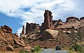
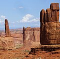
 Argon Tower to left, Tower of Babel (right)
 -
 Argon Tower left of center
 -
 Argon Tower centered
 -
 Argon Tower centered, south aspect, from Park Avenue Overlook
 -
 Argon Tower centered in the distance
 -
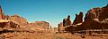
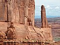
 Argon Tower (left), Three Gossips (right)
 -
 Argon Tower (left), Three Gossips, The Organ (right)
 -
 Argon Tower (left), The Organ (right). Layton Kor named Argon Tower, but later in life couldn't recall the reason why he chose that name. Perhaps it was a play on words: Argon ← Organ
 -
 Three Gossips (centered) and Argon Tower (left) viewed from the north
 -
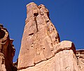
 Southeast aspect
 -
 Jello Tower (lower left) and Argon Tower (upper right)
 -
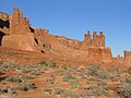
 Argon Tower (left), Tower of Babel (centered), The Candelabrum (right)
 -
 Argon to right of center, viewed from north


.jpg)
.jpg)

.jpg)


See also
[edit]References
[edit]- ^ a b c d "Argon Tower, Utah". Peakbagger.com.
- ^ a b c "Argon Tower - 4,700' UT". listsofjohn.com. Retrieved 2024-09-06.
- ^ The American Alpine Journal 1989, The Mountaineers Books, 1997, ISBN 9780930410391, p. 156.
- ^ Stewart M. Green, Rock Climbing Utah, Rowman & Littlefield, 2012, ISBN 9780762792849, p. 20.
- ^ First Ascent Timeline, deserttowersbook.com, Retrieved 2024-09-06.
- ^ Eric Bjørnstad, Desert Rock: Rock Climbs in the National Parks, Chockstone Press, 1996, ISBN 9781575400105.
- ^ Katy Cassidy, Canyon Country Climbs, Pruett Publishing Company, 1989, ISBN 9780871087669, p. 35.
- ^ North Northeast, Mountain Project, Retrieved 2024-09-06.
- ^ West Face, Mountain Project, Retrieved 2024-09-06.
- ^ Peel, M. C.; Finlayson, B. L. & McMahon, T. A. (2007). "Updated world map of the Köppen−Geiger climate classification" (PDF). Hydrol. Earth Syst. Sci. 11 (5): 1633–1644. Bibcode:2007HESS...11.1633P. doi:10.5194/hess-11-1633-2007. ISSN 1027-5606. S2CID 9654551.
External links
[edit]- Argon Tower Rock Climbing: Mountainproject.com
- Arches National Park: National Park Service
Places adjacent to Argon Tower | ||||||||||||||||
|---|---|---|---|---|---|---|---|---|---|---|---|---|---|---|---|---|
| ||||||||||||||||