
Aszód District
Aszód District
Aszódi járás | |
|---|---|
 Coat of arms | |
 Aszód District within Hungary and Pest County. | |
| Country | |
| County | Pest |
| District seat | Aszód |
| Area | |
| • Total | 298.37 km2 (115.20 sq mi) |
| • Rank | 11th in Pest |
| Population (2011 census) | |
| • Total | 37,472 |
| • Rank | 15th in Pest |
| • Density | 126/km2 (330/sq mi) |
Aszód (Hungarian: Aszódi járás) is a district in north-eastern part of Pest County. Aszód is also the name of the town where the district seat is found. The district is located in the Central Hungary Statistical Region.
Geography[edit]
Aszód District borders with Pásztó District (Nógrád County) to the north, Hatvan District (Heves County) and Jászberény District (Jász-Nagykun-Szolnok County) to the east, Gödöllő District to the southwest, Vác District to the west. The number of the inhabited places in Aszód District is 11.
Municipalities[edit]
The district has 2 towns, 2 large villages and 7 villages. (ordered by population, as of 1 January 2013)[1]
- Aszód (6,163) – district seat
- Bag (3,710)
- Domony (2,159)
- Galgahévíz (2,489)
- Galgamácsa (1,854)
- Hévízgyörk (2,997)
- Iklad (2,031)
- Kartal (5,617)
- Vácegres (849)
- Verseg (1,402)
- Tura (7,721)
The bolded municipalities are cities, italics municipalities are large villages.
Demographics[edit]
Religion in Aszód District (2011 census)
In 2011, it had a population of 37,472 and the population density was 126/km².
| Year | County population[2] | Change |
|---|---|---|
| 2011 | 37,472 | n/a |
Ethnicity[edit]
Besides the Hungarian majority, the main minorities are the Roma (approx. 2,000), German (1,000), Romanian and Slovak (150).
Total population (2011 census): 37,472
Ethnic groups (2011 census):[3] Identified themselves: 36,468 persons:
- Hungarians: 33,075 (90.70%)
- Gypsies: 1,850 (5.07%)
- Germans: 959 (2.63%)
- Others and indefinable: 584 (1.60%)
Approx. 1,000 persons in Aszód District did not declare their ethnic group at the 2011 census.
Religion[edit]
Religious adherence in the county according to 2011 census:[4]
- Catholic – 20,398 (Roman Catholic – 20,268; Greek Catholic – 122);
- Evangelical – 4,020;
- Reformed – 1,596;
- other religions – 686;
- Non-religious – 2,495;
- Atheism – 271;
- Undeclared – 8,006.
Gallery[edit]
-
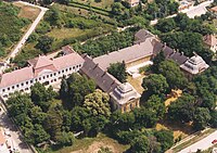 Podmaniczky Mansion in Aszód
 -
 Szentandráspart from above (Galgahévíz)
 -
 Schossberger Castle in Tura
 -
 Old Church in Hévízgyörk


See also[edit]
References[edit]
- ^ A KSH 2013. évi helységnévkönyve
- ^ népesség.com, "Aszódi járás népessége"
- ^ 4.1.6.1 A népesség nemzetiség szerint, 2011, (in Hungarian) [1]
- ^ 4.1.7.1 A népesség vallás, felekezet szerint, 2011, (in Hungarian) [2]
External links[edit]
| Towns (2) | ||
|---|---|---|
| Large villages (2) | ||
| Villages (7) | ||
47°39′00″N 19°29′00″E / 47.6500°N 19.4833°E
This Pest County location article is a stub. You can help Wikipedia by expanding it. |