
Atiu
 Satellite Image of Atiu | |
 | |
| Geography | |
|---|---|
| Location | Central-Southern Pacific Ocean |
| Coordinates | 19°59′S 158°07′W / 19.983°S 158.117°W |
| Archipelago | Cook Islands |
| Area | 26.9 km2 (10.4 sq mi) |
| Administration | |
| Demographics | |
| Population | 434 (2016)[1] |
| Ethnic groups | Polynesian |

Ātiu, also known as ʻEnuamanu (meaning land of the birds), is an island of the Cook Islands archipelago, lying in the central-southern Pacific Ocean. Part of the Nga-pu-Toru, it is 214 km (133 mi) northeast of Rarotonga. The population of the 26.9 square kilometres (10.4 sq mi) island has dropped by two-thirds in the last 50 years.
Geography
[edit]
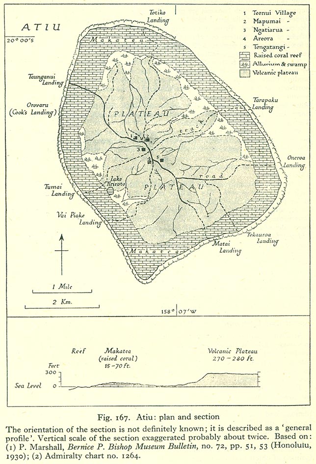
Atiu is a raised volcanic island surrounded by a reef from which rise 100-foot-high (30-metre) cliffs of fossilized coral (makatea).[2] The makatea cliff forms a zero-point-five-mile-wide (0.80-kilometre) ring round the island, creating a virtual plateau. Erosion of the inside of the ring has formed a dip of about 30 metres (98 feet) into fertile land, which gradually rises again to a central 70-metre-high (230-foot) flat-topped hill.[2] The low swampy land consists of taro plantations, marshes and a lake, Tiroto. This fertile area also grows bananas, citrus fruits, pawpaws, breadfruit and coconuts.
The island is surrounded by a 300-foot-wide (91-metre) fringing reef.[2] The makatea is honeycombed with caves, some of which have been used for burials.[3]
History
[edit]Polynesians are believed to have lived on Atiu since at least 900 or 1000 AD.[4] According to oral tradition, Atiu is named for the first man on the island, who was fathered by Tangaroa.[5] Other traditions identify various settlers, including Te Ariki-Mou-Taua, Mariri, and Nuku-kere-i-manu, as well as a visit by the navigator Ruatapu.[5] The island was unified in c.1760, and subsequently invaded and dominated neighbouring Mauke and Mitiaro.[5][6]
The first recorded European to arrive at Atiu was Captain Cook. He sighted the island on 31 March 1777, and made tentative contact with some of the people over the next few days.[5] In early 1823 the missionary J.M. Orsmond left two Boraboran teachers on the island. Later that year John Williams of the London Missionary Society arrived and converted the island's leader, Rongomatane Ngaakaara Ariki, to Christianity.[5] This resulted in the island's population being resettled in a single settlement in its centre.[7] Conversion saw Atiu's dominance of its neighbours fade.[8]
In the 1860s Ngamaru Rongotini Ariki, ariki of Atiu, Mauke and Mitiaro, married Makea Takau Ariki, a Rarotongan ariki. As a result, in 1871 Atiu became part of the Kingdom of Rarotonga. In 1888 it became a British protectorate as part of the Cook Islands Federation.[9] In 1901 it was annexed by New Zealand.[5] Post-annexation the island exported oranges, coffee and copra, but exports were disrupted by poor shipping, and collapsed in the 1950s.[10] The citrus industry was revived in the 1960s, but declined again in the 1970s.[11] Lack of economic opportunity had already begun to drive emigration to Rarotonga in the 1950s,[12] and the economic crisis of 1995 and 1996 and subsequent public sector reforms has led to the island's depopulation.[13]
Demographics
[edit]
Most human settlements are concentrated on the central hill. On 12 March 2003, the population of Atiu was 571, in five villages radiating out from the island's centre, giving the appearance of a human figure. The villages have essentially grown together into one since 1823. They represent the tapere subdivisions prior to European contact.[14] With their traditional names, the villages are:
- Teenui Village (Te-Kuru-Kava-Nui)
- Mapumai Village (Mapumai-Nui-O-Ruavari)
- Ngatiarua Village (Mokoero-Nui-O-Tautipa)
- Areora Village (Areora-Nui-Te-Are-O-Tangaroa)
- Tengatangi Village (Taturoa-I-Te-Puta-Marama)
Each of the five villages in Atiu – visitors may not distinguish one from the other – has a meeting house which is very important to them. They are well maintained and the villagers have pride in them. In these houses they conduct village meetings and community functions like welcoming and feeding visitors, selling of products. Educational courses are conducted in these houses and when a big group from overseas visit they could be accommodated in here for the time they are on the island.[15]
| Year | Pop. | ±% |
|---|---|---|
| 1906 | 918 | — |
| 1916 | 759 | −17.3% |
| 1926 | 933 | +22.9% |
| 1936 | 1,086 | +16.4% |
| 1951 | 1,270 | +16.9% |
| 1961 | 1,266 | −0.3% |
| 1966 | 1,327 | +4.8% |
| 1976 | 1,312 | −1.1% |
| 1986 | 957 | −27.1% |
| 1996 | 956 | −0.1% |
| 2001 | 623 | −34.8% |
| 2006 | 570 | −8.5% |
| 2011 | 480 | −15.8% |
| 2016 | 434 | −9.6% |
| Source:[1] | ||
Administratively, the small uninhabited island of Takutea, now a bird sanctuary, is considered part of Atiu.[16]
Culture
[edit]The Atiuans call themselves Toke-enua no Enuamanu ("worms of Enuamanu") because they were born on Atiu and hope to be buried there. There was once a custom on Atiu similar to that of New Zealand Māori of burying a newborn child's placenta under a newly planted tree. This is the origin of the Atiuan saying: "We come from the land and go back to the land."[17]
96% of the population identify themselves as Cook Islanders.[18] 49.6% identify themselves as affiliated with the Cook Islands Christian Church, 21.3% as Roman Catholic, and 13.9% as Seventh-day Adventist.[19]
A local custom is the tumunu or bush beer party. Brewing was introduced to the island by whalers, but the consumption of alcohol was banned by the missionaries and remained illegal until the 1980s, leading to a culture of secret brewing in the jungle.[20][21] Originally organised as a secret society, the tumunu is now marketed as a tourism experience.[22][23]
Economy
[edit]Atiu's economy is heavily government-supported, with 50% of the workforce employed by the public sector.[24] Following the collapse of the citrus industry and subsequent depopulation of the island, facilities are limited to a few shops, a lodge, and one motel.[24] There is some tourism, and Atiu is the second most-visited outer island after Aitutaki.[24] A new plant nursery was opened in 2020.[25]
Atiu is connected to the rest of the Cook Islands by Enua Airport and a wharf at Taunganui Harbour.
Previously powered by diesel generators, since 2018 it has been powered by a solar-battery power station.[26][27]
Coffee
[edit]Atiu has a long history of growing coffee. Missionaries established it commercially in the early 19th century. By 1865, annual exports of coffee from the Cook Islands amounted to 30,000 pounds. The islands' ariki (high chiefs) controlled the land used for planting and received most of the returns. The commoners often saw little if any reward for their labour. In the late 1890s, Rarotongan coffee production suffered due to a blight that affected the plants. Coffee production declined and had to rely more on crops from the outer islands Atiu, Mauke and Mangaia. World Wars I and II resulted in a further export reduction and eventual standstill.
In the 1950s the co-operative movement in the Cook Islands resulted in the re-establishment of coffee as a cash crop. On Atiu, under the supervision of New Zealand Resident Agent Ron Thorby and the Cook Islands Agriculture Department, new coffee plantations were established. The raw coffee was destined for export to New Zealand where it was processed and marketed.
By 1983, the coffee industry had collapsed. Government stepped back and left the plantations to their landowners. The poor financial return from selling their coffee to a Rarotongan company for processing had prompted the farmers to stop production except for their own private use. The plantations were overgrown with creepers.
Commercial coffee production was revived sometime in 1984, with the founding of Atiu Coffee Factory Ltd.[28] by German economist Juergen Manske-Eimke.[29] In 2012, the Atiu Coffee Factory managed 39 hectares (96 acres) of land and produced 4.5 tonnes of roasted beans.[30] In 2015 the coffee factory closed and was taken over by Atiu Island Coffee.[31]
Ecology
[edit]

Flora
[edit]The flora of Atiu can be divided into five ecological zones.[32] The pa tai (coast) and Rautuitui (upland makatea), are dominated by coconuts and Pandanus tectorius, with patches of Barringtonia asiatica, Elaeocarpus tonganus, and Hernandia moerenhoutiana.[33] The Puna (swampy lowlands) are cultivated for taro, with grasses and forests in the drier parts. The Rautuanue (slopes) and maunga (mountain) are dominated by Platycerium, Casuarina, and crops of pineapple and yams.[32]
In 2017 the Moko‘ero Nui Nature Reserve was established on the western side of the island, protecting 120 hectares of coastal forest.[34]
Fauna
[edit]Endemic birds include the Pacific imperial pigeon, chattering kingfisher, and lilac-crowned fruit dove.[35] The Atiu swiftlet or kopeka (Aerodramus sawtelli), a bird which uses echo-location, is found only on Atiu and nests inside Anatakitaki Cave. Subfossil remains show that the Polynesian ground dove, Polynesian imperial pigeon, and Kuhl's lorikeet (Rimatara lorikeet, Vini kuhlii) were all at one stage extant on Atiu before being extirpated.[36]
Because the island is free of black rats, it was chosen as a site for reintroduction of the Rarotonga monarch in 2001,[37] and Kuhl's lorikeet in 2007.[38] The latter has since become well-established, with a population of over 400 individuals.[39]
The common myna was introduced in 1915 in an effort to control the Coconut Stick-insect and has since become a major pest.[35] In 2009 an eradication campaign was launched, involving trapping, poisoning and shooting. The bird was eradicated from the island in 2014,[40] leading to an outbreak of stick insects in 2016.[41]
The island has been designated an Important Bird Area (IBA) by BirdLife International.[42][43]
See also
[edit]References
[edit]- ^ a b "Cook Islands 2016 Census Main Report" (PDF). Cook Islands Statistical Office. 2018. p. 46. Archived from the original (PDF) on 31 October 2020. Retrieved 19 August 2020.
- ^ a b c B. L. Wood (1967). "Geology of the Cook Islands". New Zealand Journal of Geology and Geophysics. 10 (6): 1437. doi:10.1080/00288306.1967.10423227.
- ^ "Attractions: Caves". Atiu Islands. 2018. Retrieved 8 February 2021.
- ^ Sear, D. A.; Allen, M. S.; Hassall, J. D.; Maloney, A. E.; Langdon, P. G.; Morrison, A. E.; Henderson ACG; MacKay, H.; Croudace, I. W.; Clarke, C.; Sachs, J. P.; MacDonald, G.; Chiverrell, R. C.; Leng, M. J.; Cisneros-Dozal, L. M.; Fonville, T.; Pearson, E. (16 June 2020). "Human settlement of East Polynesia earlier,incremental, and coincident with prolonged South Pacific drought" (PDF). Proceedings of the National Academy of Sciences. 117 (24): 8813–8819. Bibcode:2020PNAS..117.8813S. doi:10.1073/pnas.1920975117. PMC 7183181. PMID 32253300. Retrieved 8 February 2021.
- ^ a b c d e f Alphons M.J. Kloosterman (1976). Discoverers of the Cook Islands and the Names they Gave. Cook Islands Library and Museum. pp. 12–15. Retrieved 8 February 2021.
- ^ J. T. Large (1913). "Some notes on Atiu Island, Cook Group, South Pacific". Journal of the Polynesian Society. 22 (86): 67–76. Retrieved 8 February 2021.
- ^ Menzies, Brian John (1970). A study of a development scheme in a Polynesian community : the citrus replanting scheme on Atiu, Cook Islands (MA). Massey University. p. 23. hdl:10179/13651. Retrieved 8 February 2021.
- ^ Menzies (1970), p. 24-25.
- ^ "Protectorate Over the Cook's Group: The official ceremony performed". New Zealand Herald. Vol. XXV, no. 9227. 3 December 1888. p. 11. Retrieved 20 August 2020 – via Papers Past.
- ^ Menzies (1970), p. 31-33.
- ^ Alan Bollard (1979). Development Studies Centre Monograph no.15 : Agricultural project design and evaluation in an island community (PDF). Canberra: Australian National University. Retrieved 8 February 2021.
- ^ R. Gerard Ward (1961). "A note on population movements in the Cook Islands". Journal of the Polynesian Society. 70 (1): 1–10. Retrieved 9 February 2021.
- ^ Tisam, Jonah Nardu (2015). EMBRACING MANAGERIALISM IN A SMALL PACIFIC ISLAND STATE: A STUDY OF GOVERNANCE AND NEW PUBLIC MANAGEMENT OUTCOMES IN THE COOK ISLANDS FROM 2006–201 (PDF) (PhD). Auckland University of Technology. p. 39. Archived from the original (PDF) on 15 August 2017.
- ^ Atiu: An Island Community. editorips@usp.ac.fj. 1 January 1984. ISBN 9789820201637. Retrieved 2 May 2017 – via Google Books.
- ^ Evaroa, B. (2015) Atiu Online: Points of Interest. Presentation at the Atiu Online: Developing Destination Content – Digital Enablement workshop, Atiu, 23 October 2015.
- ^ pmoffice.gov.ck
- ^ Tatuava Tanga (1984). "Enua: The Island". In Vainerere Tangatapoto (ed.). Atiu: An Island Community. Suva: Institute of Pacific Studies. p. 2.
- ^ 2016 Census, Table 2.03.
- ^ 2016 Census, Table 2.04.
- ^ "Tumunu". Atiu Islands. Retrieved 8 February 2021.
- ^ Richard Deal (3 March 2020). "Tumunu, the Bush Beer Bar Tradition of Atiu, Cook Islands". In Nancy Hoalst-Pullen; Mark Patterson (eds.). The Geography of Beer. Springer, Cham. pp. 35–45. doi:10.1007/978-3-030-41654-6_4. ISBN 978-3-030-41653-9. S2CID 216398603.
- ^ Roger Malcolm (16 April 2017). "Bar review: The Walking Dead, Atiu, Cook Islands". New Zealand Herald. Retrieved 8 February 2021.
- ^ Gerard Hindmarsh (29 December 2018). "An island treasure like no other". Stuff. Retrieved 8 February 2021.
- ^ a b c "Island Profile: Atiu" (PDF). Ministry of Finance and Economic Management. Retrieved 8 February 2021.
- ^ Katrina Lintonbon (8 June 2020). "Growing to survive and thrive in the Pa Enua". Cook Islands News. Retrieved 8 February 2021.
- ^ "PM cuts ribbon to launch Mangaia power plant". Cook Islands News. 29 November 2018. Retrieved 8 February 2021.
- ^ "NZ company completes solar project in Cooks". RNZ. 22 July 2019. Retrieved 8 February 2021.
- ^ Atiu Coffee Factory – producers of organic gourmet coffee Archived 22 January 2012 at the Wayback Machine
- ^ "Atiu Coffee Factory: A Look Back". atiu-gourmet-coffee.com. Archived from the original on 3 March 2016. Retrieved 2 May 2017.
- ^ Jim Eagles (3 May 2012). "Atiu: Coffee revival in the Cook Islands". New Zealand Herald. Retrieved 24 July 2020.
- ^ "Coffee". Atiu Islands. 2018. Retrieved 24 July 2020.
- ^ a b Menzies (1970), p. 13-15.
- ^ Franklin, Janet; Merlin, Mark (1992). "Species-environment patterns of forest vegetation on the uplifted reef limestone of Atiu, Mangaia, Ma'uke and Miti'aro, Cook Islands" (PDF). Journal of Vegetation Science. 3 (1): 9. doi:10.2307/3235991. JSTOR 3235991. S2CID 30441399. Archived from the original (PDF) on 22 February 2019. Retrieved 8 February 2021.
- ^ "New Atiu nature reserve a huge gift to the future". Cook Islands News. 9 January 2017. Retrieved 9 February 2021.
- ^ a b Jessica Mitchell (2009). "The distribution and abundance of the common myna, Atiu, Cook Islands" (PDF). University of Leeds. p. 11. Retrieved 8 February 2021.
- ^ Steadman, David W. (1991). "Extinct and Extirpated Birds from Aitutaki and Atiu, Southern Cook Islands" (PDF). Pacific Science. 45 (4): 325–347. Retrieved 8 February 2021.
- ^ Peter de Graaf (4 November 2018). "Cook Islands: The Birdman of Atiu". New Zealand Herald. Retrieved 8 February 2021.
- ^ "Saved by one Queen and Brought Home by Another: Rimatara Lorikeet Returns to the Cook Islands". BirdLife International. 27 September 2007. Retrieved 8 February 2021.
- ^ "Ten years later, rare bird is well established on Atiu". Cook Islands News. 1 May 2017. Retrieved 20 August 2020.
- ^ "Final Push to Rid Atiu of Mynah Birds". Cook Islands News. 23 September 2014. Retrieved 8 February 2021.
- ^ "Birds gone, but stick insects are back". Cook Islands News. 4 May 2016. Retrieved 8 February 2021.
- ^ "Atiu". BirdLife Data Zone. BirdLife International. 2021. Retrieved 7 March 2021.
- ^ "Atiu, Aitutaki 'important bird areas'". Cook Islands News. 29 March 2012. Retrieved 9 March 2021.
Further reading
[edit]- Atiu, an Island Community: An Island Community. By Ngatupuna Kautai. Published by editorips@usp.ac.fj, 1984. ISBN 982-02-0163-2, ISBN 978-982-02-0163-7, 207 pages Books.Google.com
External links
[edit]- Atiu Island's website
- Atiu on the Cook Islands website
- Island map
- Seacology Atiu Island Project Seacology
| Northern chain | ||
|---|---|---|
| Southern chain - Nga-pu-Toru | ||
| Southern chain - other | ||
| International | |
|---|---|
| National | |