
Bagwai
Bagwai
Garin Danmadami | |
|---|---|
LGA and town | |
| Nickname: BGW | |
 Bagwai Location in Nigeria | |
| Coordinates: 12°09′28″N 8°08′09″E / 12.15778°N 8.13583°E | |
| Country | |
| State | Kano State |
| Area | |
| • Total | 405 km2 (156 sq mi) |
| Population (2006 census) | |
| • Total | 162,847 |
| Time zone | UTC+1 (WAT) |
| 3-digit postal code prefix | 701 |
| ISO 3166 code | NG.KN.BA |
 | |
Bagwai is a local government area in Kano State, Nigeria. Its headquarters is in the town of Bagwai.
It has an area of 405 km2 and had a population of 162,847 in the 2006 census. The third biggest dam in Kano State Watari Dam is located in Bagwai. The postal code of the area is 701.[1]
Climate
[edit]In Bagwai, the wet season is oppressive and largely cloudy, the dry season is partly gloomy, and it is hot year round. It rarely drops below 50°F or rises over 105°F throughout the year; instead, the average range of temperatures is 55°F to 100°F. March 16 to May 27 is the start of the 2.3-month hot season, which has daily highs that average more than 97°F. At 98°F on average for highs and 76°F on average for lows, May is the hottest month in Bagwai. The average daily high temperature during the 1.7-month mild season, which runs from December 6 to January 29, is less than 87°F. In Bagwai, January is the coldest month of the year, with an average low temperature of 56°F and high temperature of 85°F.[2][3]
Cloud
[edit]In Bagwai, there is a notable seasonal fluctuation in the average percentage of cloud cover throughout the year. Around November 10 to March 2, or 3.8 months, is when Bagwai has its clearest season. The sky is clear, mostly clear, or partly overcast 65% of the time in January, which is the clearest month of the year in Bagwai.[2][4]
In Bagwai, May is the cloudiest month of the year, with an average of 70% of the sky being cloudy or overcast. The cloudier portion of the year starts around March 2 and lasts for 8.2 months, ending around November 10.[4][2]


Wards
[edit]There are ten wards in Bagwai local government:
- Bagwai
- Dangada
- Gadanya
- Gogori
- Kiyawa
- Kwajale
- Rimin Dako
- Romo
- Sare-Sare
- Warure
- Tsakuwa
- Wuro Bagga
-
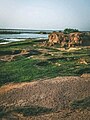
 Boat at Watari dam Bagwai
 -
-


References
[edit]- ^ "Post Offices- with map of LGA". NIPOST. Archived from the original on 7 October 2009. Retrieved 2009-10-20.
- ^ a b c "Bagwai Climate, Weather By Month, Average Temperature (Nigeria) - Weather Spark". weatherspark.com. Retrieved 2024-07-25.
- ^ "Weather forecast and conditions for Bagwai, Kano, Nigeria - The Weather Channel | weather.com". The Weather Channel. Retrieved 2024-07-25.
- ^ a b "Weather Forecast Bagwai - Nigeria (Kano) : free 15 day weather forecasts". Weather Crave. 2024-07-25. Retrieved 2024-07-25.
State capital: Kano | ||
| Local government areas |
|  |
This Kano State, Nigeria location article is a stub. You can help Wikipedia by expanding it. |