
Bangda Lake
| Bangda Lake | |
|---|---|
| Yeshil Kul | |
 Sentinel-2 image (2021) | |
 Bangda Lake | |
| Location | Rutog County, Ngari Prefecture, Tibet Autonomous Region, China |
| Coordinates | 34°56′56″N 81°34′16″E / 34.94889°N 81.57111°E |
| Catchment area | 3,314.5 km2 (1,300 sq mi) |
| Basin countries | China |
| Max. length | 15 km (9 mi) |
| Max. width | 9.7 km (6 mi) |
| Surface area | 106.5 km2 (0 sq mi) |
| Surface elevation | 4,902 m (16,083 ft) |
| References | [1] |
Bangda Lake (Tibetan: པང་བཏགས་མཚོ, Wylie: pang btags mtsho, THL: pang tak tso; Chinese: 邦达错; pinyin: Bāngdá Cuò),[a] formerly called Yeshil Kul,[2][b] is a glacial lake in Ngari Prefecture in the northwest of the Tibet Autonomous Region of China. It lies south of the western Kunlun Mountains, only a few kilometres to the southeast of Guozha Lake (Lake Lighten).[2] Located at an altitude of 4902 metres, it covers an area of 106 square kilometres with a maximum depth of 21.6 metres and has a drainage basin containing 90 glaciers.[3]
Location
[edit]Located at an elevation of 4,902 metres (16,083 ft), the Bangda Lake covers an area of 106 square kilometres with a maximum depth of 21.6 metres and contains 90 glaciers.[4]
Yeshil Kul is located along an ancient travel route between Ladakh and Khotan via the Keriya Pass.[5][6] The route runs along the Longmu Co fault up to Yeshil Kul, and then heads north to the Keriya Pass, after which the valleys of the Iksu, Polu and Keriya rivers are followed.
A "Xinjiang–Tibet Highway" was laid by the People's Republic of China between the Polu town and the vicinity of the Bangda Lake during 1950–1951, prior to its annexation of Tibet.[7][8] Jeep tracks were then made over the relatively flat, hard terrain of the Longmu Co fault, leading to Rudok. A regular jeep traffic had commenced by 1953.[9] China has recently constructed a highway that runs along the fault connecting the G219 and G216 highways.[10]
Maps
[edit]-
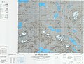 Map including Yahsierh Tso (Yeshil Kul)
 -
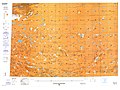 Map including Bangdag Co


Notes
[edit]References
[edit]- ^ Sumin, Wang; Hongshen, Dou (1998). Lakes in China. Beijing: Science Press. p. 416. ISBN 7-03-006706-1.
- ^ a b Hedin, Sven (1999), Trans Himalayas - Discoveries and Adventures in Tibet - 3 Vols., Asian Educational Services, pp. 19–, ISBN 978-81-206-1416-1
- ^ Chaohai, Liu; Shijie, Li; Yafeng, Shi (2017). "Glacial and lake fluctuations in the area of the west Kunlun mountains during the last 45 000 years" (PDF). Annals of Glaciology. 16. Table 1. doi:10.3189/1992AoG16-1-79-84. ISSN 0260-3055.
- ^ Li, Shijie; Shi, Yafeng (1992). "Glacial and lake fluctuations in the area of the west Kunlun mountains during the last 45 000 years". Annals of Glaciology. 16: 79–84. doi:10.3189/1992AoG16-1-79-84. ISSN 0260-3055.
- ^ "Journey of Carey and Dalgleish in Chinese Turkistan and Northern Tibet and General Prejevalsky on the Orography of Northern Tibet", Royal Geographical Society (Great Britain), Supplementary Papers, J. Murray, 1893, p. 11 – via archive.org
- ^ Grenard, Fernand (2010) [1904], Tibet, Hutchinson & Co / Gyan Publishing House, pp. 18–19, ISBN 978-81-212-1024-9
- ^ Dillon, Michael (2014), Xinjiang and the Expansion of Chinese Communist Power: Kashgar in the early twentieth century, Routledge, pp. 227–229, ISBN 978-0-415-58443-2 – via archive.org,
By May 1951, the construction of the 208.5 kilometre road had been completed at the cost of a dozen deaths and injuries to over 100 soldiers
- ^ Keriya trail, OpenStreetMap, retrieved 14 November 2022.
- ^ Mullik, B. N. (1971), My Years with Nehru: The Chinese Betrayal, Allied Publishers, p. 197 – via archive.org,
In 1953, we reported that the jeep track to Rudok had been completed and regular jeep traffic had commenced. It was because of these troop movements and the road building activity that the Chinese had refused to allow a trade mart to be opened at Rudok.
- ^ Kongka La Highway, OpenStreetMap, retrieved 14 November 2022.
| County-level divisions |  | |
|---|---|---|
| Towns and villages | ||
| Geography | ||
| Landmarks | ||
This Ngari Prefecture, Tibet location article is a stub. You can help Wikipedia by expanding it. |