
Batuliyska reka
| Blato | |
|---|---|
 | |
| Location | |
| Country | Bulgaria |
| Physical characteristics | |
| Source | |
| • location | Murgash, Balkan Mountains |
| • coordinates | 42°49′19.92″N 23°38′49.92″E / 42.8222000°N 23.6472000°E |
| • elevation | 1,366 m (4,482 ft) |
| Mouth | |
• location | Iskar |
• coordinates | 42°48′2.16″N 23°21′48.96″E / 42.8006000°N 23.3636000°E |
• elevation | 496 m (1,627 ft) |
| Length | 40 km (25 mi) |
| Basin size | 256 km2 (99 sq mi) |
| Basin features | |
| Progression | Iskar→ Danube→ Black Sea |
The Batuliyska reka (Bulgarian: Батулийска река) is a 40 km-long river in western Bulgaria, a right tributary of the river Iskar.[1]
The river takes its at an altitude of 1,366 m, in the Murgash division of the Balkan Mountains. It initially flows north and after receiving its tributary the Elovitsa, it turns west until its mouth. It flows in a deep forested valley between the Golema Planina to the north and the Sofiyska Planina to the south, both divisions of the Balkan Mountains. Downstream of the village of Batulia its valley widens. The river flows into the Iskar at an altitude of 496 m at the village of Rebrovo.[1]
Its drainage basin covers a territory of 256 km2 or 3.0% of Iskar's total.[1] The Batuliyska reka has high water in March–June and low water in July–October. The average annual discharge at Batulia is 2.7 m3/s.[1]
The Batuliyska reka flows entirely in Sofia Province. There are four villages along its course: Yablanitsa, Bakyovo, Batulia and Rebrovo, all of them in Svoge Municipality.
Gallery
[edit]-
 The river at Yablanitsa
 -
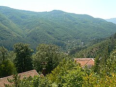 The river valley at Batulia


Citations
[edit]- ^ a b c d Geographic Dictionary of Bulgaria 1980, pp. 32–33
References
[edit]- Мичев (Michev), Николай (Nikolay); Михайлов (Mihaylov), Цветко (Tsvetko); Вапцаров (Vaptsarov), Иван (Ivan); Кираджиев (Kiradzhiev), Светлин (Svetlin) (1980). Географски речник на България [Geographic Dictionary of Bulgaria] (in Bulgarian). София (Sofia): Наука и култура (Nauka i kultura).