
Belo sur Mer
Belo sur Mer | |
|---|---|
 main road of Belo sur Mer | |
 Belo sur Mer Location in Madagascar | |
| Coordinates: 20°44′S 44°0′E / 20.733°S 44.000°E | |
| Country | |
| Region | Menabe |
| District | Morondava |
| Elevation | 5 m (16 ft) |
| Population (2001)[2] | |
• Total | 8,000 |
| Time zone | UTC3 (EAT) |
| Postal code | 619 |
Belo sur Mer is a rural municipality in Madagascar. It belongs to the district of Morondava, which is a part of Menabe Region. The population of the commune was estimated to be approximately 8,000 in 2001 commune census.[2]
Primary and junior level secondary education are available in town. It is also a site of industrial-scale mining. The majority 60% of the population of the commune are farmers. The most important crop is maize, while other important products are sweet potatoes and lima beans. Industry provides employment for 10% of the population. Additionally fishing employs 30% of the population.[2]
Economy
[edit]Belo sur mer is well known for its boatbuilders of traditional wooden dhows. There are also Salt evaporation ponds in the commune.[3]
National Parks
[edit]Belo sur Mer is the entry point to the Kirindy Mitea National Park.
Gallery
[edit]-
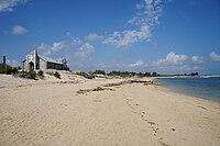 Beach & church
 -
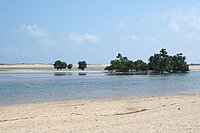 Mangroves
 -
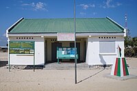 Town hall
 -
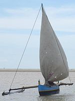 Outrigger boat


References
[edit]- ^ Estimated based on DEM data from Shuttle Radar Topography Mission
- ^ a b c "ILO census data". Cornell University. 2002. Retrieved 2008-03-11.
- ^ priori - Belo sur Mer (in French)
Capital: Morondava | ||
| Belo sur Tsiribihina (16) (608) |  | |
| Mahabo (12) (615) | ||
| Manja (7) (616) | ||
| Miandrivazo (16) (617) | ||
| Morondava (6) (619) | ||
5 districts; 57 communes | ||