Biržulis
| Lake Biržulis | |
|---|---|
| Coordinates | 55°46′N 22°26′E / 55.767°N 22.433°E |
| Primary outflows | Virvytė |
| Basin countries | Lithuania |
| Max. length | 3.6 km (2.2 mi) |
| Max. width | 1.3 km (0.81 mi) |
| Surface area | 4.7 km2 (1.8 sq mi) |
| Average depth | 0.91 m (3 ft 0 in) |
| Max. depth | 2.4 m (7 ft 10 in) |
| Islands | 2 |
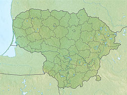
Lake Biržulis is a lake in the Telšiai District of western Lithuania. It has a maximum length in the north-south direction of 3.6 km. The lake has two islands, Spiginas and Duonkalnis, which have yielded Mesolithic and Neolithic burials including the Mesolithic grave of the "Duonkalnis shaman".
Archaeology[edit]
The island site of Spiginas have yielded four burials dating from 7780 BP to 4080 BP.[1] The grave pits were shallow and filled with red ochre, and yielded grave goods of perforated pendants of elk and boar teeth.[2]
The island site of Duonkalnis (also Donkalnis) has yielded around 14 graves.[2] The most remarkable of these is the double grave of the Duonkalnis "shaman".[3] A young man was buried together with a woman in a grave sprinkled with red ochre beside a ritual hearth also sprinkled with ochre.[4] His body was adorned with 57 amulets including moose teeth strung across his head and wild boar tusks on each of his eyes.[4] The body is now on display in the Archaeology section of the National Museum of Lithuania in Vilnius.[4]
References[edit]
- ^ Julku, Kyösti; Wiik, Kalevi (2000). The Roots of Peoples and Languages of Northern Eurasia. Societas Historiae Fenno-Ugricae. p. 119.
- ^ a b Kiaupa, Zigmantas (2000). The History of Lithuania: Before 1795. Lietuvos Istorijos institutas. p. 20.
- ^ Griciuvienė, Eglė (2000). Prehistoric Lithuania: Archaeological Exposition Guide. National Museum of Lithuania. p. 26.
- ^ a b c "Museums: Prehistoric Lithuania a New Museum Dedicated to the Past". Draugas News. 15 September 2000.

