Blackford, Cumbria
Appearance
| Blackford | |
|---|---|
| Village | |
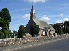
 St. John the Baptist's church, Blackford | |
Location in the former City of Carlisle district Location within Cumbria | |
| OS grid reference | NY396621 |
| Civil parish | |
| Unitary authority | |
| Ceremonial county | |
| Region | |
| Country | England |
| Sovereign state | United Kingdom |
| Post town | CARLISLE |
| Postcode district | CA6 |
| Dialling code | 01228 |
| Police | Cumbria |
| Fire | Cumbria |
| Ambulance | North West |
| UK Parliament | |
Blackford is a village in Cumbria, England, close to Gretna, Scotland.[1][2]
Etymology
[edit]Blackford means what it says, a black ford or river-crossing. However, unlike other places of the name, it is a mix of Old English and Old Norse: the first element is Old English blǣc "black", while the second element is Old Norse vathr / vaőr, ford, river crossing, which usually occurs as -wath in place-names with this element (e.g. Wath upon Dearne). The name was recorded as Blakiwaith in 1165.
See also
[edit]References
[edit]- ^ Ordnance Survey: Landranger map sheet 85 Carlisle & Solway Firth (Gretna Green) (Map). Ordnance Survey. 2012. ISBN 9780319231579.
- ^ "Ordnance Survey: 1:50,000 Scale Gazetteer" (csv (download)). www.ordnancesurvey.co.uk. Ordnance Survey. 1 January 2016. Retrieved 30 January 2016.
Wikimedia Commons has media related to Blackford, Cumbria.


