Boitron, Orne
Boitron | |
|---|---|
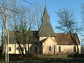
 The church in Boitron | |
| Coordinates: 48°33′40″N 0°15′50″E / 48.5611°N 0.2639°E | |
| Country | France |
| Region | Normandy |
| Department | Orne |
| Arrondissement | Alençon |
| Canton | Sées |
| Government | |
| • Mayor (2020–2026) | Patrick Fleuriel[1] |
| Area 1 | 13.35 km2 (5.15 sq mi) |
| Population (2021)[2] | 347 |
| • Density | 26/km2 (67/sq mi) |
| Time zone | UTC+01:00 (CET) |
| • Summer (DST) | UTC+02:00 (CEST) |
| INSEE/Postal code | 61051 /61500 |
| Elevation | 152–224 m (499–735 ft) (avg. 225 m or 738 ft) |
| 1 French Land Register data, which excludes lakes, ponds, glaciers > 1 km2 (0.386 sq mi or 247 acres) and river estuaries. | |
Boitron (French pronunciation: [bwatʁɔ̃] ⓘ) is a commune in the Orne department in northwestern France.[3]
Population[edit]
| Year | Pop. | ±% p.a. |
|---|---|---|
| 1968 | 297 | — |
| 1975 | 262 | −1.78% |
| 1982 | 263 | +0.05% |
| 1990 | 219 | −2.26% |
| 1999 | 215 | −0.20% |
| 2009 | 342 | +4.75% |
| 2014 | 338 | −0.24% |
| 2020 | 358 | +0.96% |
| Source: INSEE[4] | ||
Notable buildings and places[edit]
National heritage sites[edit]
- Domaine de Beaufossé is an 18th century House and Estate, declared as a Monument historique in 2001.[5] The gardens of the Estate were landscaped by Henri and Achille Duchêne.[5] The Estate grounds are shared with the neighbouring commune of Essay.[6]
See also[edit]
References[edit]
- ^ "Répertoire national des élus: les maires". data.gouv.fr, Plateforme ouverte des données publiques françaises (in French). 2 December 2020.
- ^ "Populations légales 2021". The National Institute of Statistics and Economic Studies. 28 December 2023.
- ^ "Commune de Boitron (61051) − COG". www.insee.fr.
- ^ Population en historique depuis 1968, INSEE
- ^ a b "Domaine de Beaufossé (également sur commune de Boitron) à Essay - PA61000055". monumentum.fr.
- ^ "Domaine de Beaufossé à Boitron - PA61000054". monumentum.fr.
Wikimedia Commons has media related to Boitron (Orne).


