Brookthorpe
| Brookthorpe | |
|---|---|
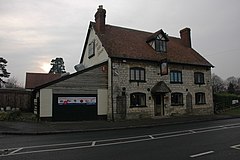
 Fagin's, Brookthorpe | |
Location within Gloucestershire | |
| OS grid reference | SO837121 |
| Civil parish | |
| District | |
| Shire county | |
| Region | |
| Country | England |
| Sovereign state | United Kingdom |
| Police | Gloucestershire |
| Fire | Gloucestershire |
| Ambulance | South Western |
Brookthorpe is a village and former civil parish, now in the parish of Brookthorpe-with-Whaddon, in the Stroud district, in the county of Gloucestershire, England. In 1931 the parish had a population of 194.[1] It has a church called St Swithun's Church.
History[edit]
The name "Brookthorpe" means 'Brook outlying hamlet'.[2] Brookthorpe was recorded in the Domesday Book as Brostorp.[3]
On 1 April 1935 the parish of Whaddon was merged with Brookthorpe,[4] on 3 July 1956 the parish was renamed "Brookthorpe with Whaddon".[5]
References[edit]
- ^ "Population statistics Brookthorpe With Whaddon CP/AP through time". A Vision of Britain through Time. Retrieved 6 December 2022.
- ^ "Brookthorpe Key to English Place-names". The University of Nottingham. Retrieved 19 July 2020.
- ^ "Gloucestershire A-F". The Domesday Book Online. Retrieved 19 July 2020.
- ^ "Gloucester Registration District". UKBMD. Retrieved 6 December 2022.
- ^ "Gloucester Rural Registration District". UKBMD. Retrieved 6 December 2022.
External links[edit]
![]() Media related to Brookthorpe at Wikimedia Commons
Media related to Brookthorpe at Wikimedia Commons

