
Char Kaman
| Char Kaman | |
|---|---|
| Type | Arch |
| Area | Old City, Hyderabad |
| Founder | Muhammad Quli Qutb Shah |
| Built | 1592 |
| Architect | Mir Momin Astrawadi |
| Architectural style(s) | Indo-Islamic architecture |
| Owner | Government of Telangana |

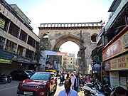
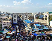
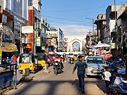
Char Kaman (literally "meaning four gates") are four historical structures in Hyderabad, India.[1] It is located near Charminar.[2] After the completion of Charminar, at about 75m feet to its north, four lofty arches known as Charkaman were built in 1592 by the Qutb Shahi dynasty along with Gulzar Houz.[3]
The names of the four arches are Charminar Kaman, Machli Kaman, Kali Kaman and Sher-e-Batil-Ki-Kaman.[4] The arches are fifty feet high, and demarcate an open square, in front of which a Qutb Shahi palace once existed. Scholar Omar Khalidi notes that the Char Kaman conceptually resembles the Registan constructed in Samarqand, Uzbekistan by the Timurids.[5]

In 1858, the monument was rehabilitated by the fifth Nizam of Hyderabad, Afzal-ud-Daulah.[6]
Charkaman is notified as a heritage structure by INTACH[7]
-
 Machli Kaman (North)
 -
 Sher-e-Batil-Ki-Kaman (West)
 -
 Charminar Kaman (South)
 -
 Kali Kaman (East)


References
[edit]- ^ Henry, Nikhila (10 July 2011). "Char kaman in Old City faces monumental neglect - Times Of India". Times of India. Retrieved 5 September 2011.
- ^ "Andhra Pradesh / Hyderabad News : Charminar pedestrianisation a far cry?". The Hindu. Chennai, India. 1 July 2010. Archived from the original on 7 July 2010. Retrieved 5 September 2011.
- ^ Bilgrami, Syed Ali Asgar (1992). Landmarks of the Deccan: A Comprehensive Guide to the Archaeological Remains of the City and Suburbs of Hyderabad. Asian Educational Services. ISBN 9788120605435.
- ^ "Glory of the gates". The Hindu. Chennai, India. 10 March 2004. Archived from the original on 1 February 2005. Retrieved 5 September 2011.
- ^ Khalidi, Omar (2008). A guide to architecture in Hyderabad, Deccan, India. Aga Khan Program for Islamic Architecture, MIT Libraries. pp. 5 & 7. OCLC 233637198.
- ^ "Nineteenth-Century Hyderabad: Re-Scripting Urban Heritage", The City in the Islamic World (2 vols.), BRILL, p. 591, 1 January 2008, retrieved 11 March 2022
- ^ "HERITAGE - SITES". INTACH Hyderabad Chapter. Archived from the original on 6 October 2011. Retrieved 5 September 2011.