
Corona, Alabama
Corona, Alabama | |
|---|---|
 Corona  Corona | |
| Coordinates: 33°42′30″N 87°28′10″W / 33.70833°N 87.46944°W | |
| Country | United States |
| State | Alabama |
| County | Walker |
| Elevation | 325 ft (99 m) |
| Time zone | UTC-6 (Central (CST)) |
| • Summer (DST) | UTC-5 (CDT) |
| Area code(s) | 205, 659 |
| GNIS feature ID | 116660[1] |
Corona is an unincorporated community in Walker County, Alabama, United States. Corona is located on Alabama State Route 18, 4.6 miles (7.4 km) west of Oakman.
History[edit]
Corona was founded in the 1880s after the Corona Coal Company opened mines here.[2] The first coal shipped from Walker County by rail came from the Corona mines.[3] A post office operated under the name Corona from 1884 to 1957.[4]
Notes[edit]
- ^ "Corona". Geographic Names Information System. United States Geological Survey, United States Department of the Interior.
- ^ Foscue, Virginia (1989). Place Names in Alabama. Tuscaloosa: The University of Alabama Press. p. 40. ISBN 0-8173-0410-X.
- ^ Armes, Ethel (1972). The Story of Coal and Iron in Alabama. Birmingham: The Book-Keepers Press. p. 502.
- ^ "Walker County". Jim Forte Postal History. Archived from the original on July 3, 2015. Retrieved November 30, 2015.
Municipalities and communities of Walker County, Alabama, United States | ||
|---|---|---|
| Cities | 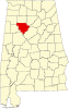 | |
| Towns | ||
| Unincorporated communities | ||
| Footnotes | ‡This populated place also has portions in an adjacent county or counties | |
This Walker County, Alabama state location article is a stub. You can help Wikipedia by expanding it. |