Cumsingmoon
Appearance
| Cumsingmoon | |||||||||||
|---|---|---|---|---|---|---|---|---|---|---|---|
 | |||||||||||
| Traditional Chinese | 金星門港 | ||||||||||
| Simplified Chinese | 金星门港 | ||||||||||
| Literal meaning | Gate of Venus harbour | ||||||||||
| |||||||||||
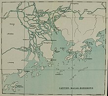
Cumsingmoon or Jinxingmen (Chinese: 金星门港) is an anchorage in Zhuhai, Guangdong, on the southern coast of China, within the Pearl River estuary and close to the former European colonies of Macao and Hong Kong.
In the early years of British Hong Kong in the 1840s, Cumsingmoon, together with Nan'ao, was home to an informal "counter-colony" jointly managed by opium merchants and local Chinese officials, helping traders to evade the colonial administration.[1] In 1845, this settlement comprised a self-governing community of 5,000 Chinese and European traders.[2]
El Piñal, a port granted to Spain by the Ming dynasty in 1598–1600, has speculatively been identified with Cumsingmoon.[3]
References[edit]
- ^ Munn, Christopher (2009). Anglo-China: Chinese People and British Rule in Hong Kong, 1841–1880 (2nd ed.). Hong Kong: Hong Kong University Press. p. 43. ISBN 9789622099517.
- ^ Munn 2009, p. 385, n. 99.
- ^ Crossley, John (2011). Hernando de los Ríos Coronel and the Spanish Philippines in the Golden Age. Farnham and Burlington: Ashgate. p. 54. ISBN 9781409425649.
Further reading[edit]
- Stasko, Thomas McTernan (2013). Moving through the gate of Venus: The history of Cumsingmoon and the coolie trade, 1849–54 (MA thesis). University of Macau.
22°22′53.1″N 113°37′31.1″E / 22.381417°N 113.625306°E
