Dănceni
Dănceni | |
|---|---|
Commune and village | |
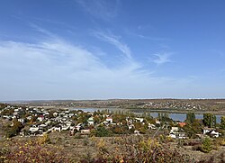
 A view across the lake, towards the north. | |
| Coordinates: 46°58′N 28°42′E / 46.967°N 28.700°E | |
| Country | |
| District | Ialoveni District |
| First written mention | 16 April 1617 |
| Area | |
| • Total | 8 sq mi (20 km2) |
| Elevation | 466 ft (142 m) |
| Population | |
| • Total | 2,406 |
| • Density | 310/sq mi (120/km2) |
| Time zone | UTC+2 (EET) |
| • Summer (DST) | UTC+3 (EEST) |
| Area code | 268-34 |
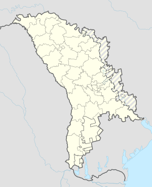
Dănceni (Romanian pronunciation: [dənˈt͡ʃenʲ]) is a village in Ialoveni District, Moldova.[2] It is located on the bank of a retention basin called Lake Danceni. The village of Dănceni is located 15 km from the capital of the Republic of Moldova, Chișinau, in the southwest direction. It borders the Suruceni, Chișinau, Ialoveni, Sociteni and Ruseștii Noi localities.
In the locality, there is a vocational school (ȘP no. 11, trades: locksmiths, welders, masons, tractor drivers, cooks), the "Alexandrina Rusu" gymnasium, the "Albinuța" kindergarten, the "Andrei Vartic" Public Library, a medical center, fish farms and forestry and a poultry farm. There is also a church called "Saint Demetrius", Romanian: Sfântul Dumitru.
History and etymology[edit]
The name of the locality comes from the name of the boyar Danciu, whose estate would have been located at this particular place.
The first documented mention of the locality is the act of 16 April 1617 (7125): "Ispisoc de la Radu Vodă. adecă al nostru credincios cinstit boiarin, dumnealui Ureche marile vornic m-am milostivit domnia me cu o asabită a noastră milă dumnezească, am dat și am întărit a lui dripte ocine și moșii, cumpărături și danii domnești, toate satile care are în țara domniei mele și de moșie de cumpărături și de danie dintr-a lui dripte drese mărturii ci-au avut dela alții domni mai dinainte (urmează un șir de sate și moșii din Moldova și Bucovina)... și satul Dancini pe Ișnovăț și partea lui din satul Culii din Ișnovăț...".[3]
The retention basin now present in the valley below Danceni was a project carried out by the Soviet planners in the late 1980s to curb flooding problems and create a large water source for farming. There was a small pond at the bottom of the valley before, near the Ișnovăț river, but it was only 5 ha and had a depth of 1.5 m. Most people were relocated from the old village, now underneath the lake, to a higher elevation, which is the current village. This started in 1974, with the construction of the dam, and finished in 1980. Around the same time, the construction of the new "Alexandrina Rusu" gymnasium, was also completed. [4]
In 1980, the Olympic flame was carried through many villages in Moldova on its way to Moscow for the Summer Olympics, and it passed by Dănceni on what is now known as "Olympic Street", Romanian: "Strada Olimpicilor". 368 Moldovan athletes carried the torch at some point on their way to Moscow.[5][6]

In the late 1980s, a Soviet plan to construct a headquarters for vinicultural purposes was carried out. However, this 75 m building was unfinished and now stands as a decaying concrete structure on the hill opposite Dănceni. It is frequently used by rope jumpers, but was also previously used as a place to train firefighters.[7]
In 1974, 1978 and 1980, archaeological excavations were carried out in Dănceni, and a settlement from the Middle Bronze Age and from the 5th-6th century was discovered. It was found that the Dănceni II necropolis is among the largest burial sites known in the Republic of Moldova, where 405 human burials were discovered, the largest part belonging to the Roman period, being attributed to the culture Sântana Mureș-Cerneahov from the 3rd-4th centuries.[3][4]

Geography[edit]
Dănceni is located on the bank of the retention basin, Lake Danceni, which is located in the Ișnovăț river valley. The lake has a capacity of 4 million m3 and a surface area of 2.2 km2.
The relief of the village was formed after the regression of the Sarmatian Sea, which disappeared about 5 million years ago. It is situated on a broad hill that rises steeply from the north, and slopes towards the south. The highest elevation near the forest is 220 meters, while the lowest near Poiana Pinului is 80 meters.

Notable people[edit]
- Anatolii Buruian
- Teodor Neaga, member Sfatul Țării
- Andrei Vartic
References[edit]
- ^ Results of Population and Housing Census in the Republic of Moldova in 2014: "Characteristics - Population (population by communes, religion, citizenship)" (XLS). National Bureau of Statistics of the Republic of Moldova. 2017. Retrieved 2017-05-01.
- ^ Clasificatorul unităților administrativ-teritoriale al Republicii Moldova (CUATM) (in Romanian)
- ^ a b "copy from archive (in Romanian)". Archived from the original on 2008-05-04. Retrieved 2010-04-14.
- ^ a b "FOTO Complexul arheologic Dănceni: 50 de ani de la demararea cercetărilor de teren". www.moldpres.md. Retrieved 2024-05-08.
- ^ Răileanu, Diana (2020-07-10). "Flacăra Olimpiadei din 1980 încă mai pâlpâie pe traseul ei moldav". Radio Europa Liberă (in Romanian). Retrieved 2024-05-08.
- ^ "Way: Strada Olimpicilor (614686918)". OpenStreetMap. 2024-01-27. Retrieved 2024-05-08.
- ^ "Un „zgârie-nori", părăsit de două decenii, riscă să se prăbușească oricând". Stiri de ultima ora din Moldova - Ultimele stiri Timpul.md (in Romanian). 2014-07-07. Retrieved 2024-05-08.

