Darlington Historic District
Appearance
Darlington Historic District | |
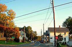
 Main street in Darlington, 2011 | |
| Location | Main St., Shuresville Rd., Quaker Ln., Richmond Ave., and Trappe Church Rd., Darlington, Maryland |
|---|---|
| Coordinates | 39°38′23″N 76°12′3″W / 39.63972°N 76.20083°W |
| Area | 250 acres (100 ha) |
| Architect | Cope, Walter; et al. |
| Architectural style | Late Victorian, Art Deco, English Gothic Revival |
| NRHP reference No. | 87001571[1] |
| Added to NRHP | September 10, 1987 |
Darlington Historic District is a national historic district at Darlington, Harford County, Maryland, United States. It includes approximately 100 small-scale structures in the village of Darlington. They include four churches including the Darlington United Methodist Church and the Deer Creek Friends Meetinghouse, a dozen shops and stores, barns/garages, meathouses, chicken houses, and other outbuildings, a lodge hall, a grammar school, a cemetery, and three working farms. They date particularly from the late 19th century through the early 20th century.[2]
It was added to the National Register of Historic Places in 1987.[1]
Gallery
[edit]-
A photograph of the village of Darlington on Main Street in the 1950s.
-
A photograph of the village of Darlington looking northeast from Bailey's Corner (currently the intersection of Shuresville Road and Route 161, or Main Street, and Kirk Road).
References
[edit]- ^ a b "National Register Information System". National Register of Historic Places. National Park Service. July 9, 2010.
- ^ Christopher Weeks (1986). "National Register of Historic Places Registration: Darlington Historic District" (PDF). Maryland Historical Trust. Retrieved July 20, 2017.
External links
[edit]- Darlington Historic District, Harford County, including photo dated 2000, at Maryland Historical Trust
- Boundary Map of the Darlington Historic District, Harford County, at Maryland Historical Trust


