
Dirkshorn
Dirkshorn | |
|---|---|
Village | |
 Former town hall | |
 Dirkshorn Location in the Netherlands  Dirkshorn Location in the province of North Holland in the Netherlands | |
| Coordinates: 52°45′N 4°47′E / 52.750°N 4.783°E | |
| Country | Netherlands |
| Province | North Holland |
| Municipality | Schagen |
| Area | |
| • Total | 10.17 km2 (3.93 sq mi) |
| Elevation | −0.4 m (−1.3 ft) |
| Population (2021)[1] | |
| • Total | 1,550 |
| • Density | 150/km2 (390/sq mi) |
| Time zone | UTC+1 (CET) |
| • Summer (DST) | UTC+2 (CEST) |
| Postal code | 1746[1] |
| Dialing code | 0224 |
Dirkshorn (West Frisian: Durkshorn) is a town in the Dutch province of North Holland and the region of West-Frisia. It is a part of the municipality of Schagen, and lies about 9 km north of Heerhugowaard.
The village was first mentioned in 1573 as Dierickshorn, and means "corner of Dierick (person)".[3] Dirkshorn is a dike village which developed in the Late Middle Ages.[4]
The Dutch Reformed church is a Gothic Revival church which was built in 1868 to replace the 1659 church.[4]
Gallery
[edit]-
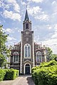 Dutch Reformed church
 -
 Farm in Dirkshorn


References
[edit]- ^ a b c "Kerncijfers wijken en buurten 2021". Central Bureau of Statistics. Retrieved 1 May 2022.
two entries
- ^ "Postcodetool for 1746AA". Actueel Hoogtebestand Nederland (in Dutch). Het Waterschapshuis. Retrieved 1 May 2022.
- ^ "Dirkshorn - (geografische naam)". Etymologiebank (in Dutch). Retrieved 1 May 2022.
- ^ a b Ronald Stenvert & Saskia van Ginkel-Meester (2006). "Dirkshorn" (in Dutch). Zwolle: Waanders. Retrieved 1 May 2022.
Wikimedia Commons has media related to Dirkshorn.
| Authority control databases: Geographic |
|---|
This North Holland location article is a stub. You can help Wikipedia by expanding it. |