
Draft:Ras Ash
| Draft article not currently submitted for review.
This is a draft Articles for creation (AfC) submission. It is not currently pending review. While there are no deadlines, abandoned drafts may be deleted after six months. To edit the draft click on the "Edit" tab at the top of the window. To be accepted, a draft should:
It is strongly discouraged to write about yourself, your business or employer. If you do so, you must declare it. Where to get help
How to improve a draft
You can also browse Wikipedia:Featured articles and Wikipedia:Good articles to find examples of Wikipedia's best writing on topics similar to your proposed article. Improving your odds of a speedy review To improve your odds of a faster review, tag your draft with relevant WikiProject tags using the button below. This will let reviewers know a new draft has been submitted in their area of interest. For instance, if you wrote about a female astronomer, you would want to add the Biography, Astronomy, and Women scientists tags. Editor resources
Last edited by LukasSimeone (talk | contribs) 5 seconds ago. (Update) |
Ras Ash
راس أش (Arabic) | |
|---|---|
 Small mountain village located in the Hajar Mountains (UAE) | |
| Nickname: Ras al Ghash | |
 Ras Ash Location of Ras Ash within the UAE | |
| Coordinates: 25°58′04″N 56°10′04″E / 25.96778°N 56.16778°E | |
| Country | |
| Emirate | |
| Area | |
| • Total | 0.25 km2 (0.10 sq mi) |
| Elevation | 1,450 m (4,757 ft) |
| Time zone | UTC+04:00 |
Ras Ash (Arabic: راس أش, romanized: Ras Ash), also known as Ras al Ghash, is a small agricultural and livestock village, located at 1,450 m altitude, northeast of the United Arab Emirates (UAE), in the Al Hajar Mountains, Emirate of Ras al Khaimah.
The village has about 15 houses, huts and stone cabins; corrals and terraces supported by dry stone walls, without mortar, which allow water and soil to be retained, destined for pastures and other agricultural uses; pipelines to collect runoff water; sheepfolds; and some other constructions in ruins. Although it is now permanently inhabited, it is inaccessible by road and has no electricity supply.
Ras Ash is well known by hikers and climbers, as it is located on the itinerary of the popular mountain path Stairway to Heaven,[1][2][3] a historic donkey trail that today continues to be the preferred route of communication to access the village and for the transfer of goods, on the back of donkeys, from and to the Wadi Litibah and the town of Ghalilah, on the coast of the Persian Gulf.
It is also a strategic point, dominating from its high vantage point a good part of the course of the Wadi Ghalilah and some of its tributaries: Wadi Barut, Wadi Litibah and Wadi Kabb, and because it is the only important village between the valleys, and the border with Oman, which is less than two kilometres away as the crow flies. This circumstance has made Ras Ash the obligatory crossing point for any route that runs through the area, including the prestigious G.O.A.T. Trail Race, which is held annually, and has Ras Ash as a reference point for the provisioning of the runners.[4]
Geography
[edit]Ras Ash is located to the west and very close to the border between the United Arab Emirates and Oman, a short distance from the summit of Jebel Jais / Jabal Bil Ays (1,911 m),[5] located in Oman, and on the edge of a large cliff that forms the eastern slope of Wadi Barut,[6] a tributary of Wadi Ghalilah.
Population
[edit]The area of Ras Ash was historically inhabited by the semi-nomadic tribe Shihuh, section of Bani Hadiyah (Arabic: بني هدية ), and section of Bani Shatair (Arabic: بني شطير ), which occupied, among other territories, the tribal area of Bani Bakhit.[7]
Toponymy
[edit]The name of this village was recorded in the documentation and maps produced between 1950 and 1960 by the British Arabist, cartographer, military officer and diplomat Julian F. Walker,[8] during the work he carried out to establish borders between the then-called Trucial States, later completed by the Ministry of Defense of the United Kingdom, on 1:100,000 scale maps published in 1971.
By oral tradition, the village is also known by the name of Ras al Ghash,[9] but it should not be confused with that of another nearby village, located in the Sultanate of Oman, identified as Ra's al Waḩḩ.[10]
Gallery
[edit]-
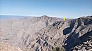 View of Ras Ash, overlooking the Wadi Ghalilah and three of its tributaries: Wadi Litibah, Wadi Barut and Wadi Khabb, from the top of the cliff that forms the eastern slope of Wadi Barut.
 -
 Small mountain village located in the Hajar Mountains (UAE), at an altitude of 1450 m. Very close to the border between UAE and Oman. The village is on the itinerary that follows the well-known mountain trail Stairway to Heaven.


References
[edit]- ^ "Hiking the UAE's Stairway to Heaven: The Ultimate Guide Ras Al Khaimah, UAE Hiking Guide". brokenbootstravel.com. Retrieved 2024-09-09.
- ^ "Trails of the World - Stairways 2 Heaven - Right Bank (Wadi Lithbah to Ras Al Ghash Village) - Muhasin Pallikkal - 2021". wikiloc.com. Retrieved 2024-09-09.
- ^ "Hitting the heights with the Stairway to Heaven in Ras Al Khaimah". The National. Retrieved 2018-09-16.
- ^ "The G.O.A.T. Trail Race is a challenging race which will take place on one of the toughest and most rugged mountains of Ras Al Khaima in the UAE". itra.run. Retrieved 2024-09-09.
- ^ Peakbagger - Jabal Bil Ays
- ^ Mindat.org - Wādī Barut
- ^ FO 371/132894 - 1958 Tribes of Trucial States coast - E F Henderson, Julian F Walker, M S Buckmaster - The National Archives, London, England <https://www.agda.ae/en/catalogue/tna/fo/371/132894/n/38>
- ^ FCO 18/1895 - 1958 - Map - United Arab Emirates (UAE): Ras al-Khaimah - Published by D Survey, Ministry of Defence, United Kingdom - The National Archives, London, England <https://www.agda.ae/en/catalogue/tna/fco/18/1895/n/1>
- ^ GeoNames - Ras al Ghash
- ^ Mindat.org - Ra’s al Waḩḩ
Maps and bibliography
[edit]- William Lancaster; Fidelity Lancaster (2011). Honour Is in Contentment. Life Before Oil in Ras Al-Khaimah (UAE) and Some Neighbouring Regions. ISBN 9783110223392, 3110223392
- Map of Trucial States, Muscat and Oman - Rams - Scale 1:100 000 - Published by D Survey, Ministry of Defence, United Kingdom (1971) - Edition 3-GSGS - The National Archives, London, England
- Heard-Bey, Frauke (2005). From Trucial States to United Arab Emirates : a society in transition. London: Motivate. ISBN 1860631673. OCLC 64689681.
| Cities |  | |
|---|---|---|
| Settlements | ||
| Mountains | ||
Category:United Arab Emirates geography stubs Category:Populated places in the Emirate of Ras Al Khaimah Category:Villages in the United Arab Emirates
External links
[edit]![]() Media related to Ras Ash at Wikimedia Commons
Media related to Ras Ash at Wikimedia Commons