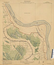
Duckport, Louisiana


Duckport (also Duck Port or Duckport Landing) was a plantation and boat landing in Madison Parish, Louisiana, United States,[2] best known today as one of the endpoints of the unsuccessful Duckport Canal project during the American Civil War. An alternate name for the Duckport Landing was Sparta.[3]
History
[edit]In the 19th century, Duckport Landing was located between Paw Paw Island and Young's Point along the Mississippi River.[1] There was a boat landing at Duckport that was used by mail packet steamboats beginning sometime before 1852.[4] In 1869, the application for a Duck Port post office stated there were about 150 families in the vicinity who would be served by the station.[5]
The sternwheel packet boat Ben Hur burned and sank at Duckport in March 1916.[6] Duckport was flooded in spring 1922.[7] There was an illegal 150-gallon still in operation near Duckport during Prohibition.[8] A fragment of the civil war-era canal was still visible in 1933 from a gravel road that ran from Thomaston to Duckport.[9][10] Thomaston Road had been the "center of wealth" in the area before the war and had been lined with plantation houses.[11] By the 21st century, all that was left of the canal was "a small indentation because area farmers tried to plow it down."[11]
The Duckport Plantation encompassed about 1800 acres as of the 1990s.[12] Duckport Landing no longer exists and has disappeared under the Mississippi River.[13]
See also
[edit]References
[edit]- ^ a b "Historic names and places on the lower Mississippi River / by Marion Bragg". HathiTrust. p. 155. hdl:2027/uc1.$c32669. Retrieved 2024-08-04.
- ^ U.S. Geological Survey Geographic Names Information System: Duckport, Louisiana
- ^ "Mississippi River. Table of distances from Cairo to the passes. Comp. from the surveys of the Mississippi River Commission, 1883". HathiTrust. p. 10. Retrieved 2024-08-04.
- ^ "Vicksburg-area packet boats". The New Orleans Crescent. 1852-09-29. p. 3. Retrieved 2024-08-04.
- ^ U.S. Post Office Department, "Louisiana: La Salle–Morehouse Parishes (Roll 243)", M1126: Post Office Department Reports of Site Locations, 1837–1950, Washington, D.C.: U.S. National Archives and Records Administration, film images 676–683 of 901, NAID 68406066 – via archives.gov
- ^ "Ben Hur (Packet, 1887–1916)". UWDC - UW-Madison Libraries. Retrieved 2024-08-06.
- ^ "The Swollen Mississippi". Slate Magazine. 2011-05-20. Retrieved 2024-08-04.
- ^ "As Time Goes By". The Madison Journal. 1993-01-06. p. 7. Retrieved 2024-08-04.
- ^ "Know Louisiana; a tourist guide to points of general and historic interest. Issued for free distribution in connection with Louisiana highway commission ..." HathiTrust. pp. 27–28. hdl:2027/uiug.30112099802081. Retrieved 2024-08-04.
- ^ "Louisiana place-names of Indian origin no.2". HathiTrust. p. 22. hdl:2027/mdp.39015030547643. Retrieved 2024-08-04.
- ^ a b "Who we are". The News-Star. 2002-06-30. p. 143. Retrieved 2024-08-04.
- ^ "Legals". Tensas Gazette. 1991-09-11. p. 13. Retrieved 2024-08-04.
- ^ "Civil War markers erected". The Madison Journal. 1994-04-27. p. 5. Retrieved 2024-08-04.
