El Carmen de Atrato
El Carmen de Atrato | |
|---|---|
Municipality and town | |
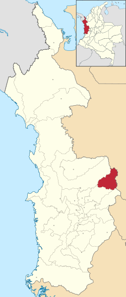
 Location of the municipality and town of El Carmen de Atrato in the Chocó Department of Colombia. | |
| Country | |
| Department | Chocó Department |
| Area | |
| • Total | 931 km2 (359 sq mi) |
| Population (2015) | |
| • Total | 13,819 |
| • Density | 15/km2 (38/sq mi) |
| Time zone | UTC-5 (Colombia Standard Time) |
El Carmen de Atrato is a municipality and town in the Chocó Department, Colombia.
Climate[edit]
El Carmen de Atrato has a subtropical highland climate (Köppen Cfb) which borders a tropical rainforest climate. The town’s high altitude makes its climate far more temperate (similar to that of the Andean Region) than the climate of most of Chocó Department, although it still receives more than twice as much rain as Bogotá.
| Climate data for El Carmen de Atrato town | |||||||||||||
|---|---|---|---|---|---|---|---|---|---|---|---|---|---|
| Month | Jan | Feb | Mar | Apr | May | Jun | Jul | Aug | Sep | Oct | Nov | Dec | Year |
| Mean daily maximum °C (°F) | 23.3 (73.9) |
23.5 (74.3) |
23.8 (74.8) |
23.6 (74.5) |
23.0 (73.4) |
23.2 (73.8) |
23.6 (74.5) |
23.3 (73.9) |
22.8 (73.0) |
22.4 (72.3) |
22.3 (72.1) |
22.5 (72.5) |
23.1 (73.6) |
| Daily mean °C (°F) | 18.2 (64.8) |
18.4 (65.1) |
18.7 (65.7) |
18.6 (65.5) |
18.4 (65.1) |
18.4 (65.1) |
18.5 (65.3) |
18.2 (64.8) |
18.0 (64.4) |
17.7 (63.9) |
17.7 (63.9) |
17.8 (64.0) |
18.2 (64.8) |
| Mean daily minimum °C (°F) | 13.1 (55.6) |
13.3 (55.9) |
13.7 (56.7) |
13.7 (56.7) |
13.8 (56.8) |
13.6 (56.5) |
13.4 (56.1) |
13.2 (55.8) |
13.2 (55.8) |
13.1 (55.6) |
13.2 (55.8) |
13.2 (55.8) |
13.4 (56.1) |
| Average rainfall mm (inches) | 122.3 (4.81) |
127.0 (5.00) |
166.9 (6.57) |
216.9 (8.54) |
279.7 (11.01) |
242.9 (9.56) |
253.6 (9.98) |
216.0 (8.50) |
228.6 (9.00) |
261.8 (10.31) |
255.2 (10.05) |
157.8 (6.21) |
2,528.7 (99.54) |
| Average rainy days (≥ 1 mm) | 11 | 12 | 14 | 18 | 21 | 18 | 17 | 17 | 18 | 20 | 19 | 14 | 199 |
| Source: [2] | |||||||||||||
References[edit]
- ^ "Municipalities of Colombia". statoids. Retrieved 28 April 2020.
- ^ "Data". www.ideam.gov.co. Archived from the original on 2016-08-15. Retrieved 2020-06-26.
External links[edit]
- (in Spanish) El Carmen de Atrato official website
5°53′16″N 75°09′51″W / 5.88778°N 75.1642°W
