
Elisabeth Wolffstraat 2
This article has multiple issues. Please help improve it or discuss these issues on the talk page. (Learn how and when to remove these template messages)
|
| Elisabeth Wolffstraat 2 | |
|---|---|
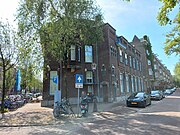
.jpg) Entrance to the school complex (July 2022) | |
 | |
| General information | |
| Type | School |
| Architectural style | Rationalism |
| Location | Amsterdam-West Elisabeth Wolffstraat Tweede Kostverlorenkade |
| Current tenants | Residential apartments, municipal institution |
| Groundbreaking | 1913 |
| Construction started | 1913 |
| Completed | 1915 |
| Opening | February 1915 |
| Owner | Homeowners' association, Municipality |
| Design and construction | |
| Architect(s) | Department of Public Works |
| Designations | Municipal monument |
Elisabeth Wolffstraat 2 and Tweede Kostverlorenkade 5 in Amsterdam-West is a building located at the intersection of Elisabeth Wolffstraat and Tweede Kostverlorenkade, along the Kostverlorenvaart canal.
History
[edit]This area was predominantly agricultural for centuries and, in the late 19th century, became an industrial area belonging to Nieuwer-Amstel. It was the northern tip of the Stads- en Godshuispolder. As Amsterdam needed land for housing its growing population, the city annexed this area. The land was raised and developed around the turn of the 20th century. The street was named on September 21, 1904, after the writer Elisabeth Wolff. The growing population, partly due to large families, created a demand for schools. Construction began around 1914 on the "Second Public Work and Learning School" with a caretaker's residence and garden on a plot between the street and canal. The "First Public Work and Learning School," intended for the training of domestic workers, was located at Lepelstraat 17 in the east of the city. As the number of applicants grew in the early 20th century, a second school became necessary. In 1912, the municipality decided to establish a similar school on the west side of the city. The foundation was tendered on May 19, 1913, and the superstructure on November 10. The school opened on February 1, 1915, initially accommodating the overflow from the Lepelstraat school. The 1915/1916 school year was its first full academic year. In the 1920s, the school's curriculum expanded as a vocational school.
Building
[edit]The school faced the street, while the caretaker's residences were adjacent to the canal, near a gypsum factory. The building was designed by the Department of Public Works in the rationalist style, featuring three stories. It housed around 180 students in classrooms, kitchens, ironing rooms, and domestic science rooms. For nearly a century after its completion, the building continued to function as an educational institution, including being part of the "Christian Secondary School for Vocational Education J.J. Buskes" in the 1980s.
The gypsum factory, which predated the urban development (Lange Bleekerspad 72–74), was demolished in 1929. In 1931, housing was built adjacent to the school complex, designed by Th.J. Lammers.
In April 2009, the building was designated as a Municipal monument in the Netherlands. It is, along with a corner building at Van Alphenstraat 6, one of the few municipal or national monuments on the street.
Due to demographic changes, the school became unnecessary in the 2010s. The building was converted into an apartment complex and a municipal office for assisting people with psychiatric or addiction issues.
The year "Anno 1914" is inscribed on one of the portico closures.
Gallery
[edit]-
 Building viewed from Tweede Kostverlorenkade 5 (July 2022)
 -
 Building viewed from Elisabeth Wolffstraat 2 (July 2022)
 -
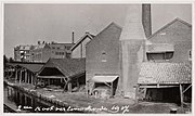 Gypsum factory with the school behind (circa 1917)
.jpg)
.jpg)

References
External links
[edit]- Amsterdam op de kaart/Monumenten Inventarisatie project (accessed 28 November 2022)
- Editorial (1912-10-11). "Stadsnieuws Gemeenteraad". Algemeen Handelsblad. Retrieved 2022-11-22 – via delpher.nl.
- Editorial (1915-03-16). "inschrijving Werk- en Leerschool". De Telegraaf. Retrieved 2022-11-22 – via delpher.nl.
- "Het maken van de onderbouw van de 2e werk- en leerschool (dossier 22100)". Centraal Tekeningen Archief. 1913. Archived from the original on 2022-11-28. Retrieved 2022-11-28 – via Stadsarchief Amsterdam.
- "Het maken van de bovenbouw van de 2e werk- en leerschool (dossier 22369)". Centraal Tekeningen Archief. 1913. Archived from the original on 2022-11-28. Retrieved 2022-11-28 – via Stadsarchief Amsterdam.