Ese Odo
Appearance
Ese Odo | |
|---|---|
| Coordinates: 6°13′03″N 4°57′52″E / 6.2174°N 4.9645°E | |
| Country | |
| State | Ondo State |
| Time zone | UTC+1 (WAT) |
 | |
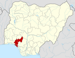
Ese Odo is a Local Government Area in Ondo State, Nigeria, populated by the Ijaw (Izon) ethnic sub groups of the Western Apoi tribe and the Arogbo tribe.[1] Its headquarters are in the town of Igbekebo and its one of the LGA with crude oil in Ondo State. The biggest towns within this Local Government Area are Kiribo, Arogbo, Igbobini, Igbotu,and Igbekebo.
It has an area of 762 km2 and a population of 154,978 at the 2006 census and its one of the oil producing LGA in the State.[citation needed]
The postal code of the area is 352.[2]
References
[edit]- ^ "Communities In Ese Odo Area Of Ondo State Submerged In Natural Disaster". Sahara Reporters. 21 July 2014. Retrieved 8 April 2022.
- ^ "Post Offices- with map of LGA". NIPOST. Archived from the original on 7 October 2009. Retrieved 20 October 2009.
2. https://nigeriazipcodes.com/5965/list-of-towns-and-villages-in-ese-odo-lga/. Retrieved 2019-12-16.


