
Federal Territory Mosque
| Federal Territory Mosque | |
|---|---|
Masjid Wilayah Persekutuan | |
  | |
| Religion | |
| Affiliation | Sunni Islam |
| Ecclesiastical or organizational status | Mosque |
| Status | Active |
| Location | |
| Location | Jalan Duta, Segambut, Kuala Lumpur |
| Country | Malaysia |
 Location of the mosque in Kuala Lumpur | |
| Geographic coordinates | 3°10′19″N 101°40′16″E / 3.17194°N 101.67111°E |
| Architecture | |
| Type | Mosque architecture |
| Style | |
| Groundbreaking | 1998 |
| Completed | 2000 |
| Specifications | |
| Capacity | 17,000 worshippers |
| Dome(s) | 22 |
| Minaret(s) | Two |
| Site area | 5 ha (12 acres) |
| Materials | Glass fibre |
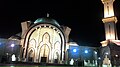
The Federal Territory Mosque (Malay: Masjid Wilayah Persekutuan) is a Sunni mosque, located in Kuala Lumpur, Malaysia. The mosque is situated near MATRADE complex and the Federal Government Complex off Jalan Duta, in the Segambut district.[1]
History
[edit]The Kuala Lumpur Mosque was constructed between 1998 and 2000. It is situated on a 5-hectare (12-acre) site near the Government Office Complex along Jalan Duta. The Wilayah Persekutuan (Federal Territory) Mosque was opened to the public on 25 October 2000 and was officiated by the 12th Yang di-Pertuan Agong, Tuanku Syed Sirajuddin ibni Almarhum Syed Putra Jamalulail. It is the 44th mosque built by the Government within the city limits. The mosque can accommodate 17,000 worshippers at any one time.
Architecture
[edit]The mosque's design is a blend of Ottoman and Malay architectural styles, heavily influenced by the Blue Mosque in Istanbul, Turkey. It has 22 domes made from a composite material of glass fibre fabric mixed with epoxy resin to make it durable and light.
Gallery
[edit]-
 Mosque in dawn
 -
 Dome of the mosque
 -
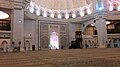 Interior of mosque
 -
 Minaret of mosque


See also
[edit]References
[edit]- ^ "Sejarah Masjid". Masjid Wilayah Persekutuan. Archived from the original on 24 March 2020.
External links
[edit]![]() Media related to Federal Territory Mosque at Wikimedia Commons
Media related to Federal Territory Mosque at Wikimedia Commons
This article about a mosque or other Islamic place of worship in Malaysia is a stub. You can help Wikipedia by expanding it. |