
File:1776 map of coastal Georgia.tif

Size of this JPG preview of this TIF file: 755 × 600 pixels. Other resolutions: 302 × 240 pixels | 604 × 480 pixels | 988 × 785 pixels.
Original file (988 × 785 pixels, file size: 1.59 MB, MIME type: image/tiff)
| This is a file from the Wikimedia Commons. Information from its description page there is shown below. Commons is a freely licensed media file repository. You can help. |
Summary
| Description |
English: Crop of map with the following description:
Scale ca. 1:3,000,000. Relief shown pictorially. "The seat of war, in the southern British colonies, comprehending North and South Carolina, Georgia, East and West Florida, &ca." Hand colored. Insets: Plan of Charlestown [ca. 1:24,000]--Plan of St. Augustine [ca. 1:15,840] LC Maps of North America, 1750-1789, 1396 Available also through the Library of Congress Web site as a raster image. Vault AACR2 |
| Date | |
| Source | https://www.loc.gov/item/gm71005467/ |
| Author | Romans, Bernard; De Brahm, John Gerar William; Robert Sayer And John Bennett (Firm) |
Licensing
|
This is a faithful photographic reproduction of a two-dimensional, public domain work of art. The work of art itself is in the public domain for the following reason:
The official position taken by the Wikimedia Foundation is that "faithful reproductions of two-dimensional public domain works of art are public domain".
This photographic reproduction is therefore also considered to be in the public domain in the United States. In other jurisdictions, re-use of this content may be restricted; see Reuse of PD-Art photographs for details. | ||||

|
This map is available from the United States Library of Congress's Geography & Map Division
under the digital ID g3870.ar139600. This tag does not indicate the copyright status of the attached work. A normal copyright tag is still required. See Commons:Licensing.
|
File history
Click on a date/time to view the file as it appeared at that time.
| Date/Time | Thumbnail | Dimensions | User | Comment | |
|---|---|---|---|---|---|
| current | 20:45, 7 April 2022 | 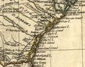 | 988 × 785 (1.59 MB) | JJonahJackalope | Uploaded a work by Romans, Bernard; De Brahm, John Gerar William; Robert Sayer And John Bennett (Firm) from https://www.loc.gov/item/gm71005467/ with UploadWizard |
File usage
The following pages on the English Wikipedia use this file (pages on other projects are not listed):
Global file usage
The following other wikis use this file:
- Usage on ru.wikipedia.org