
File:AERIAL VIEW, LOOKING WEST, SHOWING RADAR SITE IN UPPER LEFT, BARRACKS IN MIDDLE, AND LAUNCH AREA IN LOWER PORTION OF PHOTO Everett Weinreb, photographer, April 1988 - Los HAER CAL,19-SYLM.V,1-2.tif

Size of this JPG preview of this TIF file: 751 × 600 pixels. Other resolutions: 301 × 240 pixels | 601 × 480 pixels | 962 × 768 pixels | 1,280 × 1,022 pixels | 2,560 × 2,044 pixels | 5,057 × 4,038 pixels.
Original file (5,057 × 4,038 pixels, file size: 19.48 MB, MIME type: image/tiff)
| This is a file from the Wikimedia Commons. Information from its description page there is shown below. Commons is a freely licensed media file repository. You can help. |
Summary
| Photographer |
Related names:
|
|||
| Title |
AERIAL VIEW, LOOKING WEST, SHOWING RADAR SITE IN UPPER LEFT, BARRACKS IN MIDDLE, AND LAUNCH AREA IN LOWER PORTION OF PHOTO Everett Weinreb, photographer, April 1988 - Los Pinetos Nike Missile Site, Santa Clara Road, Los Angeles National Forest, Sylmar, Los Angeles County, CA |
|||
| Depicted place | California; Los Angeles County; Sylmar | |||
| Date | Documentation compiled after 1968 | |||
| Dimensions | 4 x 5 in. | |||
| Current location |
Library of Congress Prints and Photographs Division Washington, D.C. 20540 USA http://hdl.loc.gov/loc.pnp/pp.print |
|||
| Accession number |
HAER CAL,19-SYLM.V,1-2 |
|||
| Credit line |
|
|||
| Notes |
|
|||
| Source | https://www.loc.gov/pictures/item/ca1499.photos.012867p | |||
| Permission (Reusing this file) |
|

| Object location | | View this and other nearby images on: OpenStreetMap |
|---|
File history
Click on a date/time to view the file as it appeared at that time.
| Date/Time | Thumbnail | Dimensions | User | Comment | |
|---|---|---|---|---|---|
| current | 12:29, 3 July 2014 | 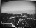 | 5,057 × 4,038 (19.48 MB) | Fæ | GWToolset: Creating mediafile for Fæ. HABS batch upload 2 July 2014 (301:400) |
File usage
The following pages on the English Wikipedia use this file (pages on other projects are not listed):