
File:CONSTRUCTION DETAIL WEST PORTAL SOUTHWEST CORNER. NOTE AIR RAID SHELTER SIGN. - Wawona Tunnel, Wawona Road through Turtleback Dome, Yosemite Village, Mariposa County, CA HAER CAL,22-YOSEM,26-2.tif

Size of this JPG preview of this TIF file: 488 × 599 pixels. Other resolutions: 195 × 240 pixels | 391 × 480 pixels | 626 × 768 pixels | 834 × 1,024 pixels | 1,669 × 2,048 pixels | 4,074 × 5,000 pixels.
Original file (4,074 × 5,000 pixels, file size: 19.43 MB, MIME type: image/tiff)
| This is a file from the Wikimedia Commons. Information from its description page there is shown below. Commons is a freely licensed media file repository. You can help. |
Summary
| CONSTRUCTION DETAIL WEST PORTAL SOUTHWEST CORNER. NOTE AIR RAID SHELTER SIGN. - Wawona Tunnel, Wawona Road through Turtleback Dome, Yosemite Village, Mariposa County, CA | ||||
|---|---|---|---|---|
| Photographer |
Grogan, Brian C. Related names:
|
|||
| Title |
CONSTRUCTION DETAIL WEST PORTAL SOUTHWEST CORNER. NOTE AIR RAID SHELTER SIGN. - Wawona Tunnel, Wawona Road through Turtleback Dome, Yosemite Village, Mariposa County, CA |
|||
| Depicted place | California; Mariposa County; Yosemite Village | |||
| Date | 1991 | |||
| Dimensions | 4 x 5 in. | |||
| Current location |
Library of Congress Prints and Photographs Division Washington, D.C. 20540 USA http://hdl.loc.gov/loc.pnp/pp.print |
|||
| Accession number |
HAER CAL,22-YOSEM,26-2 |
|||
| Credit line |
|
|||
| Notes |
|
|||
| Source | https://www.loc.gov/pictures/item/ca1652.photos.041857p | |||
| Permission (Reusing this file) |
|
|||

| Object location | | View this and other nearby images on: OpenStreetMap |
|---|
File history
Click on a date/time to view the file as it appeared at that time.
| Date/Time | Thumbnail | Dimensions | User | Comment | |
|---|---|---|---|---|---|
| current | 05:02, 4 July 2014 | 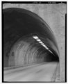 | 4,074 × 5,000 (19.43 MB) | Fæ | GWToolset: Creating mediafile for Fæ. HABS batch upload 2 July 2014 (301:400) |
File usage
The following pages on the English Wikipedia use this file (pages on other projects are not listed):