
File:Clarence Strait, Australia ESA19709551.tiff

Original file (19,808 × 10,980 pixels, file size: 622.27 MB, MIME type: image/tiff)
| This is a file from the Wikimedia Commons. Information from its description page there is shown below. Commons is a freely licensed media file repository. You can help. |
Summary
| Warning | The original file is very high-resolution. It might not load properly or could cause your browser to freeze when opened at full size. |
|---|
| Description |
English: The Copernicus Sentinel-2 mission takes us over Clarence Strait, a narrow body of water in Australia’s Northern Territory. The strait ties the Beagle Gulf in the west with the Van Diemen Gulf to the east and separates Australia’s mainland from Melville Island, part of the Tiwi Islands. The southernmost tip of Melville is visible in the upper part of the image. The three islands in the southern part of the strait, are the Vernon Islands, which host navigation aids to assist vessels passing through the strait. Australia’s Northern Territory is a sparsely-populated region. With a population of around 140 000, Darwin is the territory’s capital and largest city, and is visible in grey in the centre of the image. In 1839, the HMS Beagle sailed into the waters of what is now known as Darwin Harbour. The harbour was named after the British evolutionist Charles Darwin, but, contrary to popular belief, Darwin himself never visited the area. With a strong Aboriginal culture, art and tropical summers, Darwin is a popular tourist destination. The Crocosaurus Cove in the heart of the city houses the world’s largest display of Australian reptiles. The waters that surround Darwin are riddled with saltwater crocodiles and deadly box jellyfish, which inhabit the waters from October to May. The Adelaide River, known for its high concentration of saltwater crocodiles, can be seen to the right of Darwin, snaking its way northwards, flowing 180 km before emptying into the Timor Sea. The Djukbinj National Park, visible east of Adelaide River, is a protected area and consists mostly of wetlands. The close vicinity to the water makes the park a major breeding ground for a variety of water birds, including magpie geese, herons and egrets. Copernicus Sentinel-2 is a two-satellite mission. Each satellite carries a high-resolution camera that images Earth’s surface in 13 spectral bands. Data from Copernicus Sentinel-2 can help monitor changes in land cover. This image, captured on 24 June 2019, is also featured on the Earth from Space video programme. |
| Date | Taken on 24 June 2019 |
| Source | Clarence Strait, Australia |
| Author | European Space Agency |
| Other versions |
|
| Activity | Observing the Earth |
| Mission | Sentinel-2 |
| Set | Earth observation image of the week |
| System | Copernicus |
.jpg)
Licensing

|
This image contains data from a satellite in the Copernicus Programme, such as Sentinel-1, Sentinel-2 or Sentinel-3. Attribution is required when using this image.
Attribution: Contains modified Copernicus Sentinel data 2019
The use of Copernicus Sentinel Data is regulated under EU law (Commission Delegated Regulation (EU) No 1159/2013 and Regulation (EU) No 377/2014). Relevant excerpts:
Free access shall be given to GMES dedicated data [...] made available through GMES dissemination platforms [...].
Access to GMES dedicated data [...] shall be given for the purpose of the following use in so far as it is lawful:
GMES dedicated data [...] may be used worldwide without limitations in time.
GMES dedicated data and GMES service information are provided to users without any express or implied warranty, including as regards quality and suitability for any purpose. |
This media was created by the European Space Agency (ESA).
Where expressly so stated, images or videos are covered by the Creative Commons Attribution-ShareAlike 3.0 IGO (CC BY-SA 3.0 IGO) licence, ESA being an Intergovernmental Organisation (IGO), as defined by the CC BY-SA 3.0 IGO licence. The user is allowed under the terms and conditions of the CC BY-SA 3.0 IGO license to Reproduce, Distribute and Publicly Perform the ESA images and videos released under CC BY-SA 3.0 IGO licence and the Adaptations thereof, without further explicit permission being necessary, for as long as the user complies with the conditions and restrictions set forth in the CC BY-SA 3.0 IGO licence, these including that:
See the ESA Creative Commons copyright notice for complete information, and this article for additional details.
|
 | |
This file is licensed under the Creative Commons Attribution-ShareAlike 3.0 IGO license. Attribution: ESA, CC BY-SA IGO 3.0
| ||
File history
Click on a date/time to view the file as it appeared at that time.
| Date/Time | Thumbnail | Dimensions | User | Comment | |
|---|---|---|---|---|---|
| current | 13:12, 7 June 2020 | 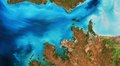 | 19,808 × 10,980 (622.27 MB) | OptimusPrimeBot | #Spacemedia - Upload of https://esamultimedia.esa.int/img/2019/09/Darwin_Sentinel-2A_MSIL1C_24June2019_432_MM.tif via Commons:Spacemedia |
File usage
Global file usage
The following other wikis use this file:
- Usage on ceb.wikipedia.org
- Usage on es.wikipedia.org
- Usage on www.wikidata.org