
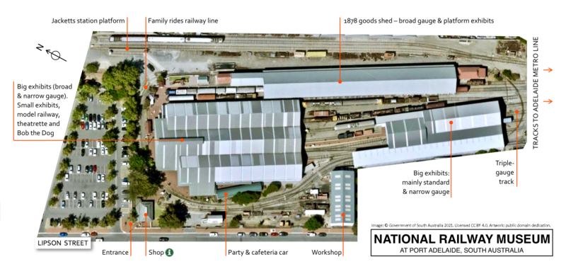
File:Map of National Railway Museum premises, South Australia, in 2021.tif
Size of this PNG preview of this TIF file: 800 × 380 pixels. Other resolutions: 320 × 152 pixels | 640 × 304 pixels | 1,024 × 486 pixels | 1,280 × 607 pixels | 2,202 × 1,045 pixels.
Original file (2,202 × 1,045 pixels, file size: 8.78 MB, MIME type: image/tiff)
| This is a file from the Wikimedia Commons. Information from its description page there is shown below. Commons is a freely licensed media file repository. You can help. |
Summary
| Description |
English: Map of National Railway Museum premises, Port Adelaide, South Australia, in 2021 |
| Date | |
| Source | Background image: Location SA Map Viewer (https://data.sa.gov.au/data/showcase/location-sa-map-viewer) |
| Author |
Background image: Government of South Australia (CC BY 4.0) Artwork: SCHolar44 |
| Camera location | | View this and other nearby images on: OpenStreetMap |
|---|
Licensing
This file is licensed under the Creative Commons Attribution 4.0 International license.
Attribution: Government of South Australia
The Government of South Australia owns copyright in this work. Its copyright statement includes: "With the exception of the Piping Shrike emblem, images, and other material or devices protected by a trademark and subject to review by the Government of South Australia at all times, the content of this website is licensed under the Creative Commons Attribution 4.0 licence."
The Government of South Australia owns copyright in this work. Its copyright statement includes: "With the exception of the Piping Shrike emblem, images, and other material or devices protected by a trademark and subject to review by the Government of South Australia at all times, the content of this website is licensed under the Creative Commons Attribution 4.0 licence."
- You are free:
- to share – to copy, distribute and transmit the work
- to remix – to adapt the work
- Under the following conditions:
- attribution – You must give appropriate credit, provide a link to the license, and indicate if changes were made. You may do so in any reasonable manner, but not in any way that suggests the licensor endorses you or your use.
File history
Click on a date/time to view the file as it appeared at that time.
| Date/Time | Thumbnail | Dimensions | User | Comment | |
|---|---|---|---|---|---|
| current | 03:41, 20 February 2022 |  | 2,202 × 1,045 (8.78 MB) | SCHolar44 | Uploaded a work by Background image: Government of South Australia (CC BY 4.0) Artwork: SCHolar44 from Background image: Location SA Map Viewer (https://data.sa.gov.au/data/showcase/location-sa-map-viewer) with UploadWizard |
File usage
The following pages on the English Wikipedia use this file (pages on other projects are not listed):