
File:OBLIQUE ELEVATION, LOOKING NORTHEAST. - Grant Road Bridge, Spanning Raquette River at Grant Road, Raymondville, St. Lawrence County, NY HAER NY,45-RAYM,2-2.tif

Size of this JPG preview of this TIF file: 800 × 565 pixels. Other resolutions: 320 × 226 pixels | 640 × 452 pixels | 1,024 × 723 pixels | 1,280 × 904 pixels | 2,560 × 1,808 pixels | 5,000 × 3,531 pixels.
Original file (5,000 × 3,531 pixels, file size: 16.84 MB, MIME type: image/tiff)
| This is a file from the Wikimedia Commons. Information from its description page there is shown below. Commons is a freely licensed media file repository. You can help. |
Summary
| OBLIQUE ELEVATION, LOOKING NORTHEAST. - Grant Road Bridge, Spanning Raquette River at Grant Road, Raymondville, St. Lawrence County, NY | ||||
|---|---|---|---|---|
| Title |
OBLIQUE ELEVATION, LOOKING NORTHEAST. - Grant Road Bridge, Spanning Raquette River at Grant Road, Raymondville, St. Lawrence County, NY |
|||
| Depicted place | New York; St. Lawrence County; Raymondville | |||
| Dimensions | 5 x 7 in. | |||
| Current location |
Library of Congress Prints and Photographs Division Washington, D.C. 20540 USA http://hdl.loc.gov/loc.pnp/pp.print |
|||
| Accession number |
HAER NY,45-RAYM,2-2 |
|||
| Credit line |
|
|||
| Source | https://www.loc.gov/pictures/item/ny1776.photos.351179p | |||
| Permission (Reusing this file) |
|
|||

|
This is an image of a place or building that is listed on the National Register of Historic Places in the United States of America. Its reference number is 84002961. |
File history
Click on a date/time to view the file as it appeared at that time.
| Date/Time | Thumbnail | Dimensions | User | Comment | |
|---|---|---|---|---|---|
| current | 08:58, 1 August 2014 | 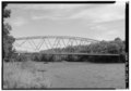 | 5,000 × 3,531 (16.84 MB) | Fæ | GWToolset: Creating mediafile for Fæ. HABS 31 July 2014 (2301:2600) |
File usage
The following pages on the English Wikipedia use this file (pages on other projects are not listed):
Global file usage
The following other wikis use this file:
- Usage on www.wikidata.org