
File talk:Rif Aleppo2.svg
Thank you[edit]
Thank you for the new map. This larger map makes more sense as to how things progressed. [March 8, 2014]
Legend additions[edit]
Very nice map!
The legend could be augmented to explain what the "triangles" signify. Are they checkpoints? Also, it would help if there was horizontal bar, perhaps in the lower left area, indicating scale in kilometers. Hulahoop122 (talk) 23:52, 8 March 2014 (UTC)
- From what I gather, the brown triangles are local peak points/heights. It's actually kind of useful since local heights are frequently the points of contention between the regime and opposition. Kami888 (talk) 00:38, 9 March 2014 (UTC)
What does the gray area mean? No control, Islamist control or something else? --109.60.127.225 (talk) 13:36, 12 March 2014 (UTC)
- The grey/black area means ISIS control. Just like on the Template:Syrian civil war detailed map. Esn (talk) 03:58, 16 March 2014 (UTC)
Ramousah, Jdeydeh and Ashrafiyeh[edit]
Per a new pro-opposition map [1] Ramousah and Jdeydeh districts are firmly in government hands, please change them to red. Also, here is one more map [2], based on opposition sources, per which Ramousah and Jdeydeh are government-held, as well as Ashrafiyeh. So please change Ashrafiyeh to red too please. EkoGraf (talk) 10:59, 24 March 2014 (UTC)
- I am not sure about Jdeydeh because I don't know the precise borders of the district and both maps show rebel presence around that area. Only one of the maps confirms Ashrafiyeh and that one is just a very bad source all around for our purposes (clearly very abstract and inaccurate), the other shows it as mostly YPG. Both however appear to confirm that the ring road and everything south of it is under government control, so I'll make the change based on that. Kami888 (talk) 14:22, 24 March 2014 (UTC)
- They also both show the majority of Salah-ad-din and Saif al-Doula as government held. I am not sure if the map should be changed to reflect that. Kami888 (talk) 14:37, 24 March 2014 (UTC)
Jdeydeh has changed on https://en.wikipedia.org/wiki/File:Battle_of_Aleppo_map.svg please update the map as well. Also most part of Salaheddine. Furthermore al-Aziza and al-Maamel went red Paolowalter (talk) 22:54, 26 March 2014 (UTC)
Sheikh Najjar[edit]
Sheikh Najjar half red per maps posted by sources close to both sides of the conflict Pro-Government Pro-rebel The region of sheykh Najjar should be marked ad conflict area: http://www.almanar.com.lb/english/adetails.php?fromval=1&cid=23&frid=23&eid=144098 MZarif (talk) 14:38, 4 April 2014 (UTC)
Aleppo Map[edit]
The aleppo map should be edited in my opinion according to this sources. http://pydrojava.net/eng/index.php/news/157-liwaa-jabhat-al-akrad-liberated-3-regions-in-aleppo
And this videos are proof that Jabhat al akrad are present even in Hayderiye http://www.youtube.com/watch?v=HQLyKW-KVSQ
Also i wonder is it still clashes going on in Eshrefiyeh or do we simply not know if YPG succeded to defend it or if SAA captured it? — Preceding unsigned comment added by KurdishFalcon (talk • contribs) 22:03, 26 March 2014 (UTC)
Why this map doesn't change ,a lots of changes happened!!!MZarif (talk) 04:07, 7 April 2014 (UTC)
New AC map[edit]
The map should be updated marking government controlled the areas marked as such by the new AC map: https://twitter.com/CdricLabrousse/status/454351857402396672/photo/1 --Paolowalter (talk) 08:06, 11 April 2014 (UTC)
- I am not really seeing any gains by SAA relative to the current map, this map just has larger areas marked as contested due to frequently shifting frontlines and disagreements between pro-government and anti-government mappers. For example, it's probably better to keep the entire Sheikh Najjar district as contested for now rather than trying to draw a more precise frontline, because there is no consensus on where exactly that frontline is within the district, and it is still subject to frequent change. Let's try to draw precise frontlines only when we actually know with decent certainty where they are exactly, and when they're not changing on almost daily basis. Kami888 (talk)
- In general terms I agree with you. Nevertheless it is a phylosophy different from what is used in the main page of http://en.wikipedia.org/wiki/Template:Syrian_civil_war_detailed_map. Fro this particular case, you can see a large stretch of government controlled area reacing Khan al-Asal and that is a major shift. Also the northern part of Bustan al.Qasr are clearly controlled by the government. Otherwise if you are too conservative, you risk of having an obsolete map, like the one of Battle of Aleppo.79.41.102.144 (talk) 19:48, 12 April 2014 (UTC)
- Well you bring up interesting points, but I still think being conservative is better than rushing and having edit wars over minor advances. If you feel strongly the other way, I'm not stopping you from editing the map yourself, you know. :) As for the "large stretch of government controlled area reacing Khan al-Asal" and "the northern part of Bustan al.Qasr", here's a pro-government map that actually shows those areas as rebel held. So go figure, eh? 98.231.43.200 (talk) 18:55, 13 April 2014 (UTC)
- In general terms I agree with you. Nevertheless it is a phylosophy different from what is used in the main page of http://en.wikipedia.org/wiki/Template:Syrian_civil_war_detailed_map. Fro this particular case, you can see a large stretch of government controlled area reacing Khan al-Asal and that is a major shift. Also the northern part of Bustan al.Qasr are clearly controlled by the government. Otherwise if you are too conservative, you risk of having an obsolete map, like the one of Battle of Aleppo.79.41.102.144 (talk) 19:48, 12 April 2014 (UTC)
https://www.facebook.com/syriahroe/posts/512581522183524?stream_ref=10 indicates that the SAA is present in A’ndan. This town should be contested in some way.Paolowalter (talk) 16:58, 11 April 2014 (UTC)
This map is fine until a major shift occurs, or a sustainable advance. Every time someone 'launches an attack' is not enough to just shift fronts. Thanks admin — Preceding unsigned comment added by 76.127.127.203 (talk) 08:44, 12 April 2014 (UTC)
Rebel Offensive[edit]
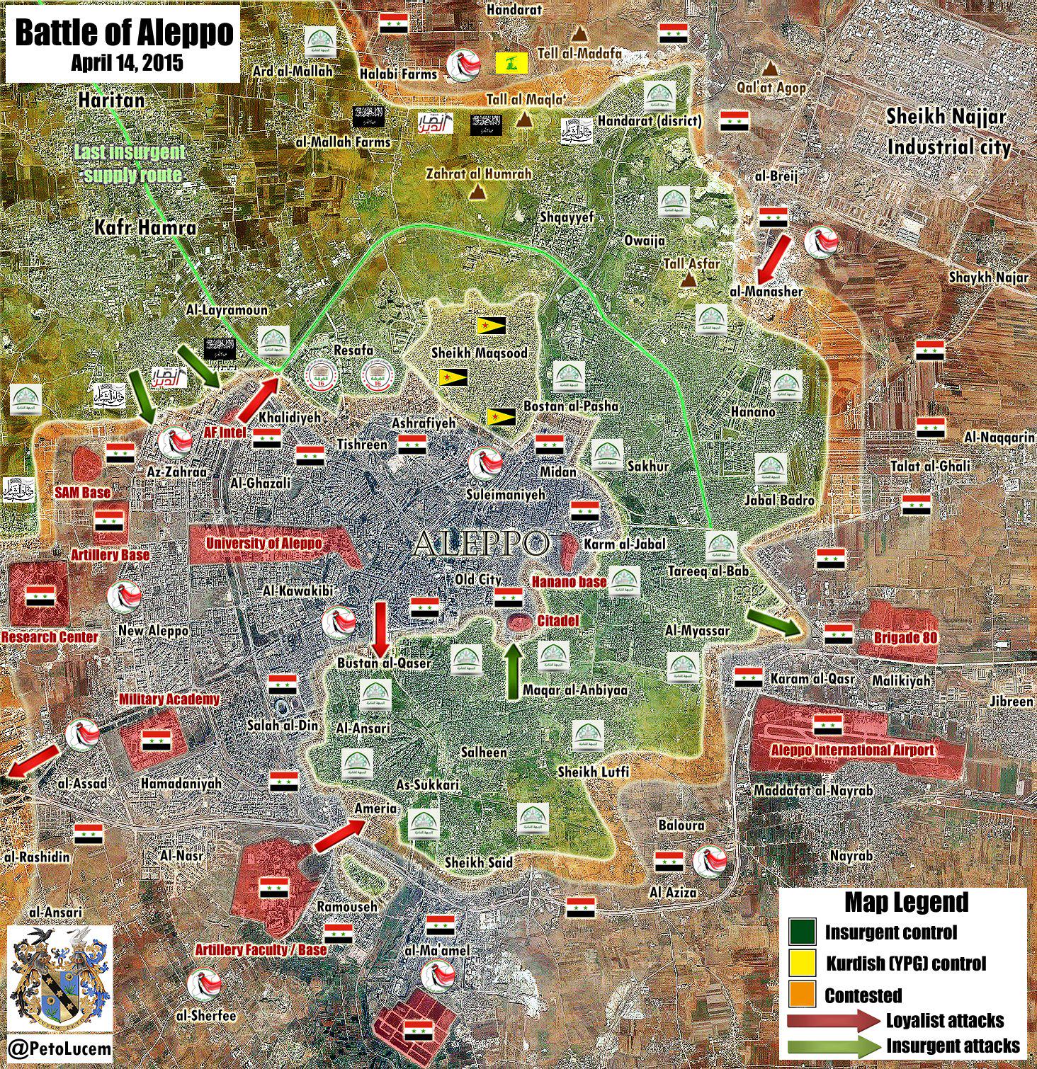
Ramouseh & Rashidin parts need an update. Layramoon must be green. Sheikh Najjar Industrial city regime offensive is stopped. — Preceding unsigned comment added by 93.155.104.15 (talk) 06:16, 14 April 2014 (UTC)
There are a lot videos with rebels in the north part of Ramouseh, a few with easy geolocalization. Yes, I know that this is not a source for wikipedia but complement the previous news.
https://www.youtube.com/channel/UCjPVu55t-To3TEyNEskVi9Q/videos
And a article in EAworldwiev .
http://eaworldview.com/2014/04/syria-daily-regime-trouble-aleppo/ — Preceding unsigned comment added by 81.35.118.73 (talk) 13:31, 14 April 2014 (UTC)
Aziza[edit]
I agree that we cannot change the map just like that for any advance. But I think we should make a list of the changes that must be done eventually. Here is an article from SOHR http://www.syriahr.com/index.php?option=com_news&nid=18129&Itemid=2&task=displaynews#.U1Kf9Pl_sYk saying that rebels are on the borders of Aziza, unlike what the map says.Oussj (talk) 16:15, 19 April 2014 (UTC)
Map is obsolete[edit]
Here is a news and an updated map, which is really significiantly different from current map
http://nationalinterest.org/blog/the-buzz/aleppo-syrias-stalingrad-10320 — Preceding unsigned comment added by 88.253.209.56 (talk) 18:27, 23 April 2014 (UTC)
- It's interesting, but there's little reason to believe that this MS paint map is more accurate than the map we have. Kami888 (talk) 19:29, 26 April 2014 (UTC)
WSJ map[edit]
http://online.wsj.com/news/interactive/ALEPPO0425?ref=SB10001424052702304626304579505351626614392 Boredwhytekid (talk) 19:58, 25 April 2014 (UTC)
Army take news zones in east[edit]
Al Matahen and Sheikh Najjar
https://www.youtube.com/watch?v=F1-3G_tb7ZA
http://www.liveleak.com/view?i=804_1398544119 — Preceding unsigned comment added by LogFTW (talk • contribs) 00:34, 27 April 2014 (UTC)
Shammar[edit]
Per SOHR [3] the Army captured the village of Shammar, east of Aleppo [4]. So you need to appropriately push government-held territory (red) a bit to the east to encompase the village. EkoGraf (talk) 03:08, 27 April 2014 (UTC)
- For the record, FARS claims that also the next town Suran has been taken by SAAR
[5]. Just let watch carefully, if these news surface elsewhere. Paolowalter (talk) 06:18, 30 April 2014 (UTC)
Toward al-Bab[edit]
Advance of SAA east of Aleppo toward al-Bab [6]. Furthermore Suran, reported occupied by SAA by Fars, is in the middle. The problem is this map is not updated.Paolowalter (talk) 16:52, 30 April 2014 (UTC)
Syrian troops seized the town Al Madyunah and Soran after ISIS withdraw from the town without clashes.Hawar News Hanibal911 (talk) 17:46, 1 May 2014 (UTC)
Actually wrong Soran, its this one [7]. But to summ it up. Map is becoming out-of-dated. Government-held territory needs to be extended east to include Shammar, Al Madyunah and Soran. EkoGraf (talk) 18:47, 1 May 2014 (UTC)
Syrian Army advanced on east Aleppo[edit]
Syrian Army Taken total or partiality Al Matahen zone, Shaykh Najjarn and al-Ramouseh in east of Aleppo the days May 25, 26, 27 and 28
http://www.liveleak.com/view?i=627_1398785300
http://www.liveleak.com/view?i=986_1398646885
http://www.liveleak.com/view?i=993_1398733982
http://www.liveleak.com/view?i=474_1398660859
http://www.liveleak.com/view?i=804_1398544119 — Preceding unsigned comment added by LogFTW (talk • contribs) 09:28, 1 May 2014 (UTC)
Clashes continue between Regime Forces and Armed Opposition Groups in Dowar Alborj in Allyramon area in north Aleppo and Regime Forces progress in the region.Hawar News Hanibal911 (talk) 17:48, 1 May 2014 (UTC)
Arab Chronicle map[edit]
Look at the AC map [8]. The government controlled areas should cover at least those indicated in the map. If it is not maintained this map is useless. Paolowalter (talk) 19:05, 1 May 2014 (UTC)
Recent changes[edit]
- Arqoub was already shown as government held, there was a rebel incursion since the last update. I'm also not entirely sure where Bani Zaid is though. I just made northern Rasafa region green for now but the matter should be settled on the "Battle of Aleppo" talk page, I'll copy whatever decision is made there. Kami888 (talk) 04:12, 3 May 2014 (UTC)
Bani Zaid according to wikimapia is visible [9], the northern part of the area on the west of Sheick Maqsood. In the Battle of Aleppo it is apparently used as a synonim of Rasafeh, that is apparently larger. Rebel control is sure on the northern part, not clear the situation in the southern part. Paolowalter (talk) 19:38, 3 May 2014 (UTC)
Sheick Najar[edit]
SAA advance farther in Sheick Najar. See [10]. This map is lagging far behind the development. Paolowalter (talk) 19:46, 3 May 2014 (UTC)
So the whole south-west corner of the industrial zone needs to go red. EkoGraf (talk) 21:04, 3 May 2014 (UTC)
- The very south-west portion is already red, look closely. As for the rest, I prefer to keep it as contested until we get more concrete information. Kami888 (talk) 21:06, 3 May 2014 (UTC)
- The area up to and including Bureij roundabout (at the midpoint between the northern and southern borders of Sheikh Najjar) is confirmed under regime control, by multiple sources and by photo evidence https://twitter.com/2Rook14/status/462689529652985856/photo/1 99.246.110.7 (talk) 22:17, 3 May 2014 (UTC)
More sources[edit]
SANA said a "Aleppo Hill" was taken by the army http://sana.sy/eng/337/2014/05/03/542302.htm
These are recent sources from the currently situations yes Is from Iran but they are very active following the situation
http://english.farsnews.com/newstext.aspx?nn=13930210001441
http://english.farsnews.com/newstext.aspx?nn=13930213000996
http://english.farsnews.com/newstext.aspx?nn=13930209001409
http://www.tasnimnews.com/English/Home/Single/356860
Recent TV Reports
https://www.youtube.com/watch?v=aV78tMqct1I
https://www.youtube.com/watch?v=ZVIPwEDSoMs
Ill hope it helps you — Preceding unsigned comment added by LogFTW (talk • contribs) 09:02, 4 May 2014 (UTC)
- This the map from the pro opposition source displays the army advances in the north of Aleppo and shows that the army captured the territory east of Sheik Najar industrial zone as well as army moving towards Aleppo prison. Hanibal911 (talk) 09:22, 4 May 2014 (UTC)
Army offensive in Aleppo[edit]
Army launched a major offensive in Aleppo. The Syrian army broke siege of the central prison of the city Aleppo. Also troops blocked all supply channels rebels in the eastern part of Aleppo.Arab Chronicle Also Hezbollah, Syrian troops and Iraq'i shia militias advancing toward Owaija, north to Aleppo, closer to the main northern access. This confirms the pro opposition source.Arab ChronicleArab Chronicle Hanibal911 (talk) 19:40, 4 May 2014 (UTC)
- We had a source that said that the army had made it to the Kindi Hospital. Wouldn't that mean the army is already in Owaija? Based on the information you presented, a northeaster section of the Aleppo city map [Eastern Hanano, ARd Al-Hamra, and northern Owaija] needs to be turned red.Dr Marmilade (talk) 20:01, 4 May 2014 (UTC)
- I read the text on the map Hanibal911 links. Arab Chronicle It is labeled as depicting a "Regime Long-Term Strategy Possibility." The red arrows depict "Loyalists main goals and possible new strategic initiatives." So, nobody is saying that the regime has made those advances. They are just speculating that these may be regime goals. So, no, this Arab Chronicles map does not tell anything about the facts currently present on the ground or make any predictions that the regime will achieve these goals. All it does is say "hey, maybe this is what the regime is trying to do." I agree. That probably is what the regime is trying to do. And the rebels would probably like to cut off the regime's supply lines to the West, but neither of them has accomplished those goals and plans and speculations about their intentions do not belong on this map. Dperrella (talk) 20:54, 5 May 2014 (UTC)
SAA approaching the central prison[edit]
From SOHR [11] SAA is very close to the central prison. The map is becoming increasingly obsolete in the Sheick Najar area. Most of the oliver must become red. As well the area between Sheick Najar and teh prison (Hayyan).Paolowalter (talk) 20:27, 20 May 2014 (UTC)
Today, on 20 May 2014 the SAA entered Aleppo Central Prison after clearing Haylan and the Aqaub Hill on the way to the prison complex. — Preceding unsigned comment added by 76.127.127.203 (talk) 00:09, 21 May 2014 (UTC)
SAA entered the Prison. This map needs to be updated — Preceding unsigned comment added by 203.121.122.98 (talk) 14:51, 21 May 2014 (UTC)
- Syrian army taken the village of Hilan, and is advancing towards other areas that surround Aleppo prison. Also near of the Aleppo prison, rebels blew up the Al-Kindi hospital, which the loyalist army had used as a position before its takeover by the opposition.The Daily Star Hanibal911 (talk) 19:54, 21 May 2014 (UTC)
- Hmm I don't want to update the map twice in rapid succession so I'll wait a bit for more confirmation that the siege has actually been broken. If it emerges within a day, I'll make that change. Otherwise, I'll just color Haylan and the neighboring hill red as per the article you linked but keep the prison as "besieged". Kami888 (talk) 20:30, 21 May 2014 (UTC)
- I think it is time to update.Paolowalter (talk) 09:06, 22 May 2014 (UTC)
- Hmm I don't want to update the map twice in rapid succession so I'll wait a bit for more confirmation that the siege has actually been broken. If it emerges within a day, I'll make that change. Otherwise, I'll just color Haylan and the neighboring hill red as per the article you linked but keep the prison as "besieged". Kami888 (talk) 20:30, 21 May 2014 (UTC)
The siege is broken, confirmed by pro rebel sources. http://www.bbc.com/news/world-middle-east-27514897 http://www.aljazeera.com/news/middleeast/2014/05/syrian-troops-break-aleppo-prison-siege-2014522104421466463.html — Preceding unsigned comment added by 95.22.104.176 (talk) 13:28, 22 May 2014 (UTC)
Here is the video from inside the prison http://www.youtube.com/watch?v=IlMY8uUeuXA — Preceding unsigned comment added by 98.224.15.164 (talk) 18:17, 22 May 2014 (UTC)
- Syrian troops have broken a year-long rebel siege on Aleppo’s main prison after heavy fighting with Al-Qaeda fighters and other Islamist brigades. Activists said that after the capture of the prison, Assad's forces are now close to a command center of the Islamic Front alliance, a coalition of seven rebel groups fighting the government. The center is in an army infantry base that was captured by rebels two years ago.The Daily Star Hanibal911 (talk) 19:14, 22 May 2014 (UTC)
It is a good idea not to change the map over the weekend (most consistent followers of the post know the situation at the prison itself now) to see what will happen by maybe Monday so we have defined lines instead of large land with contested areas and a mere red road leading to the prison. This is especially that the first sector of the industrial city is totally under SAA and the second one to its north is almost under total control as well. Also, Jbeileh can be seen as totally destroyed in new photos and videos (was militants hold adjacent-west of the prison's western gate but they lost it). There are no close-by areas of interest around those two areas so let's give the weekend time maybe it will get clearer. — Preceding unsigned comment added by 76.127.127.203 (talk) 01:38, 23 May 2014 (UTC)
I don't agree with the precedent comment stating that we have to wait the weekend to see 'what happen' before making changes. It is already known that SAA captured the prison, the sources are there and the map have to be modified accordingly. I didn't know that someone can decide when the changes are made... Hasan Rizvanbegovic (talk) 14:31, 23 May 2014 (UTC)
The AC map [12] shows large part of Sheick Najar under SAA control. The town next to the prison Jbeileh is also under SAA control. The map should reflect at least the opposition SAA controlled areas. Paolowalter (talk) 21:27, 24 May 2014 (UTC)
Aleppo country side[edit]
SAA fully controlled al-Saif plant, Agriculture Directorate building, Sumer restaurant, al-Jubaileh station, MTN station, al-Rawan farm in Aleppo countryside http://sana.sy/eng/337/2014/05/23/546136.htm MZarif (talk) 11:45, 23 May 2014 (UTC)
Yes the entire Jubaileh complex is under SAA control (It's just the size of the prison complex) and the storage area immediately to the south of it (also the size of the prison complex). — Preceding unsigned comment added by 76.127.127.203 (talk) 06:12, 26 May 2014 (UTC)
It is also confirmed by "Fars News Agency" and "Almayadeen" .these areas including most of the industrial zone, except a northern section should be changed to red http://www.almayadeen.net/ar/news/syria-2VdL9rBdEk,B66MyAO,4bw/الجيش-السوري-يدخل-إلى-سجن-حلب-المركزي-بعد-فك-حصار-المسلحين-ع</ref> <ref>https://twitter.com/CdricLabrousse/status/470272075966316544 http://farsnews.com/newstext.php?nn=13930303000834 Pouria2014 (talk) 07:16, 26 May 2014 (UTC)
Pro Insurgent map[edit]
There is a map made by pro Rebel source who can help. https://twitter.com/CdricLabrousse/status/470272075966316544/photo/1
In fact this map look more "Pro Assad" than this one it^ showing huge parts from Sheikh Najjar zone under Army control — Preceding unsigned comment added by LogFTW (talk • contribs) 18:04, 1 June 2014 (UTC)
Khan Touman[edit]
I am not sure how to interpret this SOHR statement [13]. It seems that SAA is advancing toward the depots in http://wikimapia.org/#lang=en&lat=36.122346&lon=37.092590&z=13&m=b close to Khan Touman. The lower left of the map should go olive. 192.135.12.144 (talk) 17:21, 6 June 2014 (UTC)
- The approaches to the Khan Touman depots are currently in red. You want me to change them to olive? Kami888 (talk) 05:30, 7 June 2014 (UTC)
Another [14] new that fightings are going on around Khan Touman. The approaches to the deport from the south are green. Also the new SP map https://twitter.com/PetoLucem/status/477133837554946048/photo/1 shows a 'red' area in the SW region much larger than the current map. This area should go at least olive. Paolowalter (talk) 22:34, 12 June 2014 (UTC)
SyrianPerspective map, June 12[edit]
New map here from the pro-Assad side. Can be used to put in some opposition offensives (such as the push towards Aziza in the southeast). Esn (talk) 16:53, 13 June 2014 (UTC)
Review the map changes[edit]
You can update map of battle of aleppo and rif aleppo by this source: https://www.facebook.com/photo.php?fbid=840753225943926&set=a.777540598931856.1073741827.777533765599206&type=1&relevant_count=1MZarif (talk) 16:10, 14 June 2014 (UTC)
Beyond The Industrial City
As of July 1, 2014 Al-Maqbalah, North East of Industrial City and Kafr Saghir directly to the northern edge of the Industrial City are both now under government control. Any militant-friendly news regarding this? I only got this info from Gov-Sites. — Preceding unsigned comment added by 76.127.127.203 (talk) 00:27, 3 July 2014 (UTC)
Industrial City changes[edit]
Syrian Perspective announced new map of sheykh Najjar Industrial city battle this city is under siege http://www.syrianperspective.com/2014/07/updated-map-of-aleppo-offensive.html46.143.214.140 (talk) 08:09, 3 July 2014 (UTC)
On the talk page of the main page of the map there is clear consensus that the Industrial City has been taken by the army almost completely. The map should be updated quickly to reflect this. Paolowalter (talk) 21:46, 3 July 2014 (UTC)
See also https://www.facebook.com/syriahroe/posts/550286585079684. The area east of Sheick Najar is under control/attack by SAA as well ass the area north of the central prison.Paolowalter (talk) 21:57, 3 July 2014 (UTC)
- Pro-government sources are currently reporting that the whole Industrial City has been taken by SAA. Let's wait a day or two to see if confirmation emerges from other sources as well. If not, I'll just make the changes per latest SOHR report. Kami888 (talk) 23:41, 3 July 2014 (UTC)
Another source confirming the capture of the whole industrial zone [15]. EkoGraf (talk) 01:01, 4 July 2014 (UTC)
SOHR confirming [16] the capture of the two villages of Kafr Saghir and Al Rahmaneyya, northeast of the Industrial City, while clashes have taken place in the village of Al Ma’badeyya near Al Moqbela. Also, confirmation about the whole of the industrial city coming under government control from the heavily pro-opp source of Cedric Labrousse [17]. EkoGraf (talk) 18:37, 4 July 2014 (UTC)
![[17]](http://sia1.subirimagenes.net/img/2014/07/04/140704060216160137.jpg)
- Where is Al Ma’badeyya located? I can't find it near Al Moqbela. Kami888 (talk) 18:49, 4 July 2014 (UTC)
- Never mind, I found it. Kami888 (talk) 20:44, 4 July 2014 (UTC)
- The Army has captured Al Naseryyi [18], near Tall Shair, and is advancing towards the infantry school now, also the Army has come within artillery range of Halisah and Fafin. You should double-check the translation of the names before making the changes though. EkoGraf (talk) 21:55, 4 July 2014 (UTC)
- The Army also captured the village of Moqbila, just north of Aleppo, tightening their grip on the city's entrances. Syrian army already control much of western Aleppo and have closed down most of the city's southern entrances.And troops now control a main highway north of Aleppo and army had closed a belt of up to 80 percent from the north.NDTV NewsABC NewsJordan TimesLancaster Online7 NewsWALB News 10 Hanibal911 (talk) 12:01, 8 July 2014 (UTC)
- The Army has captured Al Naseryyi [18], near Tall Shair, and is advancing towards the infantry school now, also the Army has come within artillery range of Halisah and Fafin. You should double-check the translation of the names before making the changes though. EkoGraf (talk) 21:55, 4 July 2014 (UTC)
- Never mind, I found it. Kami888 (talk) 20:44, 4 July 2014 (UTC)
Handarat[edit]
Special Forces of the Republican Guard and Hezbollah arrived to Aleppo, where the regime forces have tried to besiege the city and take control over Handarat camp in order to cut the supply lines from the rebel and islamic battalions in the northern and eastern neighborhoods of Aleppo.SOHR Hanibal911 (talk) 12:30, 9 July 2014 (UTC)
- Do you know where the Handarat camp is located? I see the Handarat district, but not the camp. Please in the future when you request changes, also send link to the exact location on wikimapia. Kami888 (talk) 18:50, 10 July 2014 (UTC)
New map from pro-gove site[edit]
New map from pro.gov site https://twitter.com/PetoLucem/status/487875346826805248/photo/1. Paolowalter (talk) 13:40, 12 July 2014 (UTC)
Kallaseh[edit]
Pro opposition source said that rebels of al-Mujahideen Army targeted military bases of the pro-Assad forces in Kallaseh neighbourhood in the city of Aleppo, using heavy artillery. al-Mujahideen Army fighters targeted gatherings of the pro-regime forces in the Fire Department in Kallaseh neighbourhood.source Hanibal911 (talk) 10:56, 20 July 2014 (UTC)
South West[edit]
From SOHR https://www.facebook.com/syriahroe/posts/564364013671941 fightings in Khan Tuma are reported. The town is in the bottom left part of the map and should go brown. That matches with the front-line of the above maphttps://twitter.com/PetoLucem/status/487875346826805248/photo/1.Paolowalter (talk) 12:50, 4 August 2014 (UTC)
Also https://www.facebook.com/syriahroe/posts/564489673659375 confirms SAA addvance. Pro-government twitter (twitter.com/ResistanceER/status/496331592735137794 and https://twitter.com/ResistanceER/status/496331592735137794) reports that Khan Touman, Wadihi, Dar al-Shifa and Saqlaya have been taken. Map needs to be updated. Paolowalter (talk) 17:04, 4 August 2014 (UTC)
- Could you find a neutral source on Khan Touman being taken? Kami888 (talk) 19:52, 5 August 2014 (UTC)
I found the following from pro-opp source www.syriadirect .org/rss/1481-syria-direct-news-update-8-6-2014. Many from pro-gov sites. Paolowalter (talk) 21:16, 7 August 2014 (UTC)
- I am confused by this source [www.syriadirect.org/rss/1481-syria-direct-news-update-8-6-2014]. First of all it's talking about fighting at an air base near Khan Touman, not at the city itself. Second of all - there's a AIR BASE near Khan Touman??!!? This requires an explanation before I know what to change. 173.63.234.121 (talk) 01:34, 11 August 2014 (UTC)
It is likely to refer to the ammunition depot next to the city http://wikimapia.org/#lang=en&lat=36.116938&lon=37.051048&z=14&m=b&tag=516 and/or to the military installation on its east side (on the map as well). Paolowalter (talk) 08:13, 11 August 2014 (UTC)
- Yeah I figured, but like you said there's three different bases - we don't know which one they're talking about. So according to the article, the regime took "the base" - then the rebels recaptured part of "the base", so the current situation is unclear, and we don't even know which base that was! Yeah I pass on trying to understand that. :P Kami888 (talk) 02:17, 12 August 2014 (UTC)
A moderate source [19] says the Army captured three villages west of Aleppo after rebel infighting and SOHR [20] said two hills were also captured a week ago (may be the two that the rebels captured at that time when the Republican Guard general was killed). Also, the Khan Touman area needs to be, at the very least, marked as contested. EkoGraf (talk) 18:46, 12 August 2014 (UTC)
Haydaryah district[edit]
On the west, the rebels made a push last week to capture the city’s military academy, the major government-held installation in the city’s western quadrant. But attack, however, ended in catastrophe, exposing the rebels to repeated attacks from the air, even at night, that made it impossible to move men and weapons freely. Also government already controls, the industrial zone and the all Haydariyeh district in the city’s northeast. Ledger-EnquirerCharlotte ObserverThe TelegraphSun HeraldVC StarMcClatchly DCIdaho StatesmanMiami Herald Also the same source states that Haidariah is government controlled. The area where fighting is going mentioned in the source on is likely to be that between Hanano and Owaja.here Because reliable source said that government already controls, the industrial zone and the al Haidariah district in the city’s northeast but rebels are battling to keep government forces from taking the area between two zones which the government already controls.sourcesource
- Also pro opposition source Ara News reports that SAA control part of Kalasseh neighborood, that is shown full green in the map. It must become at least partially red. This info fits with the map that provides a picture quite different from the one from this map. This map also noted that not all the Bustan al Qasr neighborood under control by rebels. But SOHR Also said that clashes took place between the two sides in Bustan al-Qasr.SOHR So you can update the map according to data which I provided to you! Hanibal911 (talk) 14:16, 14 August 2014 (UTC)
Kindi Hospital[edit]
Recaptured by the SAA a few days ago; many sources online from all sides. Try it on google. — Preceding unsigned comment added by 2601:C:9400:20D:2C6F:2998:472F:1D43 (talk) 17:27, 17 August 2014 (UTC)
neutural http://almasdarnews.com/article/syrian-arab-army-liberates-al-kindi-hospital/ — Preceding unsigned comment added by 76.127.127.203 (talk) 06:02, 19 August 2014 (UTC)
- The source doesn't seem very neutral to me. Anyway I could change Kindi to red, but I'm afraid I'd be reverted immediately so there's no point. How about this - once the capture of al-Kindi appears on the main Battle of Aleppo page, I'll change it on this map as well. Sounds fair? Kami888 (talk) 17:24, 19 August 2014 (UTC)
Khan Toman[edit]
Army has captured Khan Toman hill [21]. Please update. EkoGraf (talk) 14:34, 18 August 2014 (UTC)
- Please locate the Khan Touman hill on wikimapia/google maps. Kami888 (talk) 21:58, 18 August 2014 (UTC)
- The village IS the hill Khan Tuman. EkoGraf (talk) 04:13, 19 August 2014 (UTC)
On this Aleppo Map, where the KM Ruler is: Khan Tuman is immediately under the ruler where the first km mark would be written, north of the river line. The reddish areas to its east (destroyed ammunition & army bases) have been surpassed by the SAA over a week ago. — Preceding unsigned comment added by 76.127.127.203 (talk) 06:38, 19 August 2014 (UTC)
Kafar Sghayyar[edit]
Fighting near the village Kafar Sghayyar in the northern eastern entrance of Aleppo [22]. EkoGraf (talk) 16:45, 22 September 2014 (UTC)
Bustan al-Qasr[edit]
Clashes in Bustan al-Qasir neighborhood near al-Kallasa.SOHR Hanibal911 (talk) 20:35, 26 September 2014 (UTC)
Handarat village[edit]
SAA has captured Handarat village, confirmed by SOHR [23]. For reference to find its location, which is not the same as the Handarat city district (a bit to the south of it), you can use this map [24]. EkoGraf (talk) 16:16, 3 October 2014 (UTC)
![[24]](https://pbs.twimg.com/media/BzCAKziCYAMNYwc.jpg:large)
Here is the updated map of north of Aleppo these changes confirmed by opposition sources like SOHR [25] — Preceding unsigned comment added by MZarif (talk • contribs) 17:43, 3 October 2014 (UTC)
Rebel video [26] allegedly showing SAA soldiers withdrawing from El-Mallah which is even further west from Handarat village [27]. In addition, SAA reportedly captured the villages al-Mudafah and Sifat and reached the four-way intersection west of Sifat. [28] Fighting also ongoing for Duwayr az ZaytunDuwayr az Zaytun on Wikimapiasource EkoGraf (talk) 23:20, 3 October 2014 (UTC)
So lets summarize: Handarat, al-Mudafah and Sifat government-held; Duwayr az Zaytun, four-way intersection and eastern edge of El-Mallah contested. EkoGraf (talk) 23:22, 3 October 2014 (UTC)
Yes, but also Handarat district is taken by SAA http://wikimapia.org/#lang=en&lat=36.272096&lon=37.178936&z=13&m=b Paolowalter (talk) 09:55, 4 October 2014 (UTC)
- Handarat village wrongly mapped. It is further south of the location marked red now. See main roads for map cross-reference. http://wikimapia.org/#lang=en&lat=36.291443&lon=37.157468&z=13&m=b&show=/29331690/Handarat-(village)&search=handarat2.99.76.50 (talk) 16:34, 5 October 2014 (UTC)
Handarat District was a Paletinian Refugee Camp that is still in conflict; although named after the little village to the north of it (which is now under SAA control, it is not related to it so far in the SAA advances. The SAA is in Handarat District by many gov sources but not in full control, the SAA however liberated Tall Shair north of kaft shair in the red area on the map now (East of the infantry school). — Preceding unsigned comment added by 76.127.127.203 (talk) 02:39, 7 October 2014 (UTC)
New pro-oppositon map[edit]
A new map from opposition https://twitter.com/archicivilians/status/520607891997200384 It looks very strongly biased in favour of the opposition. Nevertheless, it recognizes that Babinis is at least contested.Paolowalter (talk) 16:57, 10 October 2014 (UTC)
al Jbayleh[edit]
SOHR reported that the regime forces supported by allies took control the village of al Jbayleh and the cement plant in north of the Central Prison of Aleppo.here Hanibal911 (talk) 08:28, 19 October 2014 (UTC)
That's some development. I also saw the above information on SyrPer with a map (I know that doesn't help in confirmation but the map is still on the site) but the info means the SAA reached the northern edge of this map. And according to the larger map ISIS is at al-Wahshiya, which is only 6 km north of that (not within this map). On the other hand no developments in the city itself where the map is mostly concerned with.. — Preceding unsigned comment added by 76.127.127.203 (talk) 07:51, 20 October 2014 (UTC)
SAA captures Al Ameria[edit]
SAA has captured the Al America district, confirmed by new map from pro-opposition source [29]. EkoGraf (talk) 17:29, 12 November 2014 (UTC)
Hanano[edit]
Per Al masdar news SAA take control of hanano road cutting rebel supply lines from jandoul roundabout to hanano also take al owijah . also farsnews confirms Pyphon (talk) 18:30, 24 November 2014 (UTC)pyphon
Although opposition sources have not confirmed the situation regarding today's sudden advance by the SAA, the Almasdar news mentioned above and another government source from Aleppo itself https://www.facebook.com/aleppo2247704?fref=nf are specifying that the SAA reached the Jandoul Roundabout on the Castillo hwy. This is the map they have http://www.almasdarnews.com/article/end-november-battle-map-update-aleppo/#prettyPhoto/0/
4 days and still no pro op source .It must be bad news . — Preceding unsigned comment added by Pyphon (talk • contribs) 17:00, 27 November 2014 (UTC)
Syria direct pro op source has new map of Aleppo shows saa has advanced near jandoul roundabout in owieja and in hanano . — Preceding unsigned comment added by Pyphon (talk • contribs) 15:10, 29 November 2014 (UTC)
al-Brej area[edit]
Its been confirmed now by SOHR. The SAA has captured the whole al-Brej area [30]. EkoGraf (talk) 03:49, 8 December 2014 (UTC)
From Al masdar [31] gains in al-Brej-Hanano area and in the north Malaah Farms (Mazra’a Al-Malaah) (I guess here http://wikimapia.org/#lang=it&lat=36.284827&lon=37.122974&z=14&m=b&permpoly=216297).Paolowalter (talk) 22:27, 8 December 2014 (UTC) Al-Masdar is unreliable,mark only Al-Brej as regime-held.Alhanuty (talk) 02:00, 9 December 2014 (UTC)
- It is reliable and its info is confirmed by EJM. XJ-0461 v2 (talk) 00:45, 10 December 2014 (UTC)
This map is getting obsolete. Large advance of SAA in the north-eastern sector. See Petolucem map and many tweets and SOHRPaolowalter (talk) 13:44, 14 December 2014 (UTC)
SAA advances in Handarat and al-Mallah[edit]
A pro-government source [32] reported the SAA captured the al-Mallah area here [33] while SOHR [34] and neutral Elijah J.Magnier [35] reported the SAA advanced into it. So at the very least it should be marked as contested while the Mazra'a Halabi area to the east of it should be marked as SAA-held. Further credence to the capture of Mazra'a Halabi can be found in today's report [36] that the area east of al-Mallah has been captured by the SAA. Also, neutral source Elijah J.Magnier [37] reported the SAA captured the south and west of the Handarat city district. Please make these updates along with the earlier SOHR confirmation of the capture of the Breij area. Thank you! EkoGraf (talk) 15:45, 14 December 2014 (UTC)
SOHR confirmed [38], SAA has captured al-Mallah and are attempting to advance further west. EkoGraf (talk) 17:46, 14 December 2014 (UTC)
And SOHR once again confirms [39]. EkoGraf (talk) 20:52, 14 December 2014 (UTC)
Pro-opposition map [40] further confirming the SAA capture of al-Mallah and Breij, as well as part of Owaija. Also, it confirms that all of Salahadine and Saif al-Dawla districts, except for the lower right corner (contested), are SAA-held. Please make all of these corrections. Thank you! EkoGraf (talk) 23:55, 14 December 2014 (UTC)
![[40]](http://www.agathocledesyracuse.com/wp-content/uploads/2014/12/Aleppo-14-Dec-2014-by-@deSyracuse.png)
- Here's this one as well that could prove it, well most of it (though pro-gov source): https://twitter.com/TheArabSource/status/544224858624643072/photo/1--Damirgraffiti |☺Say Yo to Me!☺ 01:39, 15 December 2014 (UTC)
For a few weeks now, there seems to be a reluctance from pro-opposition sources in regards to confirming any new contol by the SAA in the Alepo area since the talks of a possible Aleppo truce. The pro-gov sources everywhere are confirming Al-Braij up to al Jandoul roundabout, Ard al Mallah, and Mazarea al Halabi are under SAA control. Edit: Now also Handarat Camp is fully under the SAA control. — Preceding unsigned comment added by 2601:C:A000:4686:A007:D4C3:6CB9:BA55 (talk) 03:57, 15 December 2014 (UTC)
When will this map be updated ?[edit]
The map should be updated as soon as possible! The last editing was on Nov. 14, but the situation has changed a lot since then... — Preceding unsigned comment added by Oroszka (talk • contribs) 16:52, 15 December 2014 (UTC)
The rules of the map: We are waiting on some terrorist to come out and say yes the SAA reached so and so area. 4 years into the conflict, and still; no amount of pro-Government sources is legitimate enough to cause change on their own without the concession of the opposite side.
Aghob hill[edit]
The SAA has regained this hill and al-Fawaz area [green line to the hill] here: http://syriahr.com/en/2014/12/16-soldiers-in-regime-forces-killed-during-clashes-in-al-mallah-farmlands/. Please update the map. Thanks XJ-0461 v2 (talk) 20:54, 18 December 2014 (UTC)
Aghob hill has been retaken by rebels ? can some one show the source I have not heard this news .thanks .Pyphon (talk) 22:42, 10 January 2015 (UTC)pyphon
SAA advance north[edit]
Per template talk page ,this map needs update after saa advance northward .86.132.155.231 (talk) 14:59, 17 February 2015 (UTC)pyphon
Khan al Asal[edit]
Pro-opp source [41] states an attempt of SAA to enter Khan al Asal. In this map there is a gap between SAA position and Khan al Asal. In PetoLucem map [42] Khan al Asal is next to SAA position, that is consistent wth the pro-opp statement. The area under control of SAA in this area should be enlarged to bordeer Khan al Asal as in PetoLucem map.Paolowalter (talk) 08:34, 18 February 2015 (UTC)
From [43] Khan al Asal contested.Paolowalter (talk) 09:23, 18 February 2015 (UTC)
From Al-Masdar Kafr Touna under SAA control.Paolowalter (talk) 21:51, 18 February 2015 (UTC)
this map is too hard to read[edit]
where did they get this map? I don't know about the rest of you but this map is vary hard for me to read. the contrasts of the colors indicating who controls what are barely visible (other than the isis part). please get a map with sharper contrasts so we can actually read it. — Preceding unsigned comment added by 50.245.243.173 (talk) 23:04, 20 February 2015 (UTC)
Alot of inaccuracies[edit]
the Syrian Opposition has recaptured Al-Brej and Manasher area a month ago,and it is still marked as regime-held,also the Syrian Opposition has recaptured Al-Mallah recently,but this is not reflected in the map,also Rityan and Haddartin has been recaptured,the regime only controls Bashkuy,an Update on the map is needed as soon as possible.Alhanuty (talk) 19:44, 21 February 2015 (UTC)
Duwayr al-Zaytun[edit]
Duwayr al-Zaytun is still controlled by government forces as well as Kafr Tunah according e.g. last Peto Lucem map. Do you have neutral or pro-gov sources stating otherwise? Otherwise please change red these areas.87.8.129.50 (talk) 22:25, 26 February 2015 (UTC)
- Pro-opp video saying Duwar al Zaytoun is regime held. [44] [45] ChrissCh94 (talk) 01:14, 8 March 2015 (UTC)
Al Zahra neighborhood[edit]
From the pro-opp source syriadirect al-Zahra neighborhood http://wikimapia.org/#lang=it&lat=36.223781&lon=37.098341&z=14&m=b&permpoly=105540 is under SAA control. On the map is contested.Paolowalter (talk) 17:58, 7 March 2015 (UTC)
Duwar_Al_Zaytoun[edit]
Duwar_Al_Zaytoun under SAA control. See https://en.wikipedia.org/wiki/Talk:Cities_and_towns_during_the_Syrian_Civil_War#Duwar_Al_Zaytoun.Paolowalter (talk) 11:45, 8 March 2015 (UTC)
Al-Mallah[edit]
What source was used to change all of Al-Mallah to green? XJ-0461 v2 (talk) 21:24, 10 March 2015 (UTC)
seen reports rebels took some farms but not all of them .Pyphon (talk) 16:36, 12 March 2015 (UTC)
New map from Peto Lucem[edit]
New map from Peto Lucem: https://twitter.com/PetoLucem/status/576100992032337920. If there is no evidence against it, it should be followed. Tall al Maqla is contested.Paolowalter (talk) 21:08, 12 March 2015 (UTC)
Handarat is captured by SAA today[edit]
http://syriahr.com/en/2015/03/regime-forces-take-control-on-hendarat-village/
Time to change the map. Keep up the good work MrPenguin20! — Preceding unsigned comment added by Oroszka (talk • contribs) 18:00, 18 March 2015 (UTC)
See PetoLucem map PetoLucem. Handarat fully red.Paolowalter (talk) 19:44, 18 March 2015 (UTC)
Al Madafa hill taken by SAA http://syriahr.com/en/2015/03/regime-forces-advance-around-hendarat-area/. 192.135.12.144 (talk) 17:32, 20 March 2015 (UTC)
Additional advance of SAA in al-Mallah http://www.almasdarnews.com/article/aleppo-syrian-army-and-liwaa-al-quds-capture-al-ghannam-farms-khanasser-highway-reopens/.Paolowalter (talk) 15:45, 21 March 2015 (UTC)
Sheick Lufti[edit]
News that fighting is ongoing in Sheik Lufti https://twitter.com/PetoLucem/status/584303208555765761. To be checked.Paolowalter (talk) 15:32, 4 April 2015 (UTC)
Map uptade[edit]
MrPenguin20 You can update the map according to this new pro-government source.
- Contested green should be removed south of Kafr Hamra and moved to the Air Force research center.
- Some changes around the airport
etc DuckZz (talk) 20:24, 30 April 2015 (UTC)
Map update June 2015[edit]
Dear users,
In the past few weeks, a lot has been happening around Aleppo city. This map, in it's current form, is obsolete. These should be the changed made:
- Bashkoy (north of Aleppo) should be contested, with the northwestern perimeter of the village rebel-held
- Rashideen district on the western edge of Aleppo should be rebel controlled
- The Military Research Centre should be contested, as well as the area between Rashideen and New-Aleppo/Hamidiyah
- Khaliday district in northern Aleppo (the northern half at least) should be contested, areas around the Layramoun Roundabout should be rebel-held/
- Syrian army contested presence northwest of Anadan/Kafr Hamra should be shrunken, as rebels are pushing against both Al-Zahraa and Khaldiyah districts in recent weeks
Sources:
- http://english.alarabiya.net/en/News/middle-east/2015/06/18/ (rebels control Rashidin district on the western edge of the city, near the Military Research Centre)
- http://aranews.net/2015/06/syrian-rebels-report-new-gains-against-assad-forces-in-aleppo/ (confirms Rashidin capture, fighting ongoing at the edges of the Military Research Centre and Halab Jdida districts)
- http://aranews.net/2015/06/syrian-rebels-report-new-gains-against-assad-forces-in-aleppo/ (same source: confirms Bashkoy village north of Aleppo is contested, as rebels sized some parts of it with fighting ongoing around the village)
- http://www.usnews.com/news/world/articles/2015/06/18/activists-insurgents-advance-in-syrias-aleppo (confirming fighting in at least the northern part of Khaldiyah district in western Aleppo)
Al-Rashidin District should go green[edit]
i am sorry I have no idea how to update the map but Al-rashidin should go all green pro regime.reuters. pro regime facebook pages confirms it but I have no way to link it here. and also here is arabic SOHR link SOHRanother pro assad — Preceding unsigned comment added by Helmy1453 (talk • contribs) 13:31, 22 June 2015 (UTC)
Map[edit]
Why this map not updated ? YPG captured more areas in north aleppo. — Preceding unsigned comment added by Iraqi man10 (talk • contribs) 19:20, 30 September 2015 (UTC)
- Iraqi man10 I don't know how many of them follow this page, it might be better to ask a recent updater on their talk page. Banak (talk) 20:10, 30 September 2015 (UTC)
- I have told MrPenguin20 to update this map. Pbfreespace3 (talk) 21:48, 30 September 2015 (UTC)
Assad troops advance north of Aleppo[edit]
ISIS have surrendered Cement plant near Aleppo to regime forces via(pro rebels source) http://qasioun.net/en/article/Syrian-regime-hits-the-opposition-sites-in-Aleppo-countryside-using-Poisoned-gases/3777/ also Regime troops retake Juvenile Prison near Aleppo after ISIS retreat via (pro FSA source) https://www.facebook.com/LCCSy/posts/124348699567843 Alligator200 (talk) 05:42, 13 October 2015 (UTC)
Also pro FSA source (zamanalwsl) confirmed that Aleppo Infantry School under control of Assad troops. https://www.zamanalwsl.net/news/64946.html#.Vh1IKUrJQvQ.facebook Alligator200 (talk) 20:09, 14 October 2015 (UTC)
Infantry school[edit]
What do we know about the base ? It was capturted by ISIS, but only some pro-opp. sources claim it's been captured by SAA. No Pro-gov. and neutral ones. Oroszka (talk) 09:19, 18 October 2015 (UTC)
We know from many sources and maps inclding pro-government ones that Infantry school is IS held.Paolowalter (talk) 08:36, 19 October 2015 (UTC)
The map is uncorrect in this regard, it shows the school as red in contradiction with the main map.Paolowalter (talk) 22:07, 19 October 2015 (UTC)
SAA advance to Kweires[edit]
It seems that SAA has advanced farther toward the Kweires base e.g. [46] [47] [48]. They do not fall in the category of reliable sources but I wonder if there are backups confirming the news.Paolowalter (talk) 20:57, 17 October 2015 (UTC)
Another step forward http://www.almasdarnews.com/article/breaking-cheetah-forces-enters-sheikh-ahmad-4km-left-to-lift-the-siege-of-kuweires-airport/.Paolowalter (talk) 16:24, 21 October 2015 (UTC)
Ammunition depot south of Aleppo[edit]
Putting together some info from various sources https://en.wikipedia.org/wiki/Talk:Cities_and_towns_during_the_Syrian_Civil_War#South_of_Aleppo the ammunition depot on the south-western fringe of Aleppo should be under SAA control.Paolowalter (talk) 22:03, 19 October 2015 (UTC)
Tall Riman[edit]
IS took Tall Riman [49] and Salihiyah [50] some days ago [51]. 84.138.74.98 (talk) 10:34, 27 October 2015 (UTC)
- Also, SOHR reports "clashes around the village of Tyarah" [52] here [53], which is deep inside red territory, close to the center of this map. 131.188.48.174 (talk) 15:50, 27 October 2015 (UTC)
Tel Ta'anah[edit]
SOHR reports that IS took the village of Ta’anah [54] and its hill from government forces [55]. Schluppo (talk) 19:07, 2 November 2015 (UTC)
Sheikh Ahmed[edit]
Sheikh Ahmed taken by SAA [www.almasdarnews.com/article/cheetah-forces-advancing-to-the-kuweires-airport-after-capturing-the-strategic-town-of-sheikh-ahmad/ AlMasdar] and military housing contested. Please updatedPaolowalter (talk) 16:19, 9 November 2015 (UTC)
Kuweires[edit]
Siege at Kuweires base lifted http://www.almasdarnews.com/article/cheetah-forces-lift-the-three-year-long-siege-of-the-kuweires-military-airbase/. Please change the map accordingly.Paolowalter (talk) 15:56, 10 November 2015 (UTC)
- Yea, this needs further editing, Umm Arkilah is SAA held, and they're on the outskirts of Tall al Ahmar. Source. Which indicates that the lines look something akin to this. MesmerMe (talk) 21:58, 10 November 2015 (UTC)
- I didn't see many reports about SAA holding Al Halabiyah and Dakwanah. For example, this pro-gov source claims Dakwanah has been captured, but Al Halabiyah is still mapped as under IS. --Hogg 22 (talk) 07:39, 11 November 2015 (UTC)
More edits need to be made by the editor. Umm Arkilah seems to be contested, together with Qutibyah. Judayah seems to be captured however. http://www.almasdarnews.com/article/breaking-cheetah-forces-capture-another-village-near-the-kuweires-airbase-in-east-aleppo/ MesmerMe (talk) 17:50, 11 November 2015 (UTC)
Sheikh Ahmed Train Station[edit]
From SOHR the Sheikh Ahmed Train Station is taken by SAA [57].Paolowalter (talk) 22:01, 19 November 2015 (UTC)
South of air base[edit]
Several point south of the air base taken by SAA as visible in the main map.This map should be updated.Paolowalter (talk) 21:40, 28 November 2015 (UTC)
Khan Touman[edit]
Town Kalidiah west of Khan Touman taken by SAA reaching the motor way. Please update the mapPaolowalter (talk) 17:12, 21 December 2015 (UTC)
Cropping the map (Kweires)?[edit]
Could we crop the map so it doesn't include Kweires? The map doesn't have any names in this area so it's really not very useful. I believe Template:Syrian Civil War detailed map would look better with dots instead of image in this part. --Hogg 22 (talk) 10:47, 24 December 2015 (UTC)
I agree. In any case this area is not updated with the due timing. It forced the main map to put dots on the map to follow the development on the ground.Paolowalter (talk) 16:19, 28 December 2015 (UTC)
Sayf al-Dawla District[edit]
SOHR said Sayf al-Dawla District under control of SAA.here Sûriyeya (talk) 15:08, 24 December 2015 (UTC)
- Also, could you please update the Kuweires part of the map? The frontline appears to be shifting again. You can refer to the dots on the Syrian Civil War module for more details (and then there are always the other sources you have access to on the web). Thanks. LightandDark2000 (talk) 00:23, 1 January 2016 (UTC)
Al-Kalariyah[edit]
Al-Kalariyah SW of Rashidin taken by SAA [58].Paolowalter (talk) 07:51, 14 January 2016 (UTC)
Yes, Kalariyah is under SAA control. Also, Al-Rashedein is all contested. In the south west corner of the detailed map, everything east of the hwy should be red except AlRashedin; contested. — Preceding unsigned comment added by 76.125.37.45 (talk) 01:13, 15 January 2016 (UTC)
Sheikh Maqsoud[edit]
The SDF/YPG has captured the entire Sheikh Masqoud neighborhood, along with the portion of the Castillo road bordering the north of the district, so this map needs to be updated. (See [59].) Also, the east Aleppo part of this map is outdated. LightandDark2000 (talk) 14:46, 18 February 2016 (UTC)
Full source[edit]
For my last, the full source, since it has been cut a little bit: http://www.theworldweekly.com/reader/view/newswire/2016-05-16/intensified-shelling-hits-besieged-town-near-damascus/7897 --Ermanarich (talk) 20:52, 17 May 2016 (UTC)
Technical issue[edit]
The versioning system currently appears broken both on this map and on Rif_Damashq (and probably many others). You can upload new versions, but the "current version" will continue to point to 20160731021131, presumably the last one before the versioning system broke. Someone needs to contact tech support to get this resolved if they aren't working on it already. Kami888 (talk) 00:45, 1 August 2016 (UTC)
Sadkop factory[edit]
Should we update it based on maps? I think we don't use maps on articles, so I guessed we shouldn't use them for the maps on Wikipedia.--Andres arg (talk) 01:17, 22 September 2016 (UTC)
Shuqayf youth housing and Babinnis (s. of infrantry college, n aleppo countryside)[edit]
Those 2 places should be added as contested because those 2 places are not clear. Some maps shows YPG in Shuqayf youth housing while pro government maps as SAA. Same in Babinnis, ISIL and SAA. Beshogur (talk) 19:45, 10 October 2016 (UTC)
Animation of the map[edit]
Could someone with better video-editing abilities than me create a video of the map as the battle progressed over time? It could be as simple as all the static images of the map in sequence, with a blending animation between each to stitch them together. Dan Wang (talk) 07:51, 16 December 2016 (UTC)
- This would be really useful146.115.131.218 (talk) 21:30, 24 December 2016 (UTC)
Areas.[edit]
Only Ash-Shaykh Maksud is controlled by kurdish militiants, not Bustan al-Basha and Ash-Shaykh Khidr. SAA liberated Bustan al-Basha church and one quarter in October and rest of district with Ash-Shaykh Khidr in great December battle. Al-Bab Plateau villages are SAA held since early February and Suk al-Jibis near Ar-Rashidin is under SAA control since today (source - AMN). And Ash-Shukayf Housing is not clear. Some maps have it under SAA and other under YPG militiants. Warszawiak22 (talk) 11:29, 22 February 2017 (UTC)
Updated needed for East Aleppo area[edit]
Can someone please update this map? The Syrian Army has completely captured all the areas from Kuweires Airbase to Lake Assad, including Dayr Hafir city. This means that ISIL no longer controls any of the territory shown on this map. LightandDark2000 (talk) 10:57, 26 March 2017 (UTC)
Sheik Maqsoud Pocket to SAA[edit]
Can you make Sheik Maqsoud Pocket red now? YPG has left Sheik Maqsoud, and handed over control to the government. https://anfenglishmobile.com/news/ypg-statement-on-aleppo-25083 - Official YPG statement confirming this. — Preceding unsigned comment added by TheMapLurker (talk • contribs) 19:07, 22 February 2018 (UTC)