Frances Baard District Municipality
Frances Baard
Diamantveld | |
|---|---|
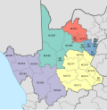
 Location of Frances Baard District Municipality within Northern Cape | |
| Coordinates: 28°30′S 24°30′E / 28.500°S 24.500°E | |
| Country | South Africa |
| Province | Northern Cape |
| Seat | Kimberley |
| Local municipalities | |
| Government | |
| • Type | Municipal council |
| • Executive Mayor | Unondumisa Buda |
| • Speaker | Keamogetse Mothibi |
| • Municipal Manager | Mamikie Bogatsu |
| Area | |
• Total | 13,518.19 km2 (5,219.40 sq mi) |
| Population (2022)[2] | |
• Total | 434 342 |
| Racial makeup (2022) | |
| • Black African | 67.1% |
| • Coloured | 23.4% |
| • Indian/Asian | 1.0% |
| • White | 8.3% |
| First languages (2011) | |
| • Tswana | 43.3% |
| • Afrikaans | 38.6% |
| • English | 6.2% |
| • Xhosa | 4.9% |
| • Other | 7% |
| Time zone | UTC+2 (SAST) |
| Municipal code | DC9 |
| Website | https://francesbaard.gov.za/ |
The Frances Baard District Municipality (Tswana: Mmasepala wa Sedika wa Frances Baard; Afrikaans: Frances Baard-distriksmunisipaliteit), previously the Diamantveld District Municipality, is one of the 5 districts of the Northern Cape province of South Africa. The seat of the municipality is Kimberley. As of 2022, the majority of its 434,342 residents speak Setswana.[4] The district code is DC9.
Previously known as the Diamantveld District Municipality, it was renamed in honour of Frances Baard in June 2001. On 9 August 2009, a statue of Frances Baard was unveiled by Northern Cape Premier Hazel Jenkins.[5]
Geography
[edit]Neighbours
[edit]Frances Baard is surrounded by:
- Dr Ruth Segomotsi Mompati (DC39) in the north
- John Taolo Gaetsewe (DC45) in the north west
- Lejweleputswa (DC18) in the east
- Pixley ka Seme (DC7) in the south
- Xhariep (DC16) in the south-west
- ZF Mgcawu (DC8) in the west
Local municipalities
[edit]The district contains the following local municipalities:
| Local municipality | Population (2022)[2] | % |
|---|---|---|
| Sol Plaatje | 270 078 | 62.18% |
| Phokwane | 80 481 | 18.53% |
| Dikgatlong | 56 967 | 13.12% |
| Magareng | 26 816 | 6.17% |
Demographics
[edit]The following statistics are from the 2022 census.[2]
Gender
[edit]| Gender | Population | % |
|---|---|---|
| Female | 226 239 | 52.09% |
| Male | 208 104 | 47.91% |
Ethnic group
[edit]| Ethnic group | Population | % |
|---|---|---|
| Black African | 291 162 | 67.1% |
| Coloured | 101 815 | 23.4% |
| White | 36 116 | 8.3% |
| Indian/Asian | 4 510 | 1.0% |
| Other | 604 | 0.1% |
Age
[edit]| Age | Population | % |
|---|---|---|
| 0 - 4 | 41 323 | 9.51% |
| 5 - 14 | 78 255 | 18.02% |
| 15 - 34 | 145 174 | 33.42% |
| 35 - 59 | 125 225 | 28.83% |
| 60+ | 44 315 | 10.2% |
Politics
[edit]Election results
[edit]Election results for Frances Baard in the South African general election, 2004.
- Population 18 and over: 206 209 [63.49% of total population]
- Total votes: 129 954 [40.01% of total population]
- Voting % estimate: 63.02% votes as a % of population 18 and over
| Party | Votes | % |
|---|---|---|
| African National Congress | 98 219 | 75.58% |
| Democratic Alliance | 14 164 | 10.90% |
| Independent Democrats | 5 086 | 3.91% |
| New National Party | 4 098 | 3.15% |
| African Christian Democratic Party | 2 211 | 1.70% |
| Azanian People's Organisation | 1 498 | 1.15% |
| Freedom Front Plus | 1 259 | 0.97% |
| United Christian Democratic Party | 1 077 | 0.83% |
| Pan African Congress | 842 | 0.65% |
| Inkhata Freedom Party | 394 | 0.30% |
| United Democratic Movement | 347 | 0.27% |
| NA | 109 | 0.08% |
| EMSA | 100 | 0.08% |
| PJC | 89 | 0.07% |
| SOPA | 89 | 0.07% |
| CDP | 80 | 0.06% |
| NLP | 76 | 0.06% |
| UF | 67 | 0.05% |
| KISS | 57 | 0.04% |
| TOP | 57 | 0.04% |
| Minority Front | 35 | 0.03% |
| Total | 129 954 | 100.00% |
References
[edit]- ^ "FBDM Council". Government Communication & Information System. Retrieved 21 December 2024.
- ^ a b c d Census 2022 (PDF)
- ^ "Statistics by place". Statistics South Africa. Retrieved 27 September 2015.
- ^ Municipal Profiles Archived 2008-10-07 at the Wayback Machine
- ^ Du Toit, A. 2009. "Baard only honoured after death" Noordkaap newspaper 19 Aug 2009:2


