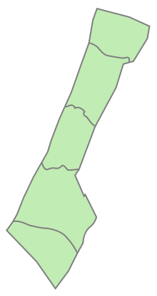
Gaza Governorate
Appearance
Gaza Governorate
محافظة غزة | |
|---|---|
 | |
| Coordinates: 31°31′N 34°27′E / 31.52°N 34.45°E | |
| Country | |
| Area | |
• Total | 70 km2 (30 sq mi) |
| Population (2017 Census)[1] | |
• Total | 652,597 |
| • Density | 9,300/km2 (24,000/sq mi) |
| ISO 3166 code | PS-GZA |
|
|
The Gaza Governorate (Arabic: محافظة غزة, romanized: Muḥāfaẓat Ġazza), also alternatively known as Gaza City Governorate, is one of the 16 Governorates of Palestine, located in the north central Gaza Strip. Gaza is claimed by the State of Palestine, but the land is under the control of Hamas,[a] while its border with Israel, airspace and maritime territory are controlled by the IDF. According to the Palestinian Central Bureau of Statistics, the district's population was 505,700 in 2006. All of its seats were won by Hamas members in the 2006 parliamentary elections. It is governed by Mohammed Qadoura.
The governorate consists of one city, three towns and a number of refugee camps.
Localities
Cities
- Gaza City (Gaza; seat)
Municipal towns
Village councils
- Juhor ad-Dik
- Madinat al-Awda
- Al-Mughraqa (Abu Middein)
Refugee camps
- Al-Shati (Shati) (Beach camp)
Notes
- ^ Designated as a terrorist group by Australia, Canada, the European Union, Israel, Japan, Paraguay, the United Kingdom, and the United States
References
- ^ "Main Indicators by Type of Locality - Population, Housing and Establishments Census 2017" (PDF). Palestinian Central Bureau of Statistics (PCBS). Retrieved 2021-01-19.
Sources
External links
 Media related to Gaza Governorate at Wikimedia Commons

