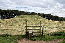
Gib Hill
 Gib Hill burial mound | |
| Location | near Middleton-by-Youlgreave and Bakewell |
|---|---|
| Region | Derbyshire, England |
| Coordinates | 53°10′01″N 01°45′52″W / 53.16694°N 1.76444°W |
| Type | tumulus |
Gib Hill is a large burial mound in the Peak District, Derbyshire, England. It is thought to be a Neolithic oval barrow with an Early Bronze Age round barrow superimposed at one end. It is located some 300 metres south-west of Arbor Low henge.

Excavations
[edit]Three exploratory excavations were conducted in the 19th century: the first by the owner, Mr Thornhill in 1812, a second by William Bateman and S. Mitchell in 1824, and a third by Thomas Bateman in 1848.[1] The 1848 excavations uncovered a cist of early Bronze Age date, containing a cremation and food vessel.[1] The complex structure of the barrow suggests that it consists of a Neolithic oval barrow with an Early Bronze Age round barrow superimposed at one end.[2] This configuration can be seen clearly by looking up at the barrow from the north.[2]
Siting
[edit]Gib Hill is part of a complex of prehistoric monuments with Arbor Low.[1] The Neolithic barrow at Gib Hill was probably the first element in the complex.[2]
