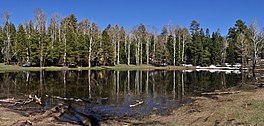
Greenland Lake
This article needs additional citations for verification. (January 2021) |
| Greenland Lake | |
|---|---|
 | |
| Location | Coconino County, Arizona, United States |
| Coordinates | 36°14′32″N 111°59′29″W / 36.2421°N 111.9913°W[1][2] |
| Basin countries | United States |
| Surface area | 5 acres (2.0 ha)l |
| Average depth | 10 ft (3.0 m) |
| Surface elevation | 8,400 ft (2,600 m) |
Greenland Lake is a small, intermittent lake of northern Arizona,[1] located at the north neck of the Walhalla Plateau (east Kaibab Plateau), in the northeast Grand Canyon. The lake is located just west (~1/8 mile), of the south-running Cape Royal Road (about 1.5 miles north of Vista Encantada), which eventually turns south-southwesterly to Cape Royal, about 15 miles distant. Greenland Lake is also about 1 mile east of Greenland Spring, at the far north of Bright Angel Canyon.
Greenland Lake is often intermittent, depending on winter snowfall; the lake is surrounded mostly by aspen, but also Ponderosa Pine, and Douglas Fir. It is a common water source for wildlife, especially deer. In historic times, cattle were grazed in the area, and a wood cabin (high-pitched roof for snow), was used for storage of salt, for cattle.


