
Gug Tappeh, Urmia
Gug Tappeh
Persian: گوگتپه | |
|---|---|
Village | |
 Assyrian St. Zayya church in Gug Tappeh | |
 Gug Tappeh | |
| Coordinates: 37°31′02″N 45°08′40″E / 37.51722°N 45.14444°E[1] | |
| Country | Iran |
| Province | West Azerbaijan |
| County | Urmia |
| District | Central |
| Rural District | Baranduzchay-ye Shomali |
| Population (2016)[2] | |
| • Total | 2,850 |
| Time zone | UTC+3:30 (IRST) |
Gug Tappeh (Persian: گوگتپه)[a] is a village in Baranduzchay-ye Shomali Rural District of the Central District of Urmia County, West Azerbaijan province, Iran.
Demographics
[edit]Population
[edit]At the time of the 2006 National Census, the village's population was 1,804 in 482 households.[4] The following census in 2011 counted 2,439 people in 706 households.[5] The 2016 census measured the population of the village as 2,850 people in 836 households. It was the most populous village in its rural district.[2]
Notable people
[edit]Gallery
[edit]-
 Assyrian Christian Family from Gug Tappeh.
 -
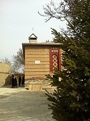 Assyrian church in Gug Tappeh.
 -
 Assyrian Christian Festival in Gug Tappeh.
 -
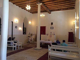 St. Zayya Church in Gug Tappeh.


See also
[edit]Notes
[edit]References
[edit]- ^ OpenStreetMap contributors (28 September 2024). "Gug Tappeh, Urmia County" (Map). OpenStreetMap (in Persian). Retrieved 28 September 2024.
- ^ a b Census of the Islamic Republic of Iran, 1395 (2016): West Azerbaijan Province. amar.org.ir (Report) (in Persian). The Statistical Center of Iran. Archived from the original (Excel) on 30 August 2022. Retrieved 19 December 2022.
- ^ Gug Tappeh can be found at GEOnet Names Server, at this link, by opening the Advanced Search box, entering "-3065292" in the "Unique Feature Id" form, and clicking on "Search Database".
- ^ Census of the Islamic Republic of Iran, 1385 (2006): West Azerbaijan Province. amar.org.ir (Report) (in Persian). The Statistical Center of Iran. Archived from the original (Excel) on 20 September 2011. Retrieved 25 September 2022.
- ^ Census of the Islamic Republic of Iran, 1390 (2011): West Azerbaijan Province. irandataportal.syr.edu (Report) (in Persian). The Statistical Center of Iran. Archived from the original (Excel) on 20 January 2023. Retrieved 19 December 2022 – via Iran Data Portal, Syracuse University.
West Azerbaijan province, Iran | ||
|---|---|---|
| Capital |  | |
| Counties and cities | ||
| Tourism | ||
| Places | ||
This Urmia County location article is a stub. You can help Wikipedia by expanding it. |