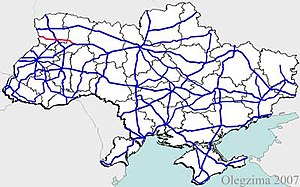
Highway H22 (Ukraine)
Appearance
| Highway H22 | ||||
|---|---|---|---|---|
| Автошлях Н22 | ||||
 | ||||
| Route information | ||||
| Length | 155.9 km (96.9 mi) | |||
| Major junctions | ||||
| West end | Polish border at Ustyluh | |||
| East end | Rivne | |||
| Location | ||||
| Country | Ukraine | |||
| Oblasts | Volyn, Rivne | |||
| Highway system | ||||
| ||||
H22 is a Ukrainian national highway (H-highway) connecting the city of Rivne with the Poland-Ukraine border.[1]
Main route
[edit]This section is missing a table that represents a list of exits or junctions. Please help by adding the missing exit or junction list. (November 2021) |
Main route and connections to/intersections with other highways in Ukraine.
| Marker | Main settlements | Notes | Highway Interchanges |
|---|---|---|---|
| Volyn Oblast | |||
| 0 km | Ustyluh | Poland-Ukraine border | |
| Volodymyr-Volynskyi | P15 | ||
| Lutsk | |||
| Rivne Oblast | |||
| 155.9 km | Rivne | Soborna vulytsia (transition) | |
See also
[edit]References
[edit]External links
[edit]- National Roads in Ukraine in Russian
- European Roads in Russian

