
Hurricane Isbell tornado outbreak
 Map plotting the track and intensity of the storm, according to the Saffir–Simpson scale | |
| Type | Tornado outbreak Tropical cyclone |
|---|---|
| Duration | October 14, 1964 |
| Tornadoes confirmed | 9 confirmed |
| Max. rating1 | F2 tornado |
| Duration of tornado outbreak2 | 7 hours and 40 minutes |
| Fatalities | 48 injuries |
| Damage | $560,250 (1964 USD)[1][nb 1] $5.5 million (2024 USD) |
| Areas affected | South Florida |
Part of the tornadoes and tornado outbreaks of 1964 1Most severe tornado damage; see Fujita scale 2Time from first tornado to last tornado | |
Hurricane Isbell spawned one of the most significant tornado outbreaks to strike the Miami metropolitan area on October 14, 1964. It produced at least nine confirmed, and possibly as many as 17, tornadoes, four of which were rated significant (F2) on the Fujita scale. Although there were no fatalities, 48 people were injured and losses totaled $560,250. The most damaging of the tornadoes was an estimated F2 that injured 22 people at a mobile home park in Briny Breezes, causing $250,000 in losses.[nb 2][nb 3][nb 4]
Background
[edit]At 21:00 UTC on October 14, 1964, Hurricane Isbell made landfall near Everglades City as a Category 2 with maximum sustained winds of 105 mph (169 km/h), having weakened somewhat from its estimated peak intensity of 115 mph (185 km/h). It quickly crossed over South Florida, spending five hours over land prior to entering the Atlantic Ocean. Much of the damage associated with the storm in South Florida was attributable to a series of tornadoes that affected the region. The tornadoes—estimates of which range from 13 to 17—were responsible for all injuries that occurred during the passage of the storm.[15][16][17][18][19][20]
Confirmed tornadoes
[edit]| FU | F0 | F1 | F2 | F3 | F4 | F5 | Total |
|---|---|---|---|---|---|---|---|
| 0 | 0 | 5 | 4 | 0 | 0 | 0 | ≥ 9 |
| F# | Location | County / Parish | State | Start coord. |
Time (UTC) | Path length | Max. width | Summary |
|---|---|---|---|---|---|---|---|---|
| F1 | Coral Gables | Miami-Dade | FL | 25°45′N 80°15′W / 25.75°N 80.25°W | 20:10–? | ≥0.1 miles (0.16 km) | 67 yards (61 m) | Damages were estimated at $2,500 (1964 USD).[22] |
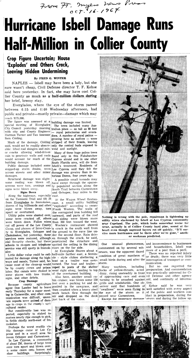
| F1 | ESE of Carnestown | Collier | FL | 25°54′N 81°30′W / 25.9°N 81.5°W | 20:15–? | ≥0.1 miles (0.16 km) | 10 yards (9.1 m) | A utility shed disintegrated and portions of the roof and siding were carried 300 feet (91 m). A chickee was flattened as well, and a cabin cruiser was moved 150 ft (46 m) into the nearby Everglades. The tornado may have occurred near Wagon Wheel, between Carnestown and Ochopee. Damages were estimated at $250 (1964 USD). NCEI lists the point of touchdown as having been east-northeast of Dismal Key.[23][24] |
| F1 | Northeastern Boca Raton | Palm Beach | FL | 26°21′N 80°05′W / 26.35°N 80.08°W | 21:00–? | ≥0.1 miles (0.16 km) | 10 yards (9.1 m) | In the 3000 and 3100 blocks of NE 5th Avenue on the east side of Boca Raton, a brief tornado tore a screen enclosure from a home. Screens, windows, awnings, and shrubbery were damaged. Three people were injured and damages were estimated at $2,500 (1964 USD). NCEI indicates that the tornado affected Pearl City.[25][26] |
| F1 | Eastern Boynton Beach | Palm Beach | FL | 26°32′N 80°04′W / 26.53°N 80.07°W | 22:00–? | ≥0.1 miles (0.16 km) | 10 yards (9.1 m) | Three people were injured and damages were estimated at $2,500 (1964 USD).[27] |
| F2 | ESE of Hobe Sound | Martin | FL | 27°03′N 80°07′W / 27.05°N 80.12°W | 22:00–? | ≥0.1 miles (0.16 km) | 10 yards (9.1 m) | A citrus stand and a service station were damaged west-northwest of Harbor Island. Damages were estimated at $2,500 (1964 USD). Tornado researcher Thomas P. Grazulis did not classify the tornado as an F2 or stronger.[28][29][30] |
| F2 | Delray Beach to Briny Breezes | Palm Beach | FL | 26°28′N 80°04′W / 26.47°N 80.07°W | 22:24–? | ≥0.1 miles (0.16 km) | 100 yards (91 m) | A tornado destroyed 12 mobile homes in the Briny Breezes Mobile Home Park and unroofed four homes southeast of Boynton Beach, injuring 22 people and causing $250,000 (1964 USD) in damage.[31][30] |
| F1 | Lake Worth Corridor to SW of Golden Lakes | Palm Beach | FL | 26°43′N 80°04′W / 26.72°N 80.07°W | 23:00–? | ≥0.1 miles (0.16 km) | 10 yards (9.1 m) | A tornado first touched down in the 3900 block of Military Trail, near the intersection of that road and Lake Worth Road. A tavern was ruined, with windows broken and the liquor stock scattered. Nearby garage doors were blown out, semi-trucks were tipped onto their sides, and trees and power poles were downed. A fire station was also damaged. The tornado continued into Forest Hills Village and Monmouth Estates, doing mostly minor damage to homes. One home had its windows broken and its furniture strewn about, and another home had its ceiling damaged. A lawn mower was thrown into a field and an automobile was thrown into a nearby yard. The tornado continued intermittently to the fairgrounds on Southern Boulevard, where signs were blown down. Three people were injured and damages were estimated at $25,000 (1964 USD).[32][33] |
| F2 | Eau Gallie | Brevard | FL | 28°08′N 80°38′W / 28.13°N 80.63°W | 01:20–? | ≥0.1 miles (0.16 km) | 10 yards (9.1 m) | A brief tornado destroyed 12 trailers, unroofed a church, and shifted a home 100 ft (30 m) in the Eau Gallie neighborhood of Northern Melbourne, injuring 17 people, and causing $250,000 (1964 USD) in damage.[34][30] |
| F2 | Davie to Dania Beach | Broward | FL | 26°04′N 80°12′W / 26.07°N 80.2°W | 03:50–? | ≥0.1 miles (0.16 km) | 10 yards (9.1 m) | A tornado hit the Fort Lauderdale–Hollywood International Airport, damaging six airplanes. A nearby clubhouse was unroofed as well and damages were estimated at $25,000 (1964 USD).[35][30] |
See also
[edit]- List of North American tornadoes and tornado outbreaks
- List of tornadoes spawned by tropical cyclones
Notes
[edit]- ^ All losses are in 1964 USD unless otherwise noted.
- ^ An outbreak is generally defined as a group of at least six tornadoes with no more than a six-hour gap between individual tornadoes; however, the threshold varies slightly according to local climatology. On the Florida peninsula, an outbreak consists of at least four tornadoes occurring relatively synchronously—no more than four hours apart.[2][3][4][5][6]
- ^ The Fujita scale was devised under the aegis of scientist T. Theodore Fujita in the early 1970s. Prior to the advent of the scale in 1971, tornadoes in the United States were officially unrated.[7][8] While the Fujita scale has been superseded by the Enhanced Fujita scale in the U.S. since February 1, 2007,[9] Canada used the old scale until April 1, 2013;[10] nations elsewhere, like the United Kingdom, apply other classifications such as the TORRO scale.[11]
- ^ Historically, the number of tornadoes globally and in the United States was and is likely underrepresented: research by Grazulis on annual tornado activity suggests that, as of 2001, only 53% of yearly U.S. tornadoes were officially recorded. Documentation of tornadoes outside the United States was historically less exhaustive, owing to the lack of monitors in many nations and, in some cases, to internal political controls on public information.[12] Most countries only recorded tornadoes that produced severe damage or loss of life.[13] Significant low biases in U.S. tornado counts likely occurred through the early 1990s, when advanced NEXRAD was first installed and the National Weather Service began comprehensively verifying tornado occurrences.[14]
- ^ All dates are based on the local time zone where the tornado touched down; however, all times are in Coordinated Universal Time and dates are split at midnight CST/CDT for consistency.
- ^ Prior to 1994, only the average widths of tornado paths were officially listed.[21]
References
[edit]- ^ Storm Data Publication 1964, Events Reported
- ^ Hagemeyer 1997, p. 400
- ^ Grazulis 2001, p. 206
- ^ Hagemeyer 1997, p. 401
- ^ Hagemeyer, Bartlett C.; Spratt, Scott M. (2002). Written at Melbourne, Florida. Thirty Years After Hurricane Agnes: the Forgotten Florida Tornado Disaster (PDF). 25th Conference on Hurricanes and Tropical Meteorology. San Diego, California: American Meteorological Society. Archived from the original (PDF) on October 16, 2008. Retrieved November 24, 2019.
- ^ Grazulis, Thomas P. (2001). The Tornado: Nature's Ultimate Windstorm. Norman: University of Oklahoma Press. p. 206. ISBN 978-0-8061-3538-0.
- ^ Grazulis 1993, p. 141.
- ^ Grazulis 2001a, p. 131.
- ^ Edwards, Roger (March 5, 2015). "Enhanced F Scale for Tornado Damage". The Online Tornado FAQ (by Roger Edwards, SPC). Storm Prediction Center. Retrieved February 25, 2016.
- ^ "Enhanced Fujita Scale (EF-Scale)". Environment and Climate Change Canada. June 6, 2013. Archived from the original on March 3, 2016. Retrieved February 25, 2016.
- ^ "The International Tornado Intensity Scale". Tornado and Storm Research Organisation. 2016. Archived from the original on March 5, 2016. Retrieved February 25, 2016.
- ^ Grazulis 2001a, pp. 251–4.
- ^ Edwards, Roger (March 5, 2015). "The Online Tornado FAQ (by Roger Edwards, SPC)". Storm Prediction Center: Frequently Asked Questions about Tornadoes. Storm Prediction Center. Retrieved February 25, 2016.
- ^ Cook & Schaefer 2008, p. 3135
- ^ USWB 1964, p. 106.
- ^ USWB 1967, p. 122.
- ^ Dunn 1965, p. 187.
- ^ U.S. Weather Bureau (October 1964). Hurricane Isbell - October 12 – 16, 1964. Miami - South Florida Weather Forecast Office (Report). Miami: National Weather Service. Retrieved August 19, 2024.
- ^ IBTrACS 2021, 1964283N15277
- ^ Hurricane Research Division (February 2008). "Chronological List of All Hurricanes which Affected the Continental United States: 1851–2007". National Hurricane Center. National Oceanic and Atmospheric Administration. Archived from the original (.TXT) on September 21, 2008. Retrieved June 18, 2014.
- ^ Brooks 2004, p. 310.
- ^ Storm Data Publication 1964, #9988785
- ^ Storm Data Publication 1964, #9988786
- ^ Winter, Fred G. (October 16, 1964). Written at Naples, Florida. "Hurricane Isbell Damage Runs Half-Million in Collier County". Fort Myers News-Press. Fort Myers, Florida. Retrieved July 2, 2020.
- ^ Storm Data Publication 1964, #9988787
- ^ "Isbell Ploughs Through Glades West of City" (PDF). Boca Raton News. Vol. 9, no. 47. Boca Raton, Florida: Boca Raton Historical Society and Museum. October 15, 1964. pp. 1A, 16A. Retrieved April 12, 2023.
- ^ Storm Data Publication 1964, #9988788
- ^ Storm Data Publication 1964, #9988789
- ^ "Storm Damage Slight, Coastal Areas Report". The Palm Beach Post. West Palm Beach, Florida. October 16, 1964.
- ^ a b c d Grazulis 1993, p. 1057.
- ^ Storm Data Publication 1964, #9988790
- ^ Storm Data Publication 1964, #9988791
- ^ "Storm Hits Hardest In Briny Breezes". The Palm Beach Post. West Palm Beach, Florida. October 15, 1964.
- ^ Storm Data Publication 1964, #9988792
- ^ Storm Data Publication 1964, #9988793
Sources
[edit]- Brooks, Harold E. (April 2004). "On the Relationship of Tornado Path Length and Width to Intensity". Weather and Forecasting. 19 (2). Boston: American Meteorological Society: 310. Bibcode:2004WtFor..19..310B. doi:10.1175/1520-0434(2004)019<0310:OTROTP>2.0.CO;2.
- Cook, A. R.; Schaefer, J. T. (August 2008). Written at Norman, Oklahoma. "The Relation of El Niño–Southern Oscillation (ENSO) to Winter Tornado Outbreaks". Monthly Weather Review. 136 (8). Boston: American Meteorological Society: 3135. Bibcode:2008MWRv..136.3121C. doi:10.1175/2007MWR2171.1.

- Dunn, Gordon (March 1965). "The Hurricane Season of 1964: Individual Tropical Cyclones: Hurricane Isbell, October 8–16". Monthly Weather Review. 93 (3). United States Weather Bureau: 185–187. Bibcode:1965MWRv...93..175D. doi:10.1175/1520-0493(1965)093<0175:THSO>2.3.CO;2. ISSN 1520-0493.
- Grazulis, Thomas P. (July 1993). Significant Tornadoes 1680–1991: A Chronology and Analysis of Events. St. Johnsbury, Vermont: The Tornado Project of Environmental Films. ISBN 1-879362-03-1.
- Grazulis, Thomas P. (2001a). The Tornado: Nature's Ultimate Windstorm. Norman: University of Oklahoma Press. ISBN 978-0-8061-3538-0.
- Grazulis, Thomas P. (2001b). F5-F6 Tornadoes. St. Johnsbury, Vermont: The Tornado Project of Environmental Films.
- Hagemeyer, Bartlett C. (September 1997). "Peninsular Florida Tornado Outbreaks". Weather and Forecasting. 12 (3). Boston: American Meteorological Society: 400. Bibcode:1997WtFor..12..399H. doi:10.1175/1520-0434(1997)012<0399:PFTO>2.0.CO;2. S2CID 120588681.
- International Best Track Archive for Climate Stewardship (IBTrACS) (May 2021). IBTrACS browser (hosted by UNC Asheville) (Report). National Centers for Environmental Information – via World Data Center for Meteorology.
- National Weather Service (October 1964). Storm Data Publication (Report). National Centers for Environmental Information – via Storm Events Database.
- U.S. Weather Bureau (October 1964). "Storm Data and Unusual Weather Phenomena". Storm Data. 6 (10). Asheville, North Carolina: National Climatic Data Center.
- U.S. Weather Bureau (September 1967). "Storm Data and Unusual Weather Phenomena". Storm Data. 9 (9). Asheville, North Carolina: National Climatic Data Center.