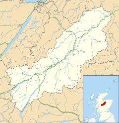
Inverdruie
Appearance
Inverdruie
| |
|---|---|
 | |
Location within the Badenoch and Strathspey area | |
| OS grid reference | NH902108 |
| Council area | |
| Country | Scotland |
| Sovereign state | United Kingdom |
| Post town | Aviemore |
| Postcode district | PH22 1 |
| Police | Scotland |
| Fire | Scottish |
| Ambulance | Scottish |
Inverdruie (Scottish Gaelic: Inbhir Dhrùidh) is a small rural hamlet, that lies 2 miles southeast of Aviemore, in the strath of the River Spey, in the west Cairngorms National Park, in Badenoch and Strathspey, Inverness-shire, Scottish Highlands and is in the Scottish council area of Highland.[1]
The single track B970 B road which connects Kingussie to Aviemore passes Inverdruie.
Gallery
[edit]References
[edit]- ^ Gittings, Bruce; Munro, David. "Inverdruie". The Gazetteer for Scotland. School of GeoSciences, University of Edinburgh and The Royal Scottish Geographical Society. Retrieved 30 July 2018.


