
Joseph Ellicott Historic District

Joseph Ellicott Historic District is a local historic district in Buffalo, New York. It is in the vicinity of Niagara Square, which was designed by Joseph Ellicott as the centerpiece of the city's street plan in 1805.
History
[edit]The district was founded on November 30, 1982, by the Buffalo Preservation Board.[1][2] It is bordered to the North by West Mohawk Street, to the East by Franklin Street, to the South by Swan Street, and to the West by Elmwood Avenue.
Sahlen Field encroached on the southern border of the district when it was built in 1988, although the Buffalo Preservation Board approved the venue's construction after the architecture was designed to match the neighboring Ellicott Square Building and Old Post Office.[3]
Notable extant buildings
[edit]Notable buildings include:
- 68 Court Street – Michael J. Dillon Memorial United States Courthouse (1936) by Edward Brodhead Green
- 107 Delaware Avenue – Statler Hotel (1923) by George B. Post and Sons
- 121 Ellicott Street – Old Post Office (1897) by James Knox Taylor
- 50 Franklin Street – St. Joseph Cathedral (1863) by Patrick Keely
- 100 Franklin Street – County and City Hall (1872) by Andrew Jackson Warner
- 237 Main Street – Marine Midland Trust Company Building (1913) by Green & Wicks
- 283 Main Street – Ellicott Square Building (1896) by Daniel Burnham
- 284 Main Street – Fidelity Trust Building (1909) by Green & Wicks
- 65 Niagara Square – Buffalo City Hall (1930) by Dietel, Wade & Jones
- 140 Pearl Street – Prudential Building (1896) by Louis H. Sullivan and Dankmar Adler[4]
Gallery
[edit]-
 St. Joseph Cathedral (1863) by Patrick Keely
 -
 County and City Hall (1872) by Andrew Jackson Warner
 -
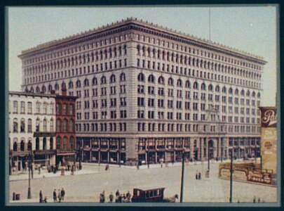 Ellicott Square Building (1896) by Daniel Burnham
 -

-
 Old Post Office (1897) by James Knox Taylor
 -
 Fidelity Trust Building (1909) by Green & Wicks
 -

-
 Statler Hotel (1923) by George B. Post and Sons
 -
 Buffalo City Hall (1930) by Dietel, Wade & Jones
 -


.jpg)

References
[edit]- ^ "Joseph Ellicott". Buffalo Architecture and History. November 30, 1982. Retrieved August 22, 2022.
- ^ "Joseph Ellicott Historic District". PRS. December 11, 2021. Retrieved August 22, 2022.
- ^ "PILOT FIELD". Buffalo News. February 19, 1995. Retrieved August 22, 2022.
- ^ Ross, Claire L. "Joseph Ellicott Historic District". Buffalo Architecture and History. Retrieved August 22, 2022.