
Jutrosin
Jutrosin | |
|---|---|
 Town hall | |
 Coat of arms | |
 Jutrosin | |
| Coordinates: 51°38′50″N 17°10′10″E / 51.64722°N 17.16944°E | |
| Country | |
| Voivodeship | Greater Poland |
| County | Rawicz |
| Gmina | Jutrosin |
| Area | |
| • Total | 1.62 km2 (0.63 sq mi) |
| Population (2014)[1] | |
| • Total | 1,947 |
| • Density | 1,200/km2 (3,100/sq mi) |
| Time zone | UTC+1 (CET) |
| • Summer (DST) | UTC+2 (CEST) |
| Postal code | 63-930 |
| Vehicle registration | PRA |
| Website | http://jutrosin.eu/ |
Jutrosin (pronounced [jutˈrɔɕin]) is a town in Rawicz County, Greater Poland Voivodeship, Poland, with 1,947 inhabitants (2014).[1] The rivers Orla and Radęca converge near the town.
History
[edit]| Year | Pop. | ±% |
|---|---|---|
| 1843 | 1,793 | — |
| 1871 | 1,977 | +10.3% |
| 1880 | 1,976 | −0.1% |
| 1890 | 1,855 | −6.1% |
| 1900 | 1,906 | +2.7% |
| 1910 | 1,804 | −5.4% |
| 1921 | 1,725 | −4.4% |
| 1931 | 1,677 | −2.8% |
| 1939 | 1,731 | +3.2% |
| 1950 | 1,390 | −19.7% |
| 1960 | 1,367 | −1.7% |
| 2010 | 1,906 | +39.4% |
| Source: [2][3][4] | ||
Jutrosin received town privileges in 1534.[5]
Jutrosin was a private town administratively located in the Pyzdry County in the Kalisz Voivodeship in the Greater Poland Province of the Kingdom of Poland.[6]
During the German occupation of Poland (World War II), a branch of the Nazi prison in Rawicz was based in Jutrosin.[7]
Gallery
[edit]-
 Centre of town
 -
 Panorama
 -
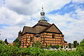 The Holy Cross Church
 -
 Church of St Elizabeth
 -
 Church of St Elizabeth, Interior
 -
 Church of St Elizabeth, stained glass by Józef Mehoffer
.JPG)


.JPG)
.JPG)
.JPG)
Notable residents
[edit]- Edmund Elend (1881–1933), merchant and department store owner
- Michael Friedländer (1833–1910), Orientalist
- Krystyna Łybacka (1946–2020), politician
- Alfred Trzebinski (1902–1946), SS-physician at the Auschwitz, Majdanek and Neuengamme concentration camps executed for war crimes
References
[edit]- ^ a b Jutrosin population based on data by Central Statistical Office, Poland.
- ^ Wiadomości Statystyczne Głównego Urzędu Statystycznego (in Polish). Vol. X. Warszawa: Główny Urząd Statystyczny. 1932. p. 202.
- ^ Dokumentacja Geograficzna (in Polish). Vol. 3/4. Warszawa: Instytut Geografii Polskiej Akademii Nauk. 1967. p. 18.
- ^ Stan i struktura ludności oraz ruch naturalny w przekroju terytorialnym w 2010 r. (PDF) (in Polish). Warszawa: Główny Urząd Statystyczny. 2011. p. 105. Archived from the original (PDF) on 13 November 2011.
- ^ Zgodziński, Bogdan (1981). Województwo leszczyńskie. Poznań: Krajowa Agencja Wydawnicza. pp. 1–76.
- ^ Atlas historyczny Polski. Wielkopolska w drugiej połowie XVI wieku. Część I. Mapy, plany (in Polish). Warszawa: Instytut Historii Polskiej Akademii Nauk. 2017. p. 1b.
- ^ Encyklopedia konspiracji Wielkopolskiej 1939–1945 (in Polish). Poznań: Instytut Zachodni. 1998. p. 478. ISBN 83-85003-97-5.
External links
[edit] Media related to Jutrosin at Wikimedia Commons
- Historia Żydów w Jutrosinie na portalu Wirtualny Sztetl
| Town and seat | | |
|---|---|---|
| Villages | ||
| International | |
|---|---|
| National | |
This Rawicz County location article is a stub. You can help Wikipedia by expanding it. |